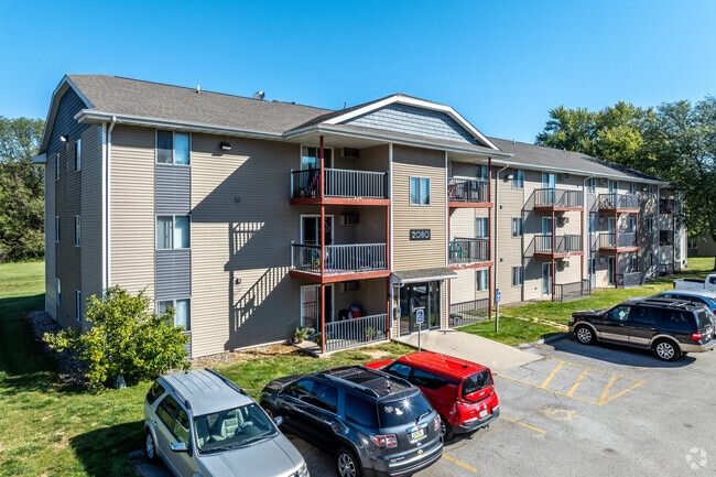
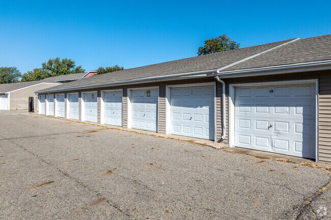
Property Record
2080 King Ave, Des Moines, IA 50320
NEARBY LISTINGS FOR SALE OR LEASE
Property Detail
2080 King Ave
Des Moines-West Des Moines, IA
Park Forest Plat 4
010-03972654000
LOT 3 PARK FOREST PLAT 4
Apartment
Polk
X
Iowa
19153C0365F
3
2024
13.35 AC
2025
Pioneer Park
003901
Des Moines
178,415 SF
DEMOGRAPHICS near 2080 King Ave
1 Mile
3 Mile
5 Mile
2024 Total Population
8,930
63,909
158,567
2029 Population
9,206
66,567
165,351
Pop Growth 2024-2029
+ 3.09%
+ 4.16%
+ 4.28%
Average Age
35
36
37
2024 Total Households
3,197
26,381
64,947
HH Growth 2024-2029
+ 3.28%
+ 4.57%
+ 4.59%
Median Household Inc
$69,060
$57,130
$56,238
Avg Household Size
2.70
2.30
2.30
2024 Avg HH Vehicles
2.00
2.00
2.00
Median Home Value
$179,705
$151,716
$156,469
Median Year Built
1982
1973
1968
Nearby Places
Map Layers
Map Styles
 Street
 Aerial
- Restaurants
- Banks
- Shops
- Fitness
- Groceries
PUBLIC TRANSPORTATION
AIRPORT
Des Moines International
DRIVE
WALK
Distance
Des Moines International
14 min
6.1 mi
Freight Ports
Port Milwaukee
DRIVE
WALK
Distance
Port Milwaukee
421 min
375.8 mi
Nearby Properties
Address
Land Use
TOTAL SIZE
Lot Size
Zoning
Address
Land Use
TOTAL SIZE
Lot Size
Zoning
177,094 SF
24.60 AC
Address
Land Use
TOTAL SIZE
Lot Size
Zoning
300,115 SF
2.48 AC
Address
Land Use
TOTAL SIZE
Lot Size
Zoning
208,955 SF
1.84 AC
Address
Land Use
TOTAL SIZE
Lot Size
Zoning
335,556 SF
0.86 AC
C-3
Address
Land Use
TOTAL SIZE
Lot Size
Zoning
402,849 SF
0.83 AC
C-3
Address
Land Use
TOTAL SIZE
Lot Size
Zoning
432,630 SF
0.82 AC
C-3
Address
Land Use
TOTAL SIZE
Lot Size
Zoning
475,929 SF
49.86 AC
M2
Address
Land Use
TOTAL SIZE
Lot Size
Zoning
342,000 SF
22.18 AC
Address
Land Use
TOTAL SIZE
Lot Size
Zoning
178,611 SF
3.02 AC
Address
Land Use
TOTAL SIZE
Lot Size
Zoning
257,407 SF
1.43 AC
Address
Land Use
TOTAL SIZE
Lot Size
Zoning
127,000 SF
1.92 AC
Address
Land Use
TOTAL SIZE
Lot Size
Zoning
427,768 SF
0.87 AC
C-3
Address
Land Use
TOTAL SIZE
Lot Size
Zoning
249,188 SF
0.39 AC
Address
Land Use
TOTAL SIZE
Lot Size
Zoning
555,952 SF
2 AC
C-3
Address
Land Use
TOTAL SIZE
Lot Size
Zoning
117,000 SF
4.02 AC
PUD
Address
Land Use
TOTAL SIZE
Lot Size
Zoning
184,659 SF
4.10 AC
Address
Land Use
TOTAL SIZE
Lot Size
Zoning
123,535 SF
0.63 AC
Address
Land Use
TOTAL SIZE
Lot Size
Zoning
162,217 SF
6.32 AC
Address
Land Use
TOTAL SIZE
Lot Size
Zoning
211,621 SF
0.87 AC
C3
Address
Land Use
TOTAL SIZE
Lot Size
Zoning
141,100 SF
0.47 AC
Address
Land Use
TOTAL SIZE
Lot Size
Zoning
585,881 SF
0.85 AC
C-3
Address
Land Use
TOTAL SIZE
Lot Size
Zoning
218,593 SF
19.31 AC
M-2
Address
Land Use
TOTAL SIZE
Lot Size
Zoning
349,689 SF
0.70 AC
C-3
Address
Land Use
TOTAL SIZE
Lot Size
Zoning
274,385 SF
3.83 AC
D-R
Address
Land Use
TOTAL SIZE
Lot Size
Zoning
95,384 SF
3.23 AC
Address
Land Use
TOTAL SIZE
Lot Size
Zoning
144,255 SF
0.27 AC
C-3
Address
Land Use
TOTAL SIZE
Lot Size
Zoning
118,080 SF
15.76 AC
Address
Land Use
TOTAL SIZE
Lot Size
Zoning
175,854 SF
22.81 AC
Address
Land Use
TOTAL SIZE
Lot Size
Zoning
96,032 SF
1.74 AC
The World's #1 Commercial Real Estate Marketplace
Connect with us
© 2026 CoStar Group
The information above has been obtained from sources believed reliable. While we do not doubt its accuracy we have not verified it and make no guarantee, warranty or representation about it. It is your responsibility to independently confirm its accuracy and completeness. Any projections, opinions, assumptions, or estimates used are for example only and do not represent the current or future performance of the property. The value of this transaction to you depends on tax and other factors which should be evaluated by your tax, financial, and legal advisors. You and your advisors should conduct a careful, independent investigation of the property to determine to your satisfaction the suitability of the property for your needs.