Property Record
2080 Moore Rd, Redding, CA 96001
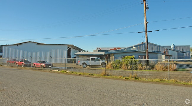

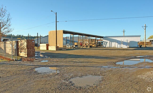
Property Detail
2080 Moore Rd
048-240-062-000
Shasta
Industrialgeneral
California
B and X Area of moderate flood hazard, usually the area between the limits of the 100-year and 500-year floods.
6.23 AC
2024
Redding/Chico
2025
Other Market Areas
010400
Redding, CA
NEARBY LISTINGS FOR SALE OR LEASE
DEMOGRAPHICS near 2080 Moore Rd
1 mile
3 mile
5 mile
2025 Total Population
4,283
39,805
89,565
2030 Population
4,333
39,975
89,922
Pop Growth 2025-2030
+ 1.17%
+ 0.43%
+ 0.40%
Average Age
41
41
41
2025 Total Households
1,665
15,566
35,677
HH Growth 2025-2030
+ 1.20%
+ 0.43%
+ 0.40%
Median Household Inc
$75,055
$75,696
$77,317
Avg Household Size
2.50
2.40
2.40
2025 Avg HH Vehicles
2.00
2.00
2.00
Median Home Value
$354,027
$358,842
$378,140
Median Year Built
1972
1977
1981
Nearby Places
Map Layers
Map Styles
 Street
 Aerial
Transit
 Traffic
 Biking
Places
Listings with unknown addresses are not visible on the map
- Restaurants
- Banks
- Shops
- Fitness
- Groceries
PUBLIC TRANSPORTATION
COMMUTER RAIL
Redding Amtrak (Coast Starlight - Amtrak)
Drive
Walk
Distance
Redding Amtrak (Coast Starlight - Amtrak)
8 min
3.7 mi
AIRPORT
Redding Regional
Drive
Walk
Distance
Redding Regional
13 min
7.3 mi
Freight Ports
Port of Richmond
Drive
Walk
Distance
Port of Richmond
230 min
203.2 mi
SALE & LEASE HISTORY
LISTING DATE
SALE/LEASE

Sep 24, 2016
For Sale
Nearby Properties
Address
Land Use
TOTAL SIZE
Lot Size
Zoning
Address
Land Use
TOTAL SIZE
Lot Size
Zoning
15.20 AC
Address
Land Use
TOTAL SIZE
Lot Size
Zoning
151,773 SF
17.64 AC
Address
Land Use
TOTAL SIZE
Lot Size
Zoning
89,098 SF
7.24 AC
Address
Land Use
TOTAL SIZE
Lot Size
Zoning
47,062 SF
4.80 AC
Address
Land Use
TOTAL SIZE
Lot Size
Zoning
81,800 SF
14.81 AC
Address
Land Use
TOTAL SIZE
Lot Size
Zoning
50,251 SF
4.06 AC
Address
Land Use
TOTAL SIZE
Lot Size
Zoning
61,754 SF
1.73 AC
Address
Land Use
TOTAL SIZE
Lot Size
Zoning
92,699 SF
5.91 AC
Address
Land Use
TOTAL SIZE
Lot Size
Zoning
344.24 AC
U
Address
Land Use
TOTAL SIZE
Lot Size
Zoning
11.90 AC
Address
Land Use
TOTAL SIZE
Lot Size
Zoning
83,276 SF
3.02 AC
Address
Land Use
TOTAL SIZE
Lot Size
Zoning
16,320 SF
3.76 AC
Address
Land Use
TOTAL SIZE
Lot Size
Zoning
55,351 SF
5.65 AC
Address
Land Use
TOTAL SIZE
Lot Size
Zoning
11.80 AC
Address
Land Use
TOTAL SIZE
Lot Size
Zoning
10.28 AC
Address
Land Use
TOTAL SIZE
Lot Size
Zoning
4.20 AC
Address
Land Use
TOTAL SIZE
Lot Size
Zoning
50,609 SF
4.62 AC
Address
Land Use
TOTAL SIZE
Lot Size
Zoning
90,832 SF
12.44 AC
C-2
Address
Land Use
TOTAL SIZE
Lot Size
Zoning
65,920 SF
11.34 AC
Address
Land Use
TOTAL SIZE
Lot Size
Zoning
51,435 SF
4.54 AC
Address
Land Use
TOTAL SIZE
Lot Size
Zoning
3,178 SF
3.58 AC
Address
Land Use
TOTAL SIZE
Lot Size
Zoning
30,620 SF
1.85 AC
Address
Land Use
TOTAL SIZE
Lot Size
Zoning
46,114 SF
2.93 AC
Address
Land Use
TOTAL SIZE
Lot Size
Zoning
44,988 SF
3.50 AC
Address
Land Use
TOTAL SIZE
Lot Size
Zoning
2,400 SF
13 AC
Address
Land Use
TOTAL SIZE
Lot Size
Zoning
75,145 SF
5.95 AC
Address
Land Use
TOTAL SIZE
Lot Size
Zoning
21,920 SF
1.17 AC
Address
Land Use
TOTAL SIZE
Lot Size
Zoning
2.50 AC
Address
Land Use
TOTAL SIZE
Lot Size
Zoning
7.26 AC
Address
Land Use
TOTAL SIZE
Lot Size
Zoning
7.29 AC
The World's #1 Commercial Real Estate Marketplace
Connect with us
© 2026 CoStar Group
The information above has been obtained from sources believed reliable. While we do not doubt its accuracy we have not verified it and make no guarantee, warranty or representation about it. It is your responsibility to independently confirm its accuracy and completeness. Any projections, opinions, assumptions, or estimates used are for example only and do not represent the current or future performance of the property. The value of this transaction to you depends on tax and other factors which should be evaluated by your tax, financial, and legal advisors. You and your advisors should conduct a careful, independent investigation of the property to determine to your satisfaction the suitability of the property for your needs.