Property Record
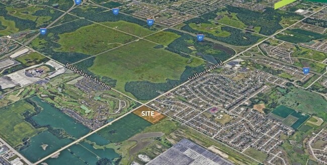
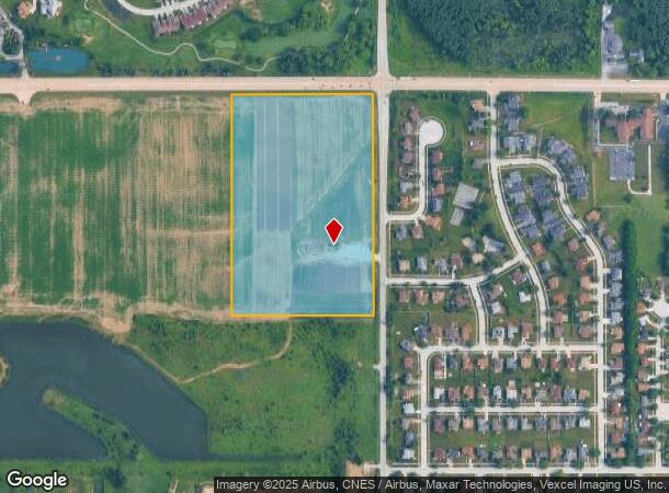
20800 S Ridgeland Ave, Matteson, IL 60443
This Property Is For Sale
NEARBY LISTINGS FOR SALE OR LEASE
Property Detail
20800 S Ridgeland Ave
31-18-202-003-0000
Cook
Farms
Illinois
X
20.56 AC
17031C0719J
Far South
2023
Chicago
2024
Chicago-Naperville-Elgin, IL-IN-WI
830004
DEMOGRAPHICS near 20800 S Ridgeland Ave
1 Mile
3 Mile
5 Mile
2024 Total Population
4,210
44,085
154,861
2029 Population
4,083
43,183
151,688
Pop Growth 2024-2029
(3.02%)
(2.05%)
(2.05%)
Average Age
43
42
42
2024 Total Households
1,538
16,380
56,959
HH Growth 2024-2029
(3.38%)
(2.33%)
(2.36%)
Median Household Inc
$87,644
$92,955
$90,501
Avg Household Size
2.70
2.60
2.60
2024 Avg HH Vehicles
2.00
2.00
2.00
Median Home Value
$219,370
$245,506
$250,796
Median Year Built
1985
1990
1983
Nearby Places
Map Layers
Map Styles
 Street
 Aerial
- Restaurants
- Banks
- Shops
- Fitness
- Groceries
PUBLIC TRANSPORTATION
COMMUTER RAIL
Tinley Park - 80Th Avenue Station (Rock Island District Line - Northeast Illinois Regional Commuter Railroad (Metra))
DRIVE
WALK
Distance
Tinley Park - 80Th Avenue Station (Rock Island District Line - Northeast Illinois Regional Commuter Railroad (Metra))
10 min
4.6 mi
Tinley Park Station (Rock Island District Line - Northeast Illinois Regional Commuter Railroad (Metra))
DRIVE
WALK
Distance
Tinley Park Station (Rock Island District Line - Northeast Illinois Regional Commuter Railroad (Metra))
9 min
4.9 mi
AIRPORT
Chicago Midway International
DRIVE
WALK
Distance
Chicago Midway International
35 min
21.2 mi
Freight Ports
Port Milwaukee
DRIVE
WALK
Distance
Port Milwaukee
141 min
112.7 mi
Nearby Properties
Address
Land Use
TOTAL SIZE
Lot Size
Zoning
Address
Land Use
TOTAL SIZE
Lot Size
Zoning
3,480,853 SF
Address
Land Use
TOTAL SIZE
Lot Size
Zoning
757,504 SF
46.30 AC
Address
Land Use
TOTAL SIZE
Lot Size
Zoning
37.62 AC
Address
Land Use
TOTAL SIZE
Lot Size
Zoning
30.10 AC
Address
Land Use
TOTAL SIZE
Lot Size
Zoning
Address
Land Use
TOTAL SIZE
Lot Size
Zoning
Address
Land Use
TOTAL SIZE
Lot Size
Zoning
1,033,450 SF
Address
Land Use
TOTAL SIZE
Lot Size
Zoning
168,708 SF
14.74 AC
Address
Land Use
TOTAL SIZE
Lot Size
Zoning
911,379 SF
51.23 AC
Address
Land Use
TOTAL SIZE
Lot Size
Zoning
173,415 SF
14.97 AC
Address
Land Use
TOTAL SIZE
Lot Size
Zoning
11.84 AC
Address
Land Use
TOTAL SIZE
Lot Size
Zoning
238,068 SF
13.96 AC
Address
Land Use
TOTAL SIZE
Lot Size
Zoning
134,148 SF
5 AC
Address
Land Use
TOTAL SIZE
Lot Size
Zoning
150,289 SF
16.40 AC
Address
Land Use
TOTAL SIZE
Lot Size
Zoning
224,611 SF
0.90 AC
Address
Land Use
TOTAL SIZE
Lot Size
Zoning
322,629 SF
53.73 AC
Address
Land Use
TOTAL SIZE
Lot Size
Zoning
4,168 SF
145.94 AC
Address
Land Use
TOTAL SIZE
Lot Size
Zoning
280,313 SF
12.75 AC
Address
Land Use
TOTAL SIZE
Lot Size
Zoning
2.04 AC
Address
Land Use
TOTAL SIZE
Lot Size
Zoning
250,656 SF
Address
Land Use
TOTAL SIZE
Lot Size
Zoning
106,359 SF
8.25 AC
Address
Land Use
TOTAL SIZE
Lot Size
Zoning
40,000 SF
4.98 AC
Address
Land Use
TOTAL SIZE
Lot Size
Zoning
130,753 SF
8.12 AC
Address
Land Use
TOTAL SIZE
Lot Size
Zoning
3,011 SF
125.12 AC
Address
Land Use
TOTAL SIZE
Lot Size
Zoning
133,342 SF
11.63 AC
Address
Land Use
TOTAL SIZE
Lot Size
Zoning
92,166 SF
23.83 AC
Address
Land Use
TOTAL SIZE
Lot Size
Zoning
70,848 SF
10.18 AC
Address
Land Use
TOTAL SIZE
Lot Size
Zoning
96,255 SF
12.01 AC
Address
Land Use
TOTAL SIZE
Lot Size
Zoning
Address
Land Use
TOTAL SIZE
Lot Size
Zoning
55,435 SF
6.43 AC
The World's #1 Commercial Real Estate Marketplace
Connect with us
© 2025 CoStar Group
The information above has been obtained from sources believed reliable. While we do not doubt its accuracy we have not verified it and make no guarantee, warranty or representation about it. It is your responsibility to independently confirm its accuracy and completeness. Any projections, opinions, assumptions, or estimates used are for example only and do not represent the current or future performance of the property. The value of this transaction to you depends on tax and other factors which should be evaluated by your tax, financial, and legal advisors. You and your advisors should conduct a careful, independent investigation of the property to determine to your satisfaction the suitability of the property for your needs.