Property Record
20807 Clay Center Dr, Katy, TX 77449
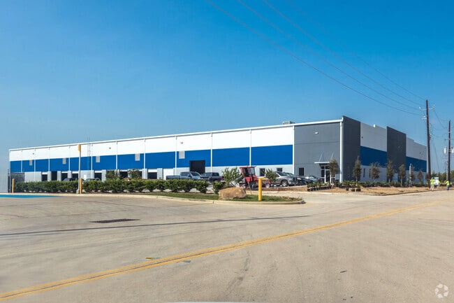
Property Detail
20807 Clay Center Dr
Houston-Pasadena-The Woodlands, TX
RES B4A BLK 2 CLAY ROAD COMMERCE PARK
1406410020005
HARRIS
Lightindustrial
Texas
2024
3 AC
2025
Northwest Outliers
542202
Houston
64,539 SF
NEARBY LISTINGS FOR SALE OR LEASE
DEMOGRAPHICS near 20807 Clay Center Dr
1 mile
3 mile
5 mile
2025 Total Population
16,290
142,867
328,190
2030 Population
17,452
153,015
352,207
Pop Growth 2025-2030
+ 7.13%
+ 7.10%
+ 7.32%
Average Age
34
35
36
2025 Total Households
4,548
42,774
103,409
HH Growth 2025-2030
+ 7.28%
+ 7.25%
+ 7.50%
Median Household Inc
$96,057
$90,465
$89,823
Avg Household Size
3.50
3.30
3.10
2025 Avg HH Vehicles
2.00
2.00
2.00
Median Home Value
$278,683
$266,095
$281,355
Median Year Built
2007
2005
2004
Nearby Places
Map Layers
Map Styles
 Street
 Aerial
Layers
 Traffic
 Biking
Places
Listings with unknown addresses are not visible on the map
- Restaurants
- Banks
- Shops
- Fitness
- Groceries
PUBLIC TRANSPORTATION
AIRPORT
George Bush Intcntl/Houston
Drive
Walk
Distance
George Bush Intcntl/Houston
47 min
34.5 mi
William P Hobby
Drive
Walk
Distance
William P Hobby
60 min
39.5 mi
Freight Ports
Port of Houston
Drive
Walk
Distance
Port of Houston
53 min
36.2 mi
SALE & LEASE HISTORY
LISTING DATE
SALE/LEASE

Jul 07, 2022
For Sale
Nearby Properties
Address
Land Use
TOTAL SIZE
Lot Size
Zoning
Address
Land Use
TOTAL SIZE
Lot Size
Zoning
807,360 SF
54.15 AC
Address
Land Use
TOTAL SIZE
Lot Size
Zoning
838,700 SF
36.68 AC
Address
Land Use
TOTAL SIZE
Lot Size
Zoning
891,129 SF
44.39 AC
Address
Land Use
TOTAL SIZE
Lot Size
Zoning
339,835 SF
12.09 AC
Address
Land Use
TOTAL SIZE
Lot Size
Zoning
324,201 SF
12.39 AC
Address
Land Use
TOTAL SIZE
Lot Size
Zoning
290,973 SF
15 AC
Address
Land Use
TOTAL SIZE
Lot Size
Zoning
347,834 SF
15.25 AC
Address
Land Use
TOTAL SIZE
Lot Size
Zoning
272,033 SF
12.74 AC
Address
Land Use
TOTAL SIZE
Lot Size
Zoning
335,899 SF
12.62 AC
Address
Land Use
TOTAL SIZE
Lot Size
Zoning
395,495 SF
13.83 AC
Address
Land Use
TOTAL SIZE
Lot Size
Zoning
331,263 SF
11.36 AC
Address
Land Use
TOTAL SIZE
Lot Size
Zoning
266,532 SF
6.45 AC
Address
Land Use
TOTAL SIZE
Lot Size
Zoning
292,645 SF
12.71 AC
Address
Land Use
TOTAL SIZE
Lot Size
Zoning
439,808 SF
23.75 AC
Address
Land Use
TOTAL SIZE
Lot Size
Zoning
290,607 SF
14.50 AC
Address
Land Use
TOTAL SIZE
Lot Size
Zoning
385,744 SF
25.88 AC
Address
Land Use
TOTAL SIZE
Lot Size
Zoning
236,406 SF
11.40 AC
Address
Land Use
TOTAL SIZE
Lot Size
Zoning
375,152 SF
19.57 AC
Address
Land Use
TOTAL SIZE
Lot Size
Zoning
262,174 SF
11.64 AC
Address
Land Use
TOTAL SIZE
Lot Size
Zoning
334,971 SF
18.43 AC
Address
Land Use
TOTAL SIZE
Lot Size
Zoning
262,943 SF
11.51 AC
Address
Land Use
TOTAL SIZE
Lot Size
Zoning
131,544 SF
19.04 AC
Address
Land Use
TOTAL SIZE
Lot Size
Zoning
235,154 SF
13 AC
Address
Land Use
TOTAL SIZE
Lot Size
Zoning
693,781 SF
6.86 AC
Address
Land Use
TOTAL SIZE
Lot Size
Zoning
420,370 SF
17.05 AC
Address
Land Use
TOTAL SIZE
Lot Size
Zoning
151,385 SF
8.58 AC
Address
Land Use
TOTAL SIZE
Lot Size
Zoning
270,000 SF
14.25 AC
Address
Land Use
TOTAL SIZE
Lot Size
Zoning
211,757 SF
9.02 AC
Address
Land Use
TOTAL SIZE
Lot Size
Zoning
122,133 SF
13.46 AC
Address
Land Use
TOTAL SIZE
Lot Size
Zoning
54,306 SF
3.78 AC
The World's #1 Commercial Real Estate Marketplace
Connect with us
© 2026 CoStar Group
The information above has been obtained from sources believed reliable. While we do not doubt its accuracy we have not verified it and make no guarantee, warranty or representation about it. It is your responsibility to independently confirm its accuracy and completeness. Any projections, opinions, assumptions, or estimates used are for example only and do not represent the current or future performance of the property. The value of this transaction to you depends on tax and other factors which should be evaluated by your tax, financial, and legal advisors. You and your advisors should conduct a careful, independent investigation of the property to determine to your satisfaction the suitability of the property for your needs.