Property Record
20807 Stockdale Hwy, Bakersfield, CA 93314


NEARBY LISTINGS FOR SALE OR LEASE
-
-
View all Bakersfield listings for sale on LoopNet.com
Property Detail
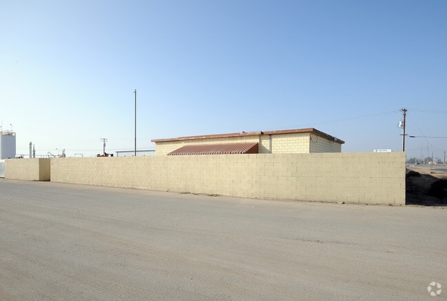
20807 Stockdale Hwy
524-020-22-00-9
SECTION 6 , TOWNSHIP 30 , RANGE 26 , QUARTER
Foundry
Kern
X
California
06029C2275F
26.74 AC
2024
NW Outlying Kern County
2025
Bakersfield
003213
Bakersfield-Delano, CA
4,000 SF
DEMOGRAPHICS near 20807 Stockdale Hwy
1 Mile
3 Mile
5 Mile
2024 Total Population
24
3,098
24,694
2029 Population
24
3,108
25,061
Pop Growth 2024-2029
0.00%
+ 0.32%
+ 1.49%
Average Age
39
38
37
2024 Total Households
8
941
7,814
HH Growth 2024-2029
0.00%
+ 0.21%
+ 1.42%
Median Household Inc
$162,500
$131,250
$136,655
Avg Household Size
3.00
3.30
3.10
2024 Avg HH Vehicles
3.00
3.00
2.00
Median Home Value
$874,999
$685,897
$457,697
Median Year Built
1997
1999
2003
Nearby Places
Map Layers
Map Styles
 Street
 Aerial
- Restaurants
- Banks
- Shops
- Fitness
- Groceries
PUBLIC TRANSPORTATION
AIRPORT
Meadows Field
DRIVE
WALK
Distance
Meadows Field
27 min
15.6 mi
Freight Ports
The Port of Hueneme
DRIVE
WALK
Distance
The Port of Hueneme
159 min
127.5 mi
Nearby Properties
Address
Land Use
TOTAL SIZE
Lot Size
Zoning
Address
Land Use
TOTAL SIZE
Lot Size
Zoning
319,531 SF
17.66 AC
R3
Address
Land Use
TOTAL SIZE
Lot Size
Zoning
307.76 AC
A
Address
Land Use
TOTAL SIZE
Lot Size
Zoning
Address
Land Use
TOTAL SIZE
Lot Size
Zoning
Address
Land Use
TOTAL SIZE
Lot Size
Zoning
6,250 SF
19.12 AC
NR
Address
Land Use
TOTAL SIZE
Lot Size
Zoning
6,000 SF
5.61 AC
M2/PD
Address
Land Use
TOTAL SIZE
Lot Size
Zoning
4,800 SF
25.70 AC
Address
Land Use
TOTAL SIZE
Lot Size
Zoning
4,100 SF
2.40 AC
A-1
Address
Land Use
TOTAL SIZE
Lot Size
Zoning
8,155 SF
10.43 AC
C2
Address
Land Use
TOTAL SIZE
Lot Size
Zoning
6,000 SF
4.60 AC
M-1
Address
Land Use
TOTAL SIZE
Lot Size
Zoning
2.42 AC
A1
Address
Land Use
TOTAL SIZE
Lot Size
Zoning
19.34 AC
A
Address
Land Use
TOTAL SIZE
Lot Size
Zoning
79.09 AC
A
Address
Land Use
TOTAL SIZE
Lot Size
Zoning
64.89 AC
A
Address
Land Use
TOTAL SIZE
Lot Size
Zoning
156.36 AC
A
Address
Land Use
TOTAL SIZE
Lot Size
Zoning
306.33 AC
A
Address
Land Use
TOTAL SIZE
Lot Size
Zoning
Address
Land Use
TOTAL SIZE
Lot Size
Zoning
5,000 SF
7.34 AC
M2
Address
Land Use
TOTAL SIZE
Lot Size
Zoning
3,456 SF
10.42 AC
A1
Address
Land Use
TOTAL SIZE
Lot Size
Zoning
2,400 SF
8.43 AC
A
Address
Land Use
TOTAL SIZE
Lot Size
Zoning
2,637 SF
4.73 AC
M1PD
Address
Land Use
TOTAL SIZE
Lot Size
Zoning
78.77 AC
A
Address
Land Use
TOTAL SIZE
Lot Size
Zoning
9,875 SF
4.18 AC
A-1
Address
Land Use
TOTAL SIZE
Lot Size
Zoning
Address
Land Use
TOTAL SIZE
Lot Size
Zoning
8,000 SF
4.64 AC
NR(5)PD
Address
Land Use
TOTAL SIZE
Lot Size
Zoning
164.47 AC
A
Address
Land Use
TOTAL SIZE
Lot Size
Zoning
8,687 SF
20.78 AC
A
The World's #1 Commercial Real Estate Marketplace
Connect with us
© 2026 CoStar Group
The information above has been obtained from sources believed reliable. While we do not doubt its accuracy we have not verified it and make no guarantee, warranty or representation about it. It is your responsibility to independently confirm its accuracy and completeness. Any projections, opinions, assumptions, or estimates used are for example only and do not represent the current or future performance of the property. The value of this transaction to you depends on tax and other factors which should be evaluated by your tax, financial, and legal advisors. You and your advisors should conduct a careful, independent investigation of the property to determine to your satisfaction the suitability of the property for your needs.