Property Record
2081 County Route 1, Oswego, NY 13126
NEARBY LISTINGS FOR SALE OR LEASE
Property Detail
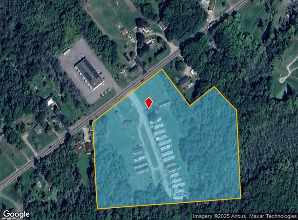
2081 County Route 1
355600-111-000-0004-023-021-0000
Serihas Patent
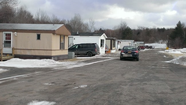
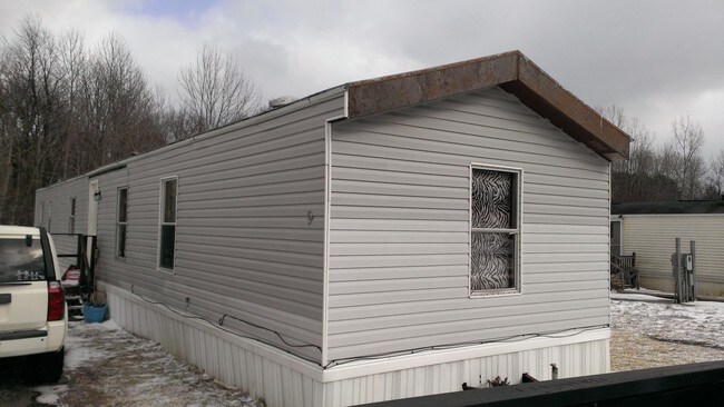
Mobilehomepark
Oswego
X
New York
36075C0277H
23.210
2025
12.47 AC
2024
Oswego County
021504
Syracuse
980 SF
Syracuse, NY
DEMOGRAPHICS near 2081 County Route 1
1 Mile
3 Mile
5 Mile
2024 Total Population
661
13,526
27,418
2029 Population
675
13,653
27,607
Pop Growth 2024-2029
+ 2.12%
+ 0.94%
+ 0.69%
Average Age
43
42
40
2024 Total Households
288
5,840
10,763
HH Growth 2024-2029
+ 2.08%
+ 0.98%
+ 0.71%
Median Household Inc
$54,062
$50,210
$51,475
Avg Household Size
2.30
2.20
2.20
2024 Avg HH Vehicles
1.00
1.00
2.00
Median Home Value
$111,290
$125,199
$127,871
Median Year Built
1985
1961
1958
Nearby Places
- Restaurants
- Banks
- Shops
- Fitness
- Groceries
SALE & LEASE HISTORY
LISTING DATE
SALE/LEASE

Jun 08, 2018
For Sale
Jul 27, 2017
For Sale
Nearby Properties
Address
Land Use
TOTAL SIZE
Lot Size
Zoning
Address
Land Use
TOTAL SIZE
Lot Size
Zoning
54.93 AC
Address
Land Use
TOTAL SIZE
Lot Size
Zoning
51.50 AC
NONE
Address
Land Use
TOTAL SIZE
Lot Size
Zoning
50.74 AC
Address
Land Use
TOTAL SIZE
Lot Size
Zoning
Address
Land Use
TOTAL SIZE
Lot Size
Zoning
600 SF
27.36 AC
IN
Address
Land Use
TOTAL SIZE
Lot Size
Zoning
13,576 SF
4.54 AC
IN
Address
Land Use
TOTAL SIZE
Lot Size
Zoning
5,604 SF
0.33 AC
SR
Address
Land Use
TOTAL SIZE
Lot Size
Zoning
Address
Land Use
TOTAL SIZE
Lot Size
Zoning
494.36 AC
Address
Land Use
TOTAL SIZE
Lot Size
Zoning
36,360 SF
9.04 AC
PD
Address
Land Use
TOTAL SIZE
Lot Size
Zoning
4.50 AC
Address
Land Use
TOTAL SIZE
Lot Size
Zoning
153,253 SF
17.79 AC
CB
Address
Land Use
TOTAL SIZE
Lot Size
Zoning
42,320 SF
4.88 AC
TB
Address
Land Use
TOTAL SIZE
Lot Size
Zoning
91,452 SF
1.54 AC
TB
Address
Land Use
TOTAL SIZE
Lot Size
Zoning
5,265 SF
77.55 AC
01 - NOT Z
Address
Land Use
TOTAL SIZE
Lot Size
Zoning
37,942 SF
0.46 AC
TB
Address
Land Use
TOTAL SIZE
Lot Size
Zoning
111,332 SF
15.38 AC
CB
Address
Land Use
TOTAL SIZE
Lot Size
Zoning
7.89 AC
Address
Land Use
TOTAL SIZE
Lot Size
Zoning
106,410 SF
19.77 AC
CB
Address
Land Use
TOTAL SIZE
Lot Size
Zoning
140,380 SF
19.17 AC
CB
Address
Land Use
TOTAL SIZE
Lot Size
Zoning
28,286 SF
14.93 AC
CB
Address
Land Use
TOTAL SIZE
Lot Size
Zoning
118,289 SF
9.02 AC
PD
Address
Land Use
TOTAL SIZE
Lot Size
Zoning
95,923 SF
9.43 AC
CB
Address
Land Use
TOTAL SIZE
Lot Size
Zoning
51,000 SF
3.80 AC
PD
Address
Land Use
TOTAL SIZE
Lot Size
Zoning
74,770 SF
2.25 AC
TB
Address
Land Use
TOTAL SIZE
Lot Size
Zoning
48,598 SF
4.65 AC
TN1
Address
Land Use
TOTAL SIZE
Lot Size
Zoning
4,914 SF
23.95 AC
TN2
Address
Land Use
TOTAL SIZE
Lot Size
Zoning
2,380 SF
42.70 AC
TN2
Address
Land Use
TOTAL SIZE
Lot Size
Zoning
57,636 SF
3.85 AC
CB
The World's #1 Commercial Real Estate Marketplace
Connect with us
© 2025 CoStar Group
The information above has been obtained from sources believed reliable. While we do not doubt its accuracy we have not verified it and make no guarantee, warranty or representation about it. It is your responsibility to independently confirm its accuracy and completeness. Any projections, opinions, assumptions, or estimates used are for example only and do not represent the current or future performance of the property. The value of this transaction to you depends on tax and other factors which should be evaluated by your tax, financial, and legal advisors. You and your advisors should conduct a careful, independent investigation of the property to determine to your satisfaction the suitability of the property for your needs.