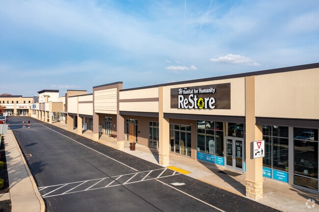
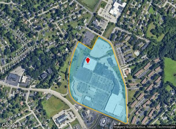
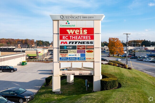
Property Record
2081 Springwood Rd, York, PA 17403
NEARBY LISTINGS FOR SALE OR LEASE
Property Detail
2081 Springwood Rd
Communitycenter
York
X
Pennsylvania
42133C0329F
35.12 AC
2025
York County
2025
Philadelphia
022702
York-Hanover, PA
286,411 SF
54-000-II-0029.C0-00000
DEMOGRAPHICS near 2081 Springwood Rd
1 Mile
3 Mile
5 Mile
2024 Total Population
7,321
81,500
157,071
2029 Population
7,506
83,767
161,155
Pop Growth 2024-2029
+ 2.53%
+ 2.78%
+ 2.60%
Average Age
43
39
40
2024 Total Households
3,127
31,318
60,847
HH Growth 2024-2029
+ 2.53%
+ 2.85%
+ 2.67%
Median Household Inc
$68,519
$60,239
$63,405
Avg Household Size
2.30
2.40
2.40
2024 Avg HH Vehicles
2.00
2.00
2.00
Median Home Value
$207,506
$196,601
$188,751
Median Year Built
1963
1960
1963
Nearby Places
Map Layers
Map Styles
 Street
 Aerial
- Restaurants
- Banks
- Shops
- Fitness
- Groceries
PUBLIC TRANSPORTATION
AIRPORT
Harrisburg International
DRIVE
WALK
Distance
Harrisburg International
47 min
33.2 mi
Freight Ports
Port of Baltimore
DRIVE
WALK
Distance
Port of Baltimore
76 min
53.3 mi
SALE & LEASE HISTORY
LISTING DATE
SALE/LEASE

Sep 24, 2016
For Lease
Mar 15, 2017
For Lease
Nearby Properties
Address
Land Use
TOTAL SIZE
Lot Size
Zoning
Address
Land Use
TOTAL SIZE
Lot Size
Zoning
779,291 SF
95.61 AC
I
Address
Land Use
TOTAL SIZE
Lot Size
Zoning
2,320 SF
25.89 AC
RS
Address
Land Use
TOTAL SIZE
Lot Size
Zoning
1,068,680 SF
64.22 AC
I
Address
Land Use
TOTAL SIZE
Lot Size
Zoning
123,796 SF
26.99 AC
CH
Address
Land Use
TOTAL SIZE
Lot Size
Zoning
1,881 SF
21.82 AC
RS
Address
Land Use
TOTAL SIZE
Lot Size
Zoning
271,039 SF
47.69 AC
CH
Address
Land Use
TOTAL SIZE
Lot Size
Zoning
11.83 AC
RS
Address
Land Use
TOTAL SIZE
Lot Size
Zoning
170,850 SF
27.83 AC
FD
Address
Land Use
TOTAL SIZE
Lot Size
Zoning
195,669 SF
22.25 AC
RS
Address
Land Use
TOTAL SIZE
Lot Size
Zoning
21,840 SF
19.91 AC
RS
Address
Land Use
TOTAL SIZE
Lot Size
Zoning
42,414 SF
25.52 AC
ID
Address
Land Use
TOTAL SIZE
Lot Size
Zoning
373,298 SF
24.99 AC
GI
Address
Land Use
TOTAL SIZE
Lot Size
Zoning
47,648 SF
25.99 AC
MU
Address
Land Use
TOTAL SIZE
Lot Size
Zoning
35,096 SF
12.77 AC
OP
Address
Land Use
TOTAL SIZE
Lot Size
Zoning
247,968 SF
22.27 AC
RS
Address
Land Use
TOTAL SIZE
Lot Size
Zoning
53,226 SF
18.19 AC
ID
Address
Land Use
TOTAL SIZE
Lot Size
Zoning
379,696 SF
20.09 AC
GI
Address
Land Use
TOTAL SIZE
Lot Size
Zoning
43,674 SF
4.63 AC
CM
Address
Land Use
TOTAL SIZE
Lot Size
Zoning
408,240 SF
14.60 AC
FD
Address
Land Use
TOTAL SIZE
Lot Size
Zoning
27,324 SF
12.67 AC
RH9
Address
Land Use
TOTAL SIZE
Lot Size
Zoning
471,400 SF
31.22 AC
ID
Address
Land Use
TOTAL SIZE
Lot Size
Zoning
248,472 SF
15.15 AC
R1
Address
Land Use
TOTAL SIZE
Lot Size
Zoning
25,608 SF
10.34 AC
RS
Address
Land Use
TOTAL SIZE
Lot Size
Zoning
379,860 SF
18.31 AC
FD
Address
Land Use
TOTAL SIZE
Lot Size
Zoning
74,880 SF
17 AC
RH9
Address
Land Use
TOTAL SIZE
Lot Size
Zoning
1,404 SF
4.49 AC
AG
Address
Land Use
TOTAL SIZE
Lot Size
Zoning
30,530 SF
2.27 AC
RS
Address
Land Use
TOTAL SIZE
Lot Size
Zoning
105,672 SF
10 AC
RH9
Address
Land Use
TOTAL SIZE
Lot Size
Zoning
45,388 SF
38.35 AC
ID
The World's #1 Commercial Real Estate Marketplace
Connect with us
© 2026 CoStar Group
The information above has been obtained from sources believed reliable. While we do not doubt its accuracy we have not verified it and make no guarantee, warranty or representation about it. It is your responsibility to independently confirm its accuracy and completeness. Any projections, opinions, assumptions, or estimates used are for example only and do not represent the current or future performance of the property. The value of this transaction to you depends on tax and other factors which should be evaluated by your tax, financial, and legal advisors. You and your advisors should conduct a careful, independent investigation of the property to determine to your satisfaction the suitability of the property for your needs.