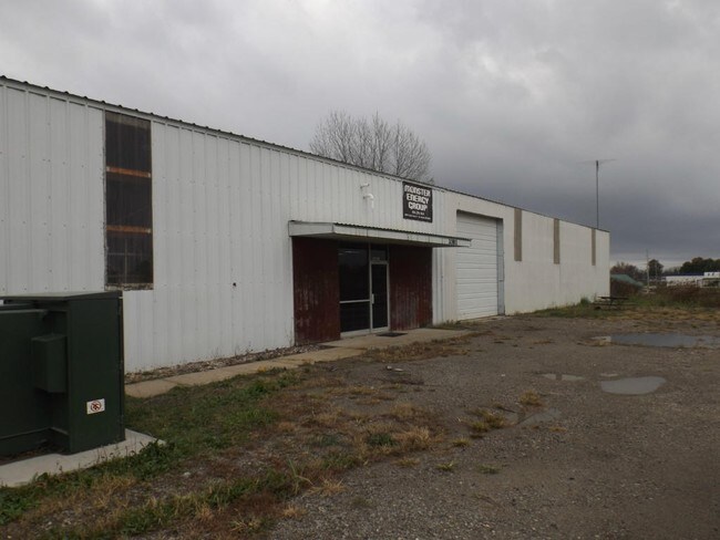
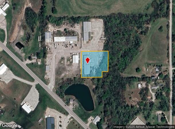
Property Record
20811 State Route K, Saint Joseph, MO 64505
NEARBY LISTINGS FOR SALE OR LEASE
Property Detail
20811 State Route K
St. Joseph, MO-KS
Burkeybile Estates
17-4.0-20-0-00-39.040000
20-58-35 BURKEYBILE ESTATES TRACK OF LAND SOUTH OF LT 4 APP 1.72 AC
Commercialnec
Andrew
X
Missouri
20043C0225D
4
2024
1.72 AC
2025
St Joseph
010100
Kansas City
DEMOGRAPHICS near 20811 State Route K
1 Mile
3 Mile
5 Mile
2024 Total Population
1,018
14,233
49,216
2029 Population
998
13,818
48,160
Pop Growth 2024-2029
(1.96%)
(2.92%)
(2.15%)
Average Age
41
41
40
2024 Total Households
407
5,746
19,826
HH Growth 2024-2029
(1.97%)
(3.01%)
(2.13%)
Median Household Inc
$64,861
$62,322
$47,654
Avg Household Size
2.50
2.40
2.30
2024 Avg HH Vehicles
2.00
2.00
2.00
Median Home Value
$166,311
$169,585
$161,924
Median Year Built
1973
1967
1964
Nearby Places
Map Layers
Map Styles
 Street
 Aerial
- Restaurants
- Banks
- Shops
- Fitness
- Groceries
SALE & LEASE HISTORY
LISTING DATE
SALE/LEASE

Dec 01, 2016
For Sale
Nearby Properties
Address
Land Use
TOTAL SIZE
Lot Size
Zoning
Address
Land Use
TOTAL SIZE
Lot Size
Zoning
31.19 AC
AOR
Address
Land Use
TOTAL SIZE
Lot Size
Zoning
66,905 SF
6.78 AC
CITY
Address
Land Use
TOTAL SIZE
Lot Size
Zoning
33,020 SF
10.11 AC
CITY
Address
Land Use
TOTAL SIZE
Lot Size
Zoning
113,908 SF
2.80 AC
CITY
Address
Land Use
TOTAL SIZE
Lot Size
Zoning
46,050 SF
8.57 AC
CITY
Address
Land Use
TOTAL SIZE
Lot Size
Zoning
60,276 SF
3.17 AC
CITY
Address
Land Use
TOTAL SIZE
Lot Size
Zoning
20,068 SF
Address
Land Use
TOTAL SIZE
Lot Size
Zoning
69,440 SF
3.73 AC
CITY
Address
Land Use
TOTAL SIZE
Lot Size
Zoning
14,500 SF
7.86 AC
CITY
Address
Land Use
TOTAL SIZE
Lot Size
Zoning
73,563 SF
7.02 AC
CITY
Address
Land Use
TOTAL SIZE
Lot Size
Zoning
32,947 SF
5 AC
CITY
Address
Land Use
TOTAL SIZE
Lot Size
Zoning
137,022 SF
11.35 AC
CITY
Address
Land Use
TOTAL SIZE
Lot Size
Zoning
192,666 SF
27.93 AC
CITY
Address
Land Use
TOTAL SIZE
Lot Size
Zoning
58,016 SF
3 AC
CITY
Address
Land Use
TOTAL SIZE
Lot Size
Zoning
12.41 AC
CITY
Address
Land Use
TOTAL SIZE
Lot Size
Zoning
125,301 SF
9.43 AC
CITY
Address
Land Use
TOTAL SIZE
Lot Size
Zoning
47,222 SF
4.81 AC
CITY
Address
Land Use
TOTAL SIZE
Lot Size
Zoning
114,662 SF
14.56 AC
CITY
Address
Land Use
TOTAL SIZE
Lot Size
Zoning
103,803 SF
11.26 AC
CITY
Address
Land Use
TOTAL SIZE
Lot Size
Zoning
29,393 SF
4.30 AC
CITY
Address
Land Use
TOTAL SIZE
Lot Size
Zoning
7,734 SF
5.25 AC
CITY
Address
Land Use
TOTAL SIZE
Lot Size
Zoning
22,088 SF
4.90 AC
CITY
Address
Land Use
TOTAL SIZE
Lot Size
Zoning
50,358 SF
1.28 AC
CITY
Address
Land Use
TOTAL SIZE
Lot Size
Zoning
90,656 SF
12.35 AC
CITY
Address
Land Use
TOTAL SIZE
Lot Size
Zoning
32,510 SF
5.40 AC
CITY
Address
Land Use
TOTAL SIZE
Lot Size
Zoning
7,691 SF
0.57 AC
CITY
Address
Land Use
TOTAL SIZE
Lot Size
Zoning
15,810 SF
3 AC
CITY
Address
Land Use
TOTAL SIZE
Lot Size
Zoning
6.75 AC
CITY
Address
Land Use
TOTAL SIZE
Lot Size
Zoning
45,008 SF
1.79 AC
CITY
Address
Land Use
TOTAL SIZE
Lot Size
Zoning
The World's #1 Commercial Real Estate Marketplace
Connect with us
© 2025 CoStar Group
The information above has been obtained from sources believed reliable. While we do not doubt its accuracy we have not verified it and make no guarantee, warranty or representation about it. It is your responsibility to independently confirm its accuracy and completeness. Any projections, opinions, assumptions, or estimates used are for example only and do not represent the current or future performance of the property. The value of this transaction to you depends on tax and other factors which should be evaluated by your tax, financial, and legal advisors. You and your advisors should conduct a careful, independent investigation of the property to determine to your satisfaction the suitability of the property for your needs.