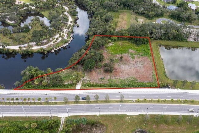
Property Record
2083 W Midway Rd, Fort Pierce, FL 34981
NEARBY LISTINGS FOR SALE OR LEASE
Property Detail
2083 W Midway Rd
Port St Lucie, FL
White City Subdivision
34-03-502-0113-0002
WHITE CITY S/D 04 36 40 THAT PART OF LOT 63 LYG W OF ST LUCIE RIV-LESS TO RD R/W AS IN OR 228-2498- (0.28 AC) (MAP 34/04S) (OR 1658-2072, 2073, 2074: 3823-2758)
Residentialacreage
St Lucie
AE
Florida
12111C0276K
63
2024
0.28 AC
2025
Port St Lucie
381507
Port St Lucie/Fort Pierce
1,354 SF
DEMOGRAPHICS near 2083 W Midway Rd
1 Mile
3 Mile
5 Mile
2024 Total Population
2,650
42,715
113,225
2029 Population
3,192
51,480
136,226
Pop Growth 2024-2029
+ 20.45%
+ 20.52%
+ 20.31%
Average Age
40
42
42
2024 Total Households
966
16,428
43,406
HH Growth 2024-2029
+ 19.67%
+ 20.00%
+ 19.88%
Median Household Inc
$64,166
$56,593
$55,655
Avg Household Size
2.60
2.50
2.50
2024 Avg HH Vehicles
2.00
2.00
2.00
Median Home Value
$336,241
$264,926
$247,906
Median Year Built
1990
1993
1991
Nearby Places
- Restaurants
- Banks
- Shops
- Fitness
- Groceries
SALE & LEASE HISTORY
LISTING DATE
SALE/LEASE

Sep 21, 2022
For Sale
Jun 03, 2025
For Sale
Nearby Properties
Address
Land Use
TOTAL SIZE
Lot Size
Zoning
Address
Land Use
TOTAL SIZE
Lot Size
Zoning
1,124,770 SF
201.84 AC
LIGHT INDU
Address
Land Use
TOTAL SIZE
Lot Size
Zoning
230,294 SF
40.59 AC
Address
Land Use
TOTAL SIZE
Lot Size
Zoning
136,270 SF
49.75 AC
RM-9 COUNT
Address
Land Use
TOTAL SIZE
Lot Size
Zoning
114,420 SF
22.25 AC
PUD
Address
Land Use
TOTAL SIZE
Lot Size
Zoning
54,810 SF
10.14 AC
GENERAL CO
Address
Land Use
TOTAL SIZE
Lot Size
Zoning
101,210 SF
25.17 AC
RM-11 - PS
Address
Land Use
TOTAL SIZE
Lot Size
Zoning
112,457 SF
22.73 AC
PUD
Address
Land Use
TOTAL SIZE
Lot Size
Zoning
106,711 SF
16.73 AC
PUD
Address
Land Use
TOTAL SIZE
Lot Size
Zoning
42,794 SF
2.60 AC
GENERAL CO
Address
Land Use
TOTAL SIZE
Lot Size
Zoning
426,444 SF
180.62 AC
INDUST HEA
Address
Land Use
TOTAL SIZE
Lot Size
Zoning
53,326 SF
4.85 AC
COMM GENRA
Address
Land Use
TOTAL SIZE
Lot Size
Zoning
143.81 AC
INDUST HEA
Address
Land Use
TOTAL SIZE
Lot Size
Zoning
66,333 SF
9.88 AC
PUD
Address
Land Use
TOTAL SIZE
Lot Size
Zoning
76,783 SF
9.48 AC
INDUSTRIAL
Address
Land Use
TOTAL SIZE
Lot Size
Zoning
79,484 SF
26.63 AC
Address
Land Use
TOTAL SIZE
Lot Size
Zoning
155,994 SF
25.13 AC
Address
Land Use
TOTAL SIZE
Lot Size
Zoning
48,561 SF
9.42 AC
COMM GENRA
Address
Land Use
TOTAL SIZE
Lot Size
Zoning
67,518 SF
27.60 AC
INSTITUTIO
Address
Land Use
TOTAL SIZE
Lot Size
Zoning
86,625 SF
11.59 AC
PUD
Address
Land Use
TOTAL SIZE
Lot Size
Zoning
126,754 SF
24.94 AC
GENERAL &
Address
Land Use
TOTAL SIZE
Lot Size
Zoning
131,207 SF
325.14 AC
LIGHT INDU
Address
Land Use
TOTAL SIZE
Lot Size
Zoning
31,078 SF
7.92 AC
GENERAL CO
Address
Land Use
TOTAL SIZE
Lot Size
Zoning
106,188 SF
10.87 AC
GENERAL CO
Address
Land Use
TOTAL SIZE
Lot Size
Zoning
79,536 SF
38 AC
PLANNED NO
Address
Land Use
TOTAL SIZE
Lot Size
Zoning
45,639 SF
6.96 AC
GENERAL CO
Address
Land Use
TOTAL SIZE
Lot Size
Zoning
93,280 SF
13.70 AC
COMM GENRA
Address
Land Use
TOTAL SIZE
Lot Size
Zoning
84,544 SF
9.96 AC
COMM GENRA
Address
Land Use
TOTAL SIZE
Lot Size
Zoning
22,494 SF
7.05 AC
GENERAL CO
Address
Land Use
TOTAL SIZE
Lot Size
Zoning
17,521 SF
5.38 AC
GENERAL CO
Address
Land Use
TOTAL SIZE
Lot Size
Zoning
53,635 SF
33.50 AC
PUD
The World's #1 Commercial Real Estate Marketplace
Connect with us
© 2025 CoStar Group
The information above has been obtained from sources believed reliable. While we do not doubt its accuracy we have not verified it and make no guarantee, warranty or representation about it. It is your responsibility to independently confirm its accuracy and completeness. Any projections, opinions, assumptions, or estimates used are for example only and do not represent the current or future performance of the property. The value of this transaction to you depends on tax and other factors which should be evaluated by your tax, financial, and legal advisors. You and your advisors should conduct a careful, independent investigation of the property to determine to your satisfaction the suitability of the property for your needs.