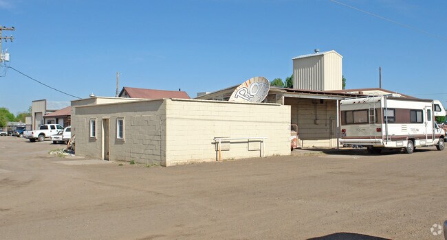
Property Record
2085 4Th Ave E, Twin Falls, ID 83301

Property Detail
2085 4Th Ave E
RPT5041000011AA
TWIN FALLS SNYDER TRACT LOT 11, EXC SW 90 X 110 & EXC SE 90 X 90; W 50 OF S12 LOT 12 (15-10-17 SE)
Autorepair
TWIN FALLS
M-1
Idaho
A Areas with a 1% annual chance of flooding and a 26% chance of flooding over the life of a 30-year mortgage.
11-12
2025
4.79 AC
2025
Other Market Areas
001002
Twin Falls, ID
17,288 SF
NEARBY LISTINGS FOR SALE OR LEASE
DEMOGRAPHICS near 2085 4Th Ave E
1 mile
3 mile
5 mile
2024 Total Population
10,336
49,800
70,786
2029 Population
10,776
52,434
74,777
Pop Growth 2024-2029
+ 4.26%
+ 5.29%
+ 5.64%
Average Age
37
38
38
2024 Total Households
4,002
18,738
25,835
HH Growth 2024-2029
+ 4.37%
+ 5.40%
+ 5.73%
Median Household Inc
$64,715
$62,624
$67,388
Avg Household Size
2.50
2.60
2.60
2024 Avg HH Vehicles
2.00
2.00
2.00
Median Home Value
$297,847
$317,491
$332,342
Median Year Built
1975
1978
1987
Nearby Places
Map Layers
Map Styles
 Street
 Aerial
Transit
 Traffic
 Biking
Places
Listings with unknown addresses are not visible on the map
- Restaurants
- Banks
- Shops
- Fitness
- Groceries
Nearby Properties
Address
Land Use
TOTAL SIZE
Lot Size
Zoning
Address
Land Use
TOTAL SIZE
Lot Size
Zoning
917,616 SF
143.88 AC
M-2
Address
Land Use
TOTAL SIZE
Lot Size
Zoning
259,424 SF
89.44 AC
M-2
Address
Land Use
TOTAL SIZE
Lot Size
Zoning
38,811 SF
40.92 AC
C-1
Address
Land Use
TOTAL SIZE
Lot Size
Zoning
6,384 SF
5.89 AC
M-2
Address
Land Use
TOTAL SIZE
Lot Size
Zoning
382,261 SF
11.44 AC
M-2
Address
Land Use
TOTAL SIZE
Lot Size
Zoning
8.53 AC
C-1
Address
Land Use
TOTAL SIZE
Lot Size
Zoning
57,683 SF
36.64 AC
Address
Land Use
TOTAL SIZE
Lot Size
Zoning
167,708 SF
14.90 AC
C-1
Address
Land Use
TOTAL SIZE
Lot Size
Zoning
160,432 SF
11.25 AC
C-1
Address
Land Use
TOTAL SIZE
Lot Size
Zoning
137,048 SF
12.66 AC
C-1
Address
Land Use
TOTAL SIZE
Lot Size
Zoning
240,740 SF
6.74 AC
M-2
Address
Land Use
TOTAL SIZE
Lot Size
Zoning
91,588 SF
3.16 AC
C-1
Address
Land Use
TOTAL SIZE
Lot Size
Zoning
116,676 SF
12.13 AC
C-1
Address
Land Use
TOTAL SIZE
Lot Size
Zoning
9,440 SF
7.05 AC
R-6
Address
Land Use
TOTAL SIZE
Lot Size
Zoning
114,844 SF
7.70 AC
C-1
Address
Land Use
TOTAL SIZE
Lot Size
Zoning
127,520 SF
16.82 AC
M-2
Address
Land Use
TOTAL SIZE
Lot Size
Zoning
20,016 SF
4.40 AC
R-6
Address
Land Use
TOTAL SIZE
Lot Size
Zoning
40,730 SF
0.36 AC
O-T
Address
Land Use
TOTAL SIZE
Lot Size
Zoning
78,849 SF
18.66 AC
M-2
Address
Land Use
TOTAL SIZE
Lot Size
Zoning
29,988 SF
3.80 AC
Address
Land Use
TOTAL SIZE
Lot Size
Zoning
9,220 SF
5.92 AC
R-4
Address
Land Use
TOTAL SIZE
Lot Size
Zoning
233,304 SF
6.01 AC
M-2
Address
Land Use
TOTAL SIZE
Lot Size
Zoning
54,380 SF
2.23 AC
C-1
Address
Land Use
TOTAL SIZE
Lot Size
Zoning
94,366 SF
9.85 AC
M-2
Address
Land Use
TOTAL SIZE
Lot Size
Zoning
52,095 SF
0.22 AC
C-B
Address
Land Use
TOTAL SIZE
Lot Size
Zoning
88,314 SF
8.15 AC
C-1
Address
Land Use
TOTAL SIZE
Lot Size
Zoning
51,109 SF
0.93 AC
C-1
Address
Land Use
TOTAL SIZE
Lot Size
Zoning
53,953 SF
3.98 AC
R-6
Address
Land Use
TOTAL SIZE
Lot Size
Zoning
71,546 SF
6.65 AC
C-1
The World's #1 Commercial Real Estate Marketplace
Connect with us
© 2026 CoStar Group
The information above has been obtained from sources believed reliable. While we do not doubt its accuracy we have not verified it and make no guarantee, warranty or representation about it. It is your responsibility to independently confirm its accuracy and completeness. Any projections, opinions, assumptions, or estimates used are for example only and do not represent the current or future performance of the property. The value of this transaction to you depends on tax and other factors which should be evaluated by your tax, financial, and legal advisors. You and your advisors should conduct a careful, independent investigation of the property to determine to your satisfaction the suitability of the property for your needs.