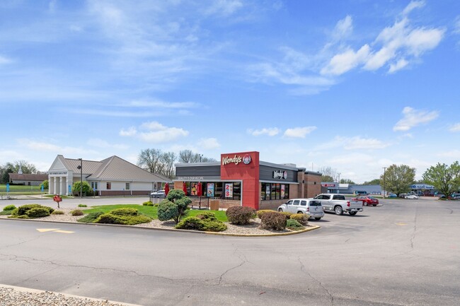
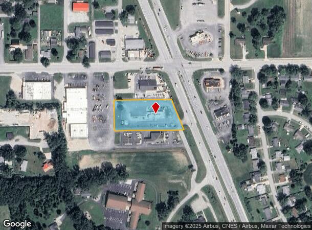
Property Record
2085 N Reed Rd, Kokomo, IN 46901

NEARBY LISTINGS FOR SALE OR LEASE
Property Detail
2085 N Reed Rd
Kokomo, IN
Bowyers Minor Sub
34-04-30-201-022.000-002
BOWYERS MINOR S/D A S/D OF PT LOTS 1 & 3 & URICH MINOR S/D PT LOT 2 & URICH MINOR S/D PT LOT 1 1.49 AC
Restaurantdrivein
Howard
X
Indiana
18067C0100C
1,3,2
2023
1.27 AC
2024
Lafayette/Kokomo
000300
Other Market Areas
3,062 SF
DEMOGRAPHICS near 2085 N Reed Rd
1 Mile
3 Mile
5 Mile
2024 Total Population
5,296
36,459
59,676
2029 Population
5,350
36,954
59,842
Pop Growth 2024-2029
+ 1.02%
+ 1.36%
+ 0.28%
Average Age
40
40
41
2024 Total Households
2,251
15,852
26,262
HH Growth 2024-2029
+ 0.93%
+ 1.33%
+ 0.21%
Median Household Inc
$42,131
$43,761
$50,346
Avg Household Size
2.30
2.20
2.20
2024 Avg HH Vehicles
2.00
2.00
2.00
Median Home Value
$56,064
$83,511
$125,722
Median Year Built
1956
1955
1965
Nearby Places
Map Layers
Map Styles
 Street
 Aerial
- Restaurants
- Banks
- Shops
- Fitness
- Groceries
SALE & LEASE HISTORY
LISTING DATE
SALE/LEASE

May 07, 2025
For Sale
Nearby Properties
Address
Land Use
TOTAL SIZE
Lot Size
Zoning
Address
Land Use
TOTAL SIZE
Lot Size
Zoning
1,415,366 SF
0.03 AC
Address
Land Use
TOTAL SIZE
Lot Size
Zoning
11,490,970 SF
0.02 AC
Address
Land Use
TOTAL SIZE
Lot Size
Zoning
399,910 SF
131 SF
Address
Land Use
TOTAL SIZE
Lot Size
Zoning
414,424 SF
87 SF
Address
Land Use
TOTAL SIZE
Lot Size
Zoning
165,418 SF
1.97 AC
Address
Land Use
TOTAL SIZE
Lot Size
Zoning
212,590 SF
87 SF
Address
Land Use
TOTAL SIZE
Lot Size
Zoning
74,096 SF
1.18 AC
Address
Land Use
TOTAL SIZE
Lot Size
Zoning
227,171 SF
87 SF
Address
Land Use
TOTAL SIZE
Lot Size
Zoning
188,016 SF
44 SF
Address
Land Use
TOTAL SIZE
Lot Size
Zoning
116,821 SF
44 SF
Address
Land Use
TOTAL SIZE
Lot Size
Zoning
101,088 SF
44 SF
Address
Land Use
TOTAL SIZE
Lot Size
Zoning
0.01 AC
Address
Land Use
TOTAL SIZE
Lot Size
Zoning
119,966 SF
44 SF
Address
Land Use
TOTAL SIZE
Lot Size
Zoning
158,656 SF
44 SF
Address
Land Use
TOTAL SIZE
Lot Size
Zoning
89,717 SF
87 SF
Address
Land Use
TOTAL SIZE
Lot Size
Zoning
4,976 SF
131 SF
Address
Land Use
TOTAL SIZE
Lot Size
Zoning
133,817 SF
87 SF
Address
Land Use
TOTAL SIZE
Lot Size
Zoning
133,851 SF
87 SF
Address
Land Use
TOTAL SIZE
Lot Size
Zoning
159,792 SF
44 SF
Address
Land Use
TOTAL SIZE
Lot Size
Zoning
71,832 SF
1.48 AC
Address
Land Use
TOTAL SIZE
Lot Size
Zoning
28,188 SF
44 SF
Address
Land Use
TOTAL SIZE
Lot Size
Zoning
89,075 SF
44 SF
Address
Land Use
TOTAL SIZE
Lot Size
Zoning
64,140 SF
2.26 AC
Address
Land Use
TOTAL SIZE
Lot Size
Zoning
125,240 SF
87 SF
Address
Land Use
TOTAL SIZE
Lot Size
Zoning
77,569 SF
44 SF
Address
Land Use
TOTAL SIZE
Lot Size
Zoning
67,200 SF
3.35 AC
Address
Land Use
TOTAL SIZE
Lot Size
Zoning
85,512 SF
44 SF
Address
Land Use
TOTAL SIZE
Lot Size
Zoning
103,664 SF
44 SF
Address
Land Use
TOTAL SIZE
Lot Size
Zoning
49,289 SF
0.59 AC
Address
Land Use
TOTAL SIZE
Lot Size
Zoning
48,565 SF
44 SF
The World's #1 Commercial Real Estate Marketplace
Connect with us
© 2025 CoStar Group
The information above has been obtained from sources believed reliable. While we do not doubt its accuracy we have not verified it and make no guarantee, warranty or representation about it. It is your responsibility to independently confirm its accuracy and completeness. Any projections, opinions, assumptions, or estimates used are for example only and do not represent the current or future performance of the property. The value of this transaction to you depends on tax and other factors which should be evaluated by your tax, financial, and legal advisors. You and your advisors should conduct a careful, independent investigation of the property to determine to your satisfaction the suitability of the property for your needs.