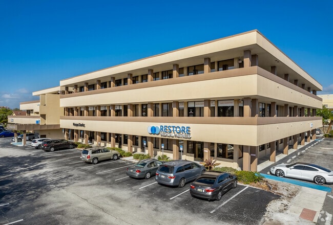
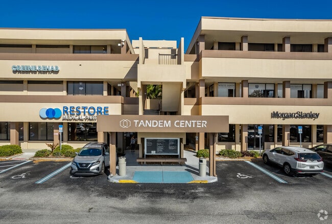
Property Record
2085 S Tamiami Trl, Venice, FL 34293
Current Lease Availabilities
NEARBY LISTINGS FOR SALE OR LEASE
Property Detail
2085 S Tamiami Trl
North Port-Sarasota-Bradenton, FL
Not Part Of A Subdivision
0450-03-0003
UNITS 201 202 203 222 THRU 227 246 THRU 251 270 271 & 272 TANDEM CENTER CONDOMINIUM OFFICES
Commercialacreage
Sarasota
AE
Florida
12115C0341G
0.92 AC
2024
Sarasota
2025
Tampa/St Petersburg
002404
DEMOGRAPHICS near 2085 S Tamiami Trl
1 Mile
3 Mile
5 Mile
2024 Total Population
9,722
46,053
85,689
2029 Population
11,472
53,776
99,628
Pop Growth 2024-2029
+ 18.00%
+ 16.77%
+ 16.27%
Average Age
64
60
58
2024 Total Households
5,425
24,154
43,266
HH Growth 2024-2029
+ 18.08%
+ 16.90%
+ 16.35%
Median Household Inc
$57,006
$62,992
$67,956
Avg Household Size
1.70
1.80
1.90
2024 Avg HH Vehicles
1.00
1.00
2.00
Median Home Value
$397,058
$304,135
$318,704
Median Year Built
1973
1979
1985
Nearby Places
Map Layers
Map Styles
 Street
 Aerial
- Restaurants
- Banks
- Shops
- Fitness
- Groceries
PUBLIC TRANSPORTATION
AIRPORT
Sarasota/Bradenton International
DRIVE
WALK
Distance
Sarasota/Bradenton International
48 min
34.5 mi
Punta Gorda
DRIVE
WALK
Distance
Punta Gorda
49 min
38.3 mi
Nearby Properties
Address
Land Use
TOTAL SIZE
Lot Size
Zoning
Address
Land Use
TOTAL SIZE
Lot Size
Zoning
565,625 SF
15.61 AC
ST2A
Address
Land Use
TOTAL SIZE
Lot Size
Zoning
421,272 SF
31.96 AC
PUD
Address
Land Use
TOTAL SIZE
Lot Size
Zoning
251,872 SF
25.01 AC
RMF2
Address
Land Use
TOTAL SIZE
Lot Size
Zoning
191,373 SF
23.12 AC
RMF2
Address
Land Use
TOTAL SIZE
Lot Size
Zoning
173,966 SF
17 AC
CG
Address
Land Use
TOTAL SIZE
Lot Size
Zoning
149,834 SF
36.95 AC
GU
Address
Land Use
TOTAL SIZE
Lot Size
Zoning
223,397 SF
453.78 AC
G
Address
Land Use
TOTAL SIZE
Lot Size
Zoning
159,759 SF
12.60 AC
RMF3
Address
Land Use
TOTAL SIZE
Lot Size
Zoning
201,992 SF
22.45 AC
CG
Address
Land Use
TOTAL SIZE
Lot Size
Zoning
146,990 SF
8.90 AC
CG
Address
Land Use
TOTAL SIZE
Lot Size
Zoning
63,549 SF
6.26 AC
OPI
Address
Land Use
TOTAL SIZE
Lot Size
Zoning
98,113 SF
12.05 AC
CSC
Address
Land Use
TOTAL SIZE
Lot Size
Zoning
111,306 SF
9.35 AC
CSC
Address
Land Use
TOTAL SIZE
Lot Size
Zoning
138,547 SF
18.63 AC
CSC
Address
Land Use
TOTAL SIZE
Lot Size
Zoning
66,899 SF
30.10 AC
GU
Address
Land Use
TOTAL SIZE
Lot Size
Zoning
121,747 SF
17.54 AC
OUE1
Address
Land Use
TOTAL SIZE
Lot Size
Zoning
112,415 SF
8.77 AC
CSC
Address
Land Use
TOTAL SIZE
Lot Size
Zoning
76,247 SF
13.89 AC
CG
Address
Land Use
TOTAL SIZE
Lot Size
Zoning
66.78 AC
RMF1
Address
Land Use
TOTAL SIZE
Lot Size
Zoning
8,040 SF
46.23 AC
RMH
Address
Land Use
TOTAL SIZE
Lot Size
Zoning
92,802 SF
4.78 AC
CN
Address
Land Use
TOTAL SIZE
Lot Size
Zoning
3,447 SF
65.66 AC
ROS
Address
Land Use
TOTAL SIZE
Lot Size
Zoning
101,496 SF
19.08 AC
CG
Address
Land Use
TOTAL SIZE
Lot Size
Zoning
119,222 SF
12.47 AC
CG
Address
Land Use
TOTAL SIZE
Lot Size
Zoning
94,453 SF
10.11 AC
CG
Address
Land Use
TOTAL SIZE
Lot Size
Zoning
79,048 SF
6.92 AC
CI
Address
Land Use
TOTAL SIZE
Lot Size
Zoning
114,693 SF
15.16 AC
PUD
Address
Land Use
TOTAL SIZE
Lot Size
Zoning
30,560 SF
9.92 AC
G
Address
Land Use
TOTAL SIZE
Lot Size
Zoning
121,850 SF
8.98 AC
CG
Address
Land Use
TOTAL SIZE
Lot Size
Zoning
61,332 SF
8.25 AC
ST2
The World's #1 Commercial Real Estate Marketplace
Connect with us
© 2025 CoStar Group
The information above has been obtained from sources believed reliable. While we do not doubt its accuracy we have not verified it and make no guarantee, warranty or representation about it. It is your responsibility to independently confirm its accuracy and completeness. Any projections, opinions, assumptions, or estimates used are for example only and do not represent the current or future performance of the property. The value of this transaction to you depends on tax and other factors which should be evaluated by your tax, financial, and legal advisors. You and your advisors should conduct a careful, independent investigation of the property to determine to your satisfaction the suitability of the property for your needs.