Property Record
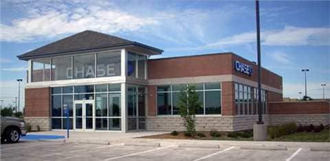
20851 Hall Rd, Macomb, MI 48044


Property Detail
20851 Hall Rd
20-08-34-300-031
T3N, R13E, SEC 34; COMM AT SW COR SEC 34; TH N00*22'16"E 292.22 FT, TH S89*37'44"E 33.0 FT, TH S44*41'45"E 28.24 FT, TH
Centrallyassessed
MACOMB
C2
Michigan
A Areas with a 1% annual chance of flooding and a 26% chance of flooding over the life of a 30-year mortgage.
1.07 AC
2025
Macomb East
2025
Detroit
224202
Detroit-Warren-Dearborn, MI
4,180 SF
NEARBY LISTINGS FOR SALE OR LEASE
DEMOGRAPHICS near 20851 Hall Rd
1 mile
3 mile
5 mile
2025 Total Population
15,471
101,116
227,698
2030 Population
15,548
101,857
230,090
Pop Growth 2025-2030
+ 0.50%
+ 0.73%
+ 1.05%
Average Age
39
41
42
2025 Total Households
6,579
40,005
91,603
HH Growth 2025-2030
+ 0.47%
+ 0.84%
+ 1.07%
Median Household Inc
$85,018
$87,655
$84,044
Avg Household Size
2.30
2.50
2.40
2025 Avg HH Vehicles
2.00
2.00
2.00
Median Home Value
$313,893
$316,455
$293,134
Median Year Built
1996
1992
1988
Nearby Places
Map Layers
Map Styles
 Street
 Aerial
Transit
 Traffic
 Biking
Places
Listings with unknown addresses are not visible on the map
- Restaurants
- Banks
- Shops
- Fitness
- Groceries
PUBLIC TRANSPORTATION
AIRPORT
Windsor International
Drive
Walk
Distance
Windsor International
65 min
40.7 mi
SALE & LEASE HISTORY
LISTING DATE
SALE/LEASE

Dec 18, 2019
For Lease
Apr 25, 2024
For Lease
Nearby Properties
Address
Land Use
TOTAL SIZE
Lot Size
Zoning
Address
Land Use
TOTAL SIZE
Lot Size
Zoning
426,076 SF
42.79 AC
B-4
Address
Land Use
TOTAL SIZE
Lot Size
Zoning
122.50 AC
RML
Address
Land Use
TOTAL SIZE
Lot Size
Zoning
35 AC
RML
Address
Land Use
TOTAL SIZE
Lot Size
Zoning
20,560 SF
37.09 AC
R2
Address
Land Use
TOTAL SIZE
Lot Size
Zoning
20,891 SF
289.61 AC
R3
Address
Land Use
TOTAL SIZE
Lot Size
Zoning
401,014 SF
32.54 AC
RML
Address
Land Use
TOTAL SIZE
Lot Size
Zoning
40.39 AC
RML
Address
Land Use
TOTAL SIZE
Lot Size
Zoning
22.52 AC
RMH
Address
Land Use
TOTAL SIZE
Lot Size
Zoning
404,160 SF
22.52 AC
I-1
Address
Land Use
TOTAL SIZE
Lot Size
Zoning
182,708 SF
10.69 AC
RMH
Address
Land Use
TOTAL SIZE
Lot Size
Zoning
44.65 AC
RML
Address
Land Use
TOTAL SIZE
Lot Size
Zoning
182,102 SF
11.04 AC
SP-1
Address
Land Use
TOTAL SIZE
Lot Size
Zoning
25.14 AC
RML
Address
Land Use
TOTAL SIZE
Lot Size
Zoning
20.27 AC
RML
Address
Land Use
TOTAL SIZE
Lot Size
Zoning
15.94 AC
RMH
Address
Land Use
TOTAL SIZE
Lot Size
Zoning
15.90 AC
RML
Address
Land Use
TOTAL SIZE
Lot Size
Zoning
26.92 AC
RML
Address
Land Use
TOTAL SIZE
Lot Size
Zoning
79,504 SF
SP-2
Address
Land Use
TOTAL SIZE
Lot Size
Zoning
670,448 SF
37.23 AC
L-2
Address
Land Use
TOTAL SIZE
Lot Size
Zoning
196,459 SF
19.18 AC
I-1
Address
Land Use
TOTAL SIZE
Lot Size
Zoning
42,385 SF
25.55 AC
B-2
Address
Land Use
TOTAL SIZE
Lot Size
Zoning
37.44 AC
RML
Address
Land Use
TOTAL SIZE
Lot Size
Zoning
45,000 SF
7.58 AC
B-4
Address
Land Use
TOTAL SIZE
Lot Size
Zoning
72,572 SF
10 AC
B-3
Address
Land Use
TOTAL SIZE
Lot Size
Zoning
134,327 SF
10.02 AC
I-1
Address
Land Use
TOTAL SIZE
Lot Size
Zoning
175,143 SF
22.87 AC
B-4
Address
Land Use
TOTAL SIZE
Lot Size
Zoning
94,332 SF
3.47 AC
B-3
Address
Land Use
TOTAL SIZE
Lot Size
Zoning
4.72 AC
SP-1
Address
Land Use
TOTAL SIZE
Lot Size
Zoning
148,446 SF
10.01 AC
RMH
Address
Land Use
TOTAL SIZE
Lot Size
Zoning
600 SF
18.79 AC
R2L
The World's #1 Commercial Real Estate Marketplace
Connect with us
© 2026 CoStar Group
The information above has been obtained from sources believed reliable. While we do not doubt its accuracy we have not verified it and make no guarantee, warranty or representation about it. It is your responsibility to independently confirm its accuracy and completeness. Any projections, opinions, assumptions, or estimates used are for example only and do not represent the current or future performance of the property. The value of this transaction to you depends on tax and other factors which should be evaluated by your tax, financial, and legal advisors. You and your advisors should conduct a careful, independent investigation of the property to determine to your satisfaction the suitability of the property for your needs.