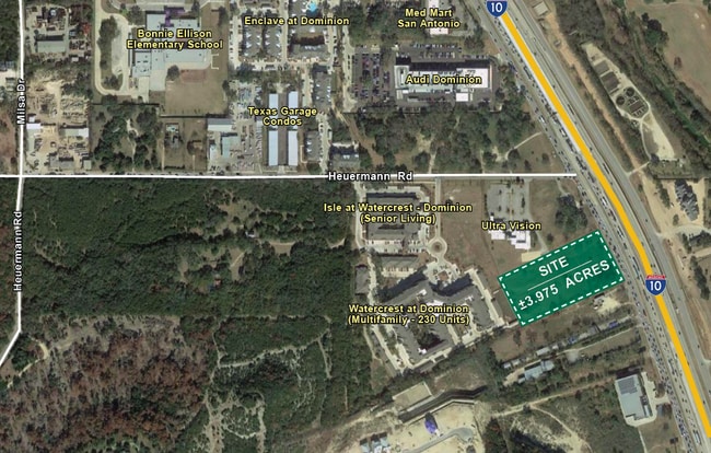
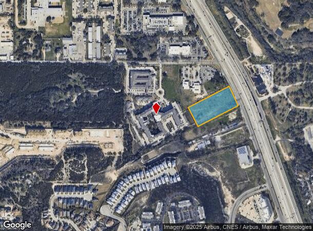
Property Record
20865 W Interstate 10, San Antonio, TX 78257
NEARBY LISTINGS FOR SALE OR LEASE
Property Detail
20865 W Interstate 10
San Antonio-New Braunfels, TX
Conv A/S Code
18333-003-0020
NCB 18333 BLK 3 LOT SE IRR 284.86 FT OF 2 2015) SPLITS PER DEEDS 16854/2489 & 16854/2494
Commercialnec
Bexar
X
Texas
48029C0115F
38
2024
3.96 AC
2025
Far Northwest
181902
San Antonio
1,746 SF
DEMOGRAPHICS near 20865 W Interstate 10
1 Mile
3 Mile
5 Mile
2024 Total Population
5,896
30,678
94,911
2029 Population
6,405
33,248
102,210
Pop Growth 2024-2029
+ 8.63%
+ 8.38%
+ 7.69%
Average Age
38
37
36
2024 Total Households
2,786
13,329
37,743
HH Growth 2024-2029
+ 8.83%
+ 8.66%
+ 8.02%
Median Household Inc
$84,980
$86,758
$88,050
Avg Household Size
2.10
2.30
2.40
2024 Avg HH Vehicles
2.00
2.00
2.00
Median Home Value
$650,431
$476,550
$390,385
Median Year Built
2011
2010
2008
Nearby Places
Map Layers
Map Styles
 Street
 Aerial
- Restaurants
- Banks
- Shops
- Fitness
- Groceries
PUBLIC TRANSPORTATION
AIRPORT
San Antonio International
DRIVE
WALK
Distance
San Antonio International
16 min
15.7 mi
Freight Ports
Calhoun Port
DRIVE
WALK
Distance
Calhoun Port
1 min
141.0 mi
SALE & LEASE HISTORY
LISTING DATE
SALE/LEASE

Sep 24, 2016
For Sale
Mar 26, 2020
For Sale
Jan 29, 2018
For Sale
Nearby Properties
Address
Land Use
TOTAL SIZE
Lot Size
Zoning
Address
Land Use
TOTAL SIZE
Lot Size
Zoning
23,242.10 AC
Address
Land Use
TOTAL SIZE
Lot Size
Zoning
437,060 SF
91.31 AC
Address
Land Use
TOTAL SIZE
Lot Size
Zoning
405,133 SF
16.41 AC
Address
Land Use
TOTAL SIZE
Lot Size
Zoning
538,895 SF
54.58 AC
Address
Land Use
TOTAL SIZE
Lot Size
Zoning
335,841 SF
33.70 AC
Address
Land Use
TOTAL SIZE
Lot Size
Zoning
538,895 SF
60.25 AC
Address
Land Use
TOTAL SIZE
Lot Size
Zoning
509,312 SF
43.63 AC
Address
Land Use
TOTAL SIZE
Lot Size
Zoning
384,503 SF
15.95 AC
Address
Land Use
TOTAL SIZE
Lot Size
Zoning
391,367 SF
11.36 AC
Address
Land Use
TOTAL SIZE
Lot Size
Zoning
13,128 SF
5.23 AC
Address
Land Use
TOTAL SIZE
Lot Size
Zoning
21,852 SF
5.25 AC
Address
Land Use
TOTAL SIZE
Lot Size
Zoning
481,373 SF
44.28 AC
Address
Land Use
TOTAL SIZE
Lot Size
Zoning
10,622 SF
8.01 AC
Address
Land Use
TOTAL SIZE
Lot Size
Zoning
375,702 SF
10 AC
Address
Land Use
TOTAL SIZE
Lot Size
Zoning
329,050 SF
17.10 AC
Address
Land Use
TOTAL SIZE
Lot Size
Zoning
515,812 SF
200.45 AC
Address
Land Use
TOTAL SIZE
Lot Size
Zoning
329,035 SF
21.28 AC
Address
Land Use
TOTAL SIZE
Lot Size
Zoning
309,429 SF
5.17 AC
Address
Land Use
TOTAL SIZE
Lot Size
Zoning
331,741 SF
16.53 AC
Address
Land Use
TOTAL SIZE
Lot Size
Zoning
312,150 SF
22.60 AC
Address
Land Use
TOTAL SIZE
Lot Size
Zoning
260,620 SF
10.21 AC
Address
Land Use
TOTAL SIZE
Lot Size
Zoning
277,720 SF
16.97 AC
Address
Land Use
TOTAL SIZE
Lot Size
Zoning
272,094 SF
16.90 AC
Address
Land Use
TOTAL SIZE
Lot Size
Zoning
270,295 SF
14.07 AC
Address
Land Use
TOTAL SIZE
Lot Size
Zoning
249,241 SF
28.10 AC
Address
Land Use
TOTAL SIZE
Lot Size
Zoning
269,056 SF
12.13 AC
Address
Land Use
TOTAL SIZE
Lot Size
Zoning
319,253 SF
23.95 AC
Address
Land Use
TOTAL SIZE
Lot Size
Zoning
300,670 SF
15.37 AC
Address
Land Use
TOTAL SIZE
Lot Size
Zoning
146,208 SF
12.84 AC
Address
Land Use
TOTAL SIZE
Lot Size
Zoning
204,108 SF
33.27 AC
The World's #1 Commercial Real Estate Marketplace
Connect with us
© 2025 CoStar Group
The information above has been obtained from sources believed reliable. While we do not doubt its accuracy we have not verified it and make no guarantee, warranty or representation about it. It is your responsibility to independently confirm its accuracy and completeness. Any projections, opinions, assumptions, or estimates used are for example only and do not represent the current or future performance of the property. The value of this transaction to you depends on tax and other factors which should be evaluated by your tax, financial, and legal advisors. You and your advisors should conduct a careful, independent investigation of the property to determine to your satisfaction the suitability of the property for your needs.