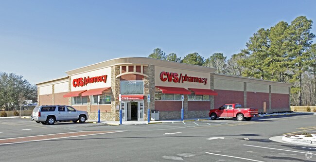
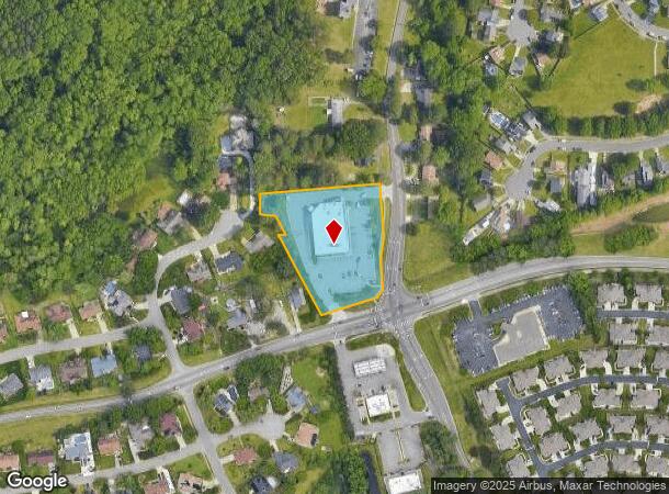
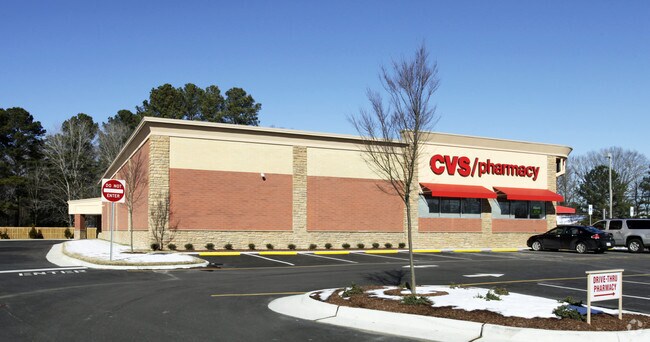
Property Record
2089 Salem Rd, Virginia Beach, VA 23456
NEARBY LISTINGS FOR SALE OR LEASE
Property Detail
2089 Salem Rd
1474-88-8179
Salem
Supermarket
SALEM PARCEL A-1 2.110 ACS
X
Virginia Beach
5155310113F
Virginia
2024
2.11 AC
2025
Princess Anne
046216
Hampton Roads
13,350 SF
Virginia Beach-Chesapeake-Norfolk, VA-NC
DEMOGRAPHICS near 2089 Salem Rd
1 Mile
3 Mile
5 Mile
2024 Total Population
11,871
81,397
208,015
2029 Population
11,673
80,328
206,190
Pop Growth 2024-2029
(1.67%)
(1.31%)
(0.88%)
Average Age
38
38
39
2024 Total Households
3,910
28,398
75,943
HH Growth 2024-2029
(1.82%)
(1.45%)
(1.00%)
Median Household Inc
$109,890
$91,871
$86,710
Avg Household Size
3.00
2.80
2.70
2024 Avg HH Vehicles
3.00
2.00
2.00
Median Home Value
$336,117
$293,782
$294,006
Median Year Built
1989
1986
1985
Nearby Places
Map Layers
Map Styles
 Street
 Aerial
- Restaurants
- Banks
- Shops
- Fitness
- Groceries
PUBLIC TRANSPORTATION
AIRPORT
Norfolk International
DRIVE
WALK
Distance
Norfolk International
25 min
13.7 mi
Newport News/Williamsburg International
DRIVE
WALK
Distance
Newport News/Williamsburg International
60 min
39.2 mi
Freight Ports
Virginia Port Authority - Portsmouth
DRIVE
WALK
Distance
Virginia Port Authority - Portsmouth
33 min
16.7 mi
SALE & LEASE HISTORY
LISTING DATE
SALE/LEASE

Sep 09, 2019
For Sale
Nearby Properties
Address
Land Use
TOTAL SIZE
Lot Size
Zoning
Address
Land Use
TOTAL SIZE
Lot Size
Zoning
693,172 SF
O2
Address
Land Use
TOTAL SIZE
Lot Size
Zoning
536,135 SF
115.04 AC
P1
Address
Land Use
TOTAL SIZE
Lot Size
Zoning
1 SF
44.31 AC
A18
Address
Land Use
TOTAL SIZE
Lot Size
Zoning
23.06 AC
A36
Address
Land Use
TOTAL SIZE
Lot Size
Zoning
4 SF
19.85 AC
A12
Address
Land Use
TOTAL SIZE
Lot Size
Zoning
153 SF
88.33 AC
R75
Address
Land Use
TOTAL SIZE
Lot Size
Zoning
309,512 SF
65.15 AC
P1
Address
Land Use
TOTAL SIZE
Lot Size
Zoning
349,667 SF
35.30 AC
Address
Land Use
TOTAL SIZE
Lot Size
Zoning
289,581 SF
49.99 AC
R5D
Address
Land Use
TOTAL SIZE
Lot Size
Zoning
1 SF
18.64 AC
PDH1
Address
Land Use
TOTAL SIZE
Lot Size
Zoning
366,189 SF
55.78 AC
B2
Address
Land Use
TOTAL SIZE
Lot Size
Zoning
1 SF
16.15 AC
PDH1
Address
Land Use
TOTAL SIZE
Lot Size
Zoning
252,686 SF
50.05 AC
PDH1
Address
Land Use
TOTAL SIZE
Lot Size
Zoning
174,868 SF
65.46 AC
AG1
Address
Land Use
TOTAL SIZE
Lot Size
Zoning
1 SF
10.64 AC
PDH1
Address
Land Use
TOTAL SIZE
Lot Size
Zoning
128,577 SF
15.28 AC
I1
Address
Land Use
TOTAL SIZE
Lot Size
Zoning
259,135 SF
50.10 AC
R10
Address
Land Use
TOTAL SIZE
Lot Size
Zoning
68,731 SF
5.80 AC
Address
Land Use
TOTAL SIZE
Lot Size
Zoning
1 SF
9.90 AC
PDH1
Address
Land Use
TOTAL SIZE
Lot Size
Zoning
86,174 SF
33.02 AC
R5D
Address
Land Use
TOTAL SIZE
Lot Size
Zoning
135,237 SF
20.83 AC
B2
Address
Land Use
TOTAL SIZE
Lot Size
Zoning
211,322 SF
40.10 AC
I1
Address
Land Use
TOTAL SIZE
Lot Size
Zoning
232,800 SF
24.42 AC
I1
Address
Land Use
TOTAL SIZE
Lot Size
Zoning
202,746 SF
77.46 AC
O2
Address
Land Use
TOTAL SIZE
Lot Size
Zoning
2,926 SF
221.80 AC
AG1
Address
Land Use
TOTAL SIZE
Lot Size
Zoning
196,053 SF
12.75 AC
I1
Address
Land Use
TOTAL SIZE
Lot Size
Zoning
186,551 SF
34.16 AC
R10
Address
Land Use
TOTAL SIZE
Lot Size
Zoning
88,860 SF
13.75 AC
PDH1
Address
Land Use
TOTAL SIZE
Lot Size
Zoning
99,399 SF
31.37 AC
R10
Address
Land Use
TOTAL SIZE
Lot Size
Zoning
69,022 SF
9.37 AC
I1
The World's #1 Commercial Real Estate Marketplace
Connect with us
© 2026 CoStar Group
The information above has been obtained from sources believed reliable. While we do not doubt its accuracy we have not verified it and make no guarantee, warranty or representation about it. It is your responsibility to independently confirm its accuracy and completeness. Any projections, opinions, assumptions, or estimates used are for example only and do not represent the current or future performance of the property. The value of this transaction to you depends on tax and other factors which should be evaluated by your tax, financial, and legal advisors. You and your advisors should conduct a careful, independent investigation of the property to determine to your satisfaction the suitability of the property for your needs.