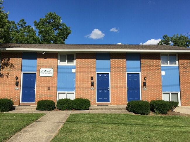
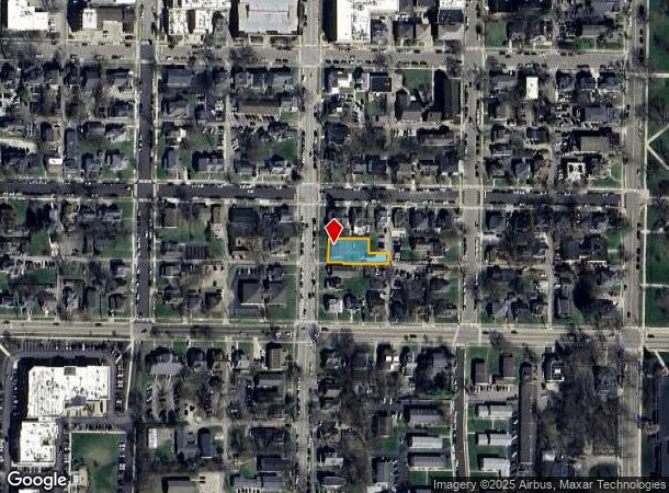
Property Record
209 S Main St, Oxford, OH 45056

NEARBY LISTINGS FOR SALE OR LEASE
-
-
View all Oxford listings for sale on LoopNet.com
Property Detail
209 S Main St
Cincinnati, OH-KY-IN
Oxford
H4100-003-000-116
Butler
Triplex
Ohio
X
0.21 AC
39017C0038F
Butler County
2,900 SF
Cincinnati/Dayton
DEMOGRAPHICS near 209 S Main St
1 Mile
3 Mile
5 Mile
2024 Total Population
17,895
24,604
28,055
2029 Population
18,394
25,192
28,598
Pop Growth 2024-2029
+ 2.79%
+ 2.39%
+ 1.94%
Average Age
27
30
32
2024 Total Households
4,883
7,758
9,069
HH Growth 2024-2029
+ 2.93%
+ 2.35%
+ 1.81%
Median Household Inc
$32,928
$44,138
$47,974
Avg Household Size
2.30
2.30
2.40
2024 Avg HH Vehicles
2.00
2.00
2.00
Median Home Value
$257,219
$261,218
$261,255
Median Year Built
1984
1984
1982
Nearby Places
Map Layers
Map Styles
 Street
 Aerial
- Restaurants
- Banks
- Shops
- Fitness
- Groceries
SALE & LEASE HISTORY
LISTING DATE
SALE/LEASE

Mar 19, 2021
For Sale
Apr 18, 2018
For Sale
Nearby Properties
Address
Land Use
TOTAL SIZE
Lot Size
Zoning
Address
Land Use
TOTAL SIZE
Lot Size
Zoning
1,283,244 SF
29.93 AC
Address
Land Use
TOTAL SIZE
Lot Size
Zoning
935,578 SF
40.15 AC
ADV
Address
Land Use
TOTAL SIZE
Lot Size
Zoning
781,268 SF
145.70 AC
ADV
Address
Land Use
TOTAL SIZE
Lot Size
Zoning
809,729 SF
45.28 AC
Address
Land Use
TOTAL SIZE
Lot Size
Zoning
269,989 SF
47.07 AC
ADV
Address
Land Use
TOTAL SIZE
Lot Size
Zoning
115,614 SF
8.50 AC
Address
Land Use
TOTAL SIZE
Lot Size
Zoning
507,066 SF
46.35 AC
ADV
Address
Land Use
TOTAL SIZE
Lot Size
Zoning
37,385 SF
19.71 AC
Address
Land Use
TOTAL SIZE
Lot Size
Zoning
139,602 SF
17.95 AC
Address
Land Use
TOTAL SIZE
Lot Size
Zoning
3,072 SF
154.49 AC
Address
Land Use
TOTAL SIZE
Lot Size
Zoning
66,180 SF
6.68 AC
Address
Land Use
TOTAL SIZE
Lot Size
Zoning
145,399 SF
2.81 AC
ADV
Address
Land Use
TOTAL SIZE
Lot Size
Zoning
111,508 SF
3.96 AC
Address
Land Use
TOTAL SIZE
Lot Size
Zoning
128,528 SF
5.20 AC
Address
Land Use
TOTAL SIZE
Lot Size
Zoning
10,038 SF
9.98 AC
Address
Land Use
TOTAL SIZE
Lot Size
Zoning
89,255 SF
7.62 AC
Address
Land Use
TOTAL SIZE
Lot Size
Zoning
51,424 SF
1.96 AC
Address
Land Use
TOTAL SIZE
Lot Size
Zoning
109,753 SF
2.81 AC
Address
Land Use
TOTAL SIZE
Lot Size
Zoning
72,054 SF
3.09 AC
Address
Land Use
TOTAL SIZE
Lot Size
Zoning
135,980 SF
2.06 AC
Address
Land Use
TOTAL SIZE
Lot Size
Zoning
20,719 SF
18.15 AC
Address
Land Use
TOTAL SIZE
Lot Size
Zoning
210,470 SF
75.32 AC
ADV
Address
Land Use
TOTAL SIZE
Lot Size
Zoning
19,000 SF
6.79 AC
Address
Land Use
TOTAL SIZE
Lot Size
Zoning
92,923 SF
37.65 AC
Address
Land Use
TOTAL SIZE
Lot Size
Zoning
110,263 SF
2.84 AC
Address
Land Use
TOTAL SIZE
Lot Size
Zoning
7,680 SF
4.54 AC
Address
Land Use
TOTAL SIZE
Lot Size
Zoning
31.08 AC
Address
Land Use
TOTAL SIZE
Lot Size
Zoning
191,619 SF
27.66 AC
Address
Land Use
TOTAL SIZE
Lot Size
Zoning
394,523 SF
28.18 AC
Address
Land Use
TOTAL SIZE
Lot Size
Zoning
The World's #1 Commercial Real Estate Marketplace
Connect with us
© 2025 CoStar Group
The information above has been obtained from sources believed reliable. While we do not doubt its accuracy we have not verified it and make no guarantee, warranty or representation about it. It is your responsibility to independently confirm its accuracy and completeness. Any projections, opinions, assumptions, or estimates used are for example only and do not represent the current or future performance of the property. The value of this transaction to you depends on tax and other factors which should be evaluated by your tax, financial, and legal advisors. You and your advisors should conduct a careful, independent investigation of the property to determine to your satisfaction the suitability of the property for your needs.