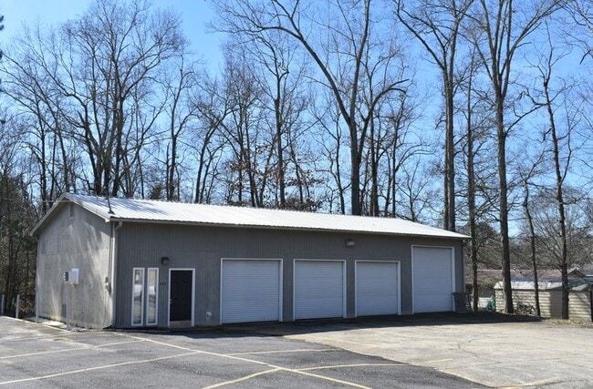
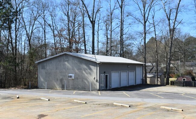
Property Record
495 Sutton Bridge Rd, Rainbow City, AL 35906

Property Detail
495 Sutton Bridge Rd
15-09-29-2-000-053.000
H/S BASE YEAR COM SW COR SW1/4 NW1/4 TH E 956.72 TH N 751.21 TO POB TH E 123.15 TH N 131 TH W 124.22 TH S 131 TO POB LYING IN
Warehouse
ETOWAH
B and X Area of moderate flood hazard, usually the area between the limits of the 100-year and 500-year floods.
Alabama
2025
0.38 AC
2025
Etowah County
010402
Birmingham
1,920 SF
Gadsden, AL
NEARBY LISTINGS FOR SALE OR LEASE
DEMOGRAPHICS near 495 Sutton Bridge Rd
1 mile
3 mile
5 mile
2025 Total Population
4,718
14,304
46,160
2030 Population
4,679
14,118
46,267
Pop Growth 2025-2030
(0.83%)
(1.30%)
+ 0.23%
Average Age
40
42
41
2025 Total Households
2,098
5,915
19,092
HH Growth 2025-2030
(0.86%)
(1.28%)
+ 0.29%
Median Household Inc
$59,792
$64,087
$50,414
Avg Household Size
2.20
2.30
2.30
2025 Avg HH Vehicles
2.00
2.00
2.00
Median Home Value
$212,342
$231,018
$175,576
Median Year Built
1981
1978
1969
Nearby Places
Map Layers
Map Styles
 Street
 Aerial
Layers
 Traffic
 Biking
Places
Listings with unknown addresses are not visible on the map
- Restaurants
- Banks
- Shops
- Fitness
- Groceries
SALE & LEASE HISTORY
LISTING DATE
SALE/LEASE

Mar 12, 2020
For Sale
Nearby Properties
Address
Land Use
TOTAL SIZE
Lot Size
Zoning
Address
Land Use
TOTAL SIZE
Lot Size
Zoning
94,357 SF
40 AC
Address
Land Use
TOTAL SIZE
Lot Size
Zoning
186,337 SF
68 AC
Address
Land Use
TOTAL SIZE
Lot Size
Zoning
178,460 SF
5.70 AC
Address
Land Use
TOTAL SIZE
Lot Size
Zoning
117,758 SF
1.07 AC
Address
Land Use
TOTAL SIZE
Lot Size
Zoning
114,798 SF
2.32 AC
Address
Land Use
TOTAL SIZE
Lot Size
Zoning
262,140 SF
30 AC
Address
Land Use
TOTAL SIZE
Lot Size
Zoning
40,805 SF
30.10 AC
Address
Land Use
TOTAL SIZE
Lot Size
Zoning
281,198 SF
13.10 AC
Address
Land Use
TOTAL SIZE
Lot Size
Zoning
49,964 SF
10.36 AC
Address
Land Use
TOTAL SIZE
Lot Size
Zoning
24,891 SF
21.70 AC
Address
Land Use
TOTAL SIZE
Lot Size
Zoning
4,210 SF
634 AC
Address
Land Use
TOTAL SIZE
Lot Size
Zoning
8,288 SF
10 AC
Address
Land Use
TOTAL SIZE
Lot Size
Zoning
102,908 SF
15.90 AC
Address
Land Use
TOTAL SIZE
Lot Size
Zoning
71,320 SF
16 AC
Address
Land Use
TOTAL SIZE
Lot Size
Zoning
529,532 SF
13.94 AC
Address
Land Use
TOTAL SIZE
Lot Size
Zoning
73,168 SF
1.72 AC
Address
Land Use
TOTAL SIZE
Lot Size
Zoning
13,464 SF
11 AC
Address
Land Use
TOTAL SIZE
Lot Size
Zoning
43,550 SF
1.15 AC
Address
Land Use
TOTAL SIZE
Lot Size
Zoning
19,081 SF
0.60 AC
Address
Land Use
TOTAL SIZE
Lot Size
Zoning
38,983 SF
5.12 AC
Address
Land Use
TOTAL SIZE
Lot Size
Zoning
9,028 SF
8.30 AC
Address
Land Use
TOTAL SIZE
Lot Size
Zoning
8,672 SF
4.90 AC
Address
Land Use
TOTAL SIZE
Lot Size
Zoning
5,920 SF
8 AC
Address
Land Use
TOTAL SIZE
Lot Size
Zoning
28,564 SF
4 AC
Address
Land Use
TOTAL SIZE
Lot Size
Zoning
82,699 SF
4.26 AC
Address
Land Use
TOTAL SIZE
Lot Size
Zoning
77,218 SF
2.43 AC
Address
Land Use
TOTAL SIZE
Lot Size
Zoning
10,164 SF
10.03 AC
Address
Land Use
TOTAL SIZE
Lot Size
Zoning
26,956 SF
0.93 AC
Address
Land Use
TOTAL SIZE
Lot Size
Zoning
23,045 SF
50.30 AC
The World's #1 Commercial Real Estate Marketplace
Connect with us
© 2026 CoStar Group
The information above has been obtained from sources believed reliable. While we do not doubt its accuracy we have not verified it and make no guarantee, warranty or representation about it. It is your responsibility to independently confirm its accuracy and completeness. Any projections, opinions, assumptions, or estimates used are for example only and do not represent the current or future performance of the property. The value of this transaction to you depends on tax and other factors which should be evaluated by your tax, financial, and legal advisors. You and your advisors should conduct a careful, independent investigation of the property to determine to your satisfaction the suitability of the property for your needs.