Property Record
209 Cottage Grove Rd, Madison, WI 53716


Current Lease Availabilities
NEARBY LISTINGS FOR SALE OR LEASE
Property Detail
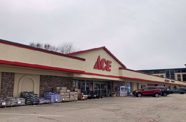
209 Cottage Grove Rd
Madison, WI
Blooming Grove Assessors Plat 7
0710-093-0312-5
ASSESSORS PLAT #7 BLOOMING GROVE, PRT OF LOT 30, DESC AS FOL: COMM NE COR SD LOT 30, TH W ALG S LN COTTAGE GROVE RD 240 FT TO POB, TH CONT ALG SD S LN 540 FT M/ L TO A PT 194 FT E FROM E LN MONONA DR TH S 00 DEG 51 MIN E 160.5 FT M/L, TH E 5 38.09 FT
Commercialnec
Dane
X
Wisconsin
55025C0429H
30
2024
1.90 AC
2024
Northeast Madison
002800
Milwaukee/Madison
13,691 SF
DEMOGRAPHICS near 209 Cottage Grove Rd
1 Mile
3 Mile
5 Mile
2024 Total Population
8,115
79,901
177,470
2029 Population
8,417
82,816
183,268
Pop Growth 2024-2029
+ 3.72%
+ 3.65%
+ 3.27%
Average Age
44
40
36
2024 Total Households
3,993
38,427
78,820
HH Growth 2024-2029
+ 3.86%
+ 3.73%
+ 3.51%
Median Household Inc
$68,684
$70,259
$61,820
Avg Household Size
2.00
2.00
2.00
2024 Avg HH Vehicles
2.00
2.00
1.00
Median Home Value
$247,594
$281,250
$285,151
Median Year Built
1956
1968
1974
Nearby Places
Map Layers
Map Styles
 Street
 Aerial
- Restaurants
- Banks
- Shops
- Fitness
- Groceries
PUBLIC TRANSPORTATION
AIRPORT
Dane County Regional/Truax Field
DRIVE
WALK
Distance
Dane County Regional/Truax Field
12 min
5.3 mi
Nearby Properties
Address
Land Use
TOTAL SIZE
Lot Size
Zoning
Address
Land Use
TOTAL SIZE
Lot Size
Zoning
461,454 SF
3.37 AC
CC-T
Address
Land Use
TOTAL SIZE
Lot Size
Zoning
251,632 SF
3.88 AC
TE
Address
Land Use
TOTAL SIZE
Lot Size
Zoning
289,884 SF
19.36 AC
SR-V2
Address
Land Use
TOTAL SIZE
Lot Size
Zoning
296,708 SF
1 AC
TE
Address
Land Use
TOTAL SIZE
Lot Size
Zoning
207,221 SF
0.60 AC
UMX
Address
Land Use
TOTAL SIZE
Lot Size
Zoning
269,675 SF
2.25 AC
TR-U2
Address
Land Use
TOTAL SIZE
Lot Size
Zoning
211,457 SF
329.05 AC
PD
Address
Land Use
TOTAL SIZE
Lot Size
Zoning
168,685 SF
14.05 AC
IL
Address
Land Use
TOTAL SIZE
Lot Size
Zoning
13,440 SF
10.98 AC
IL
Address
Land Use
TOTAL SIZE
Lot Size
Zoning
216,017 SF
3.35 AC
TE
Address
Land Use
TOTAL SIZE
Lot Size
Zoning
247,984 SF
1 AC
HIS-L
Address
Land Use
TOTAL SIZE
Lot Size
Zoning
372,177 SF
19.47 AC
SR-V2
Address
Land Use
TOTAL SIZE
Lot Size
Zoning
197,046 SF
TE
Address
Land Use
TOTAL SIZE
Lot Size
Zoning
169,491 SF
0.79 AC
HIS-L
Address
Land Use
TOTAL SIZE
Lot Size
Zoning
2.03 AC
Address
Land Use
TOTAL SIZE
Lot Size
Zoning
148,747 SF
0.83 AC
TE
Address
Land Use
TOTAL SIZE
Lot Size
Zoning
115,920 SF
2.38 AC
TE
Address
Land Use
TOTAL SIZE
Lot Size
Zoning
3.59 AC
Address
Land Use
TOTAL SIZE
Lot Size
Zoning
73,125 SF
1.49 AC
HIS-TL
Address
Land Use
TOTAL SIZE
Lot Size
Zoning
192,840 SF
0.37 AC
DC
Address
Land Use
TOTAL SIZE
Lot Size
Zoning
12,450 SF
9.40 AC
SE
Address
Land Use
TOTAL SIZE
Lot Size
Zoning
2.38 AC
Address
Land Use
TOTAL SIZE
Lot Size
Zoning
225,108 SF
2 AC
PD
Address
Land Use
TOTAL SIZE
Lot Size
Zoning
104,000 SF
11.21 AC
CC-T
Address
Land Use
TOTAL SIZE
Lot Size
Zoning
158,832 SF
0.58 AC
PD
Address
Land Use
TOTAL SIZE
Lot Size
Zoning
58,680 SF
6.29 AC
PD
Address
Land Use
TOTAL SIZE
Lot Size
Zoning
Address
Land Use
TOTAL SIZE
Lot Size
Zoning
149,897 SF
17.72 AC
IL
Address
Land Use
TOTAL SIZE
Lot Size
Zoning
92,130 SF
3.36 AC
PD
Address
Land Use
TOTAL SIZE
Lot Size
Zoning
3.49 AC
The World's #1 Commercial Real Estate Marketplace
Connect with us
© 2026 CoStar Group
The information above has been obtained from sources believed reliable. While we do not doubt its accuracy we have not verified it and make no guarantee, warranty or representation about it. It is your responsibility to independently confirm its accuracy and completeness. Any projections, opinions, assumptions, or estimates used are for example only and do not represent the current or future performance of the property. The value of this transaction to you depends on tax and other factors which should be evaluated by your tax, financial, and legal advisors. You and your advisors should conduct a careful, independent investigation of the property to determine to your satisfaction the suitability of the property for your needs.