Property Record
209 Crystal Dr, Riverhead, NY 11901
This Property Is For Sale
NEARBY LISTINGS FOR SALE OR LEASE
Property Detail
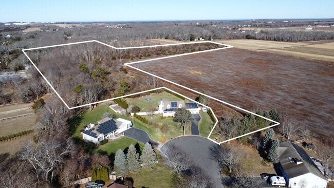
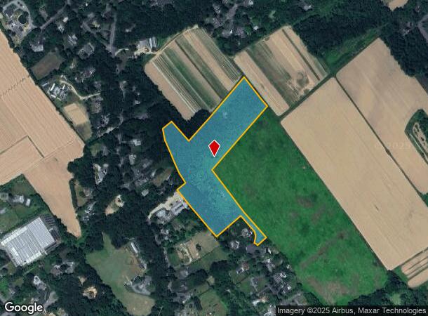
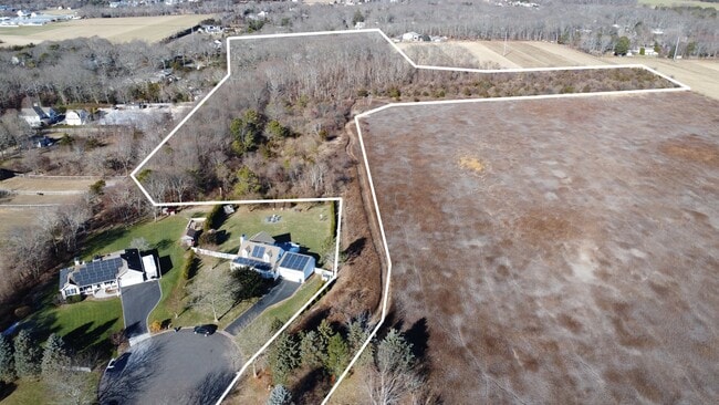
209 Crystal Dr
Nassau County-Suffolk County, NY
Map Crystal Pine Estates
0600-067-00-02-00-016-021
MAP X CRYSTAL PINE EST FILED 6/13/90 MAP 8958 OPEN SPACE PRESERVE
Recreationalacreage
Suffolk
X
New York
36103C0478H
16
2024
11.20 AC
2024
Eastern Suffolk
169906
Long Island (New York)
DEMOGRAPHICS near 209 Crystal Dr
1 Mile
3 Mile
5 Mile
2024 Total Population
1,078
12,625
34,391
2029 Population
1,024
12,333
34,286
Pop Growth 2024-2029
(5.01%)
(2.31%)
(0.31%)
Average Age
45
43
43
2024 Total Households
398
4,622
12,517
HH Growth 2024-2029
(5.78%)
(2.88%)
(0.67%)
Median Household Inc
$123,041
$87,596
$76,134
Avg Household Size
2.60
2.60
2.60
2024 Avg HH Vehicles
3.00
2.00
2.00
Median Home Value
$709,715
$518,982
$472,056
Median Year Built
1984
1983
1981
Nearby Places
Map Layers
Map Styles
 Street
 Aerial
- Restaurants
- Banks
- Shops
- Fitness
- Groceries
PUBLIC TRANSPORTATION
COMMUTER RAIL
Riverhead Station (Greenport Branch - Long Island Rail Road)
DRIVE
WALK
Distance
Riverhead Station (Greenport Branch - Long Island Rail Road)
9 min
4.0 mi
Mattituck Station (Greenport Branch - Long Island Rail Road)
DRIVE
WALK
Distance
Mattituck Station (Greenport Branch - Long Island Rail Road)
11 min
6.1 mi
AIRPORT
Long Island MacArthur
DRIVE
WALK
Distance
Long Island MacArthur
51 min
32.6 mi
Freight Ports
Port of New Haven
DRIVE
WALK
Distance
Port of New Haven
152 min
62.5 mi
Nearby Properties
Address
Land Use
TOTAL SIZE
Lot Size
Zoning
Address
Land Use
TOTAL SIZE
Lot Size
Zoning
51.70 AC
R15
Address
Land Use
TOTAL SIZE
Lot Size
Zoning
222 AC
H2O
Address
Land Use
TOTAL SIZE
Lot Size
Zoning
81.70 AC
R60
Address
Land Use
TOTAL SIZE
Lot Size
Zoning
16,699 SF
24.81 AC
03
Address
Land Use
TOTAL SIZE
Lot Size
Zoning
108,504 SF
31.20 AC
SC
Address
Land Use
TOTAL SIZE
Lot Size
Zoning
214.30 AC
10
Address
Land Use
TOTAL SIZE
Lot Size
Zoning
113,634 SF
27.49 AC
04
Address
Land Use
TOTAL SIZE
Lot Size
Zoning
73,651 SF
8.50 AC
3
Address
Land Use
TOTAL SIZE
Lot Size
Zoning
14,520 SF
21.20 AC
04
Address
Land Use
TOTAL SIZE
Lot Size
Zoning
274.40 AC
05
Address
Land Use
TOTAL SIZE
Lot Size
Zoning
4.20 AC
R10
Address
Land Use
TOTAL SIZE
Lot Size
Zoning
139,515 SF
12.30 AC
03
Address
Land Use
TOTAL SIZE
Lot Size
Zoning
6.03 AC
SC
Address
Land Use
TOTAL SIZE
Lot Size
Zoning
29.93 AC
RA80
Address
Land Use
TOTAL SIZE
Lot Size
Zoning
67,350 SF
6.80 AC
03
Address
Land Use
TOTAL SIZE
Lot Size
Zoning
21.30 AC
H2O
Address
Land Use
TOTAL SIZE
Lot Size
Zoning
3,906 SF
1.28 AC
4
Address
Land Use
TOTAL SIZE
Lot Size
Zoning
149.95 AC
APZ
Address
Land Use
TOTAL SIZE
Lot Size
Zoning
64,600 SF
3.40 AC
3
Address
Land Use
TOTAL SIZE
Lot Size
Zoning
11,000 SF
182 AC
01
Address
Land Use
TOTAL SIZE
Lot Size
Zoning
1,688 SF
34.47 AC
09
Address
Land Use
TOTAL SIZE
Lot Size
Zoning
15,476 SF
3.70 AC
DC3
Address
Land Use
TOTAL SIZE
Lot Size
Zoning
66,307 SF
11.09 AC
03
Address
Land Use
TOTAL SIZE
Lot Size
Zoning
3.80 AC
CRC
Address
Land Use
TOTAL SIZE
Lot Size
Zoning
6,352 SF
2.45 AC
R15
Address
Land Use
TOTAL SIZE
Lot Size
Zoning
5.47 AC
04
Address
Land Use
TOTAL SIZE
Lot Size
Zoning
5,596 SF
0.82 AC
R15
Address
Land Use
TOTAL SIZE
Lot Size
Zoning
5.01 AC
10
Address
Land Use
TOTAL SIZE
Lot Size
Zoning
227.20 AC
04
Address
Land Use
TOTAL SIZE
Lot Size
Zoning
20.60 AC
APZ
The World's #1 Commercial Real Estate Marketplace
Connect with us
© 2026 CoStar Group
The information above has been obtained from sources believed reliable. While we do not doubt its accuracy we have not verified it and make no guarantee, warranty or representation about it. It is your responsibility to independently confirm its accuracy and completeness. Any projections, opinions, assumptions, or estimates used are for example only and do not represent the current or future performance of the property. The value of this transaction to you depends on tax and other factors which should be evaluated by your tax, financial, and legal advisors. You and your advisors should conduct a careful, independent investigation of the property to determine to your satisfaction the suitability of the property for your needs.