Property Record
209 E 4Th St, Panama City, FL 32401
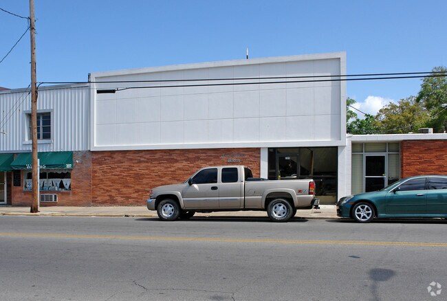
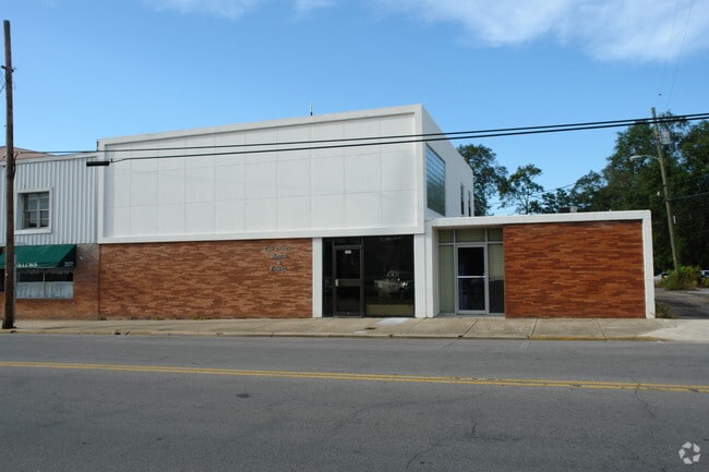
Property Detail
209 E 4Th St
19885-000-000
29/30/31/32 1S 12W -1.8- 177 **AND** 5/6 2S 12W MAP 178 BEG NE COR SEC 32 TH W 1332.59 N 647.02 NWLY 4187.88 W 1317.04 SLY 5253.97 SWLY 1680.78 SELY 5805.17 ELY 296.24 SELY 36.89 ELY 1730.10 TO E LI SEC 5 2S 12W N 2303.92 TO NE COR SAID SEC N ALG E L
Officebuilding
Bay
PC10
Florida
B and X Area of moderate flood hazard, usually the area between the limits of the 100-year and 500-year floods.
0.04 AC
2024
Downtown Panama City
2025
Other Market Areas
000302
Panama City-Panama City Beach, FL
3,200 SF
NEARBY LISTINGS FOR SALE OR LEASE
DEMOGRAPHICS near 209 E 4Th St
1 mile
3 mile
5 mile
2024 Total Population
4,408
27,988
74,697
2029 Population
4,949
30,904
83,025
Pop Growth 2024-2029
+ 12.27%
+ 10.42%
+ 11.15%
Average Age
43
40
39
2024 Total Households
1,898
11,300
29,313
HH Growth 2024-2029
+ 12.64%
+ 10.77%
+ 11.29%
Median Household Inc
$49,090
$50,976
$65,022
Avg Household Size
2.20
2.40
2.40
2024 Avg HH Vehicles
1.00
1.00
2.00
Median Home Value
$264,905
$244,368
$273,134
Median Year Built
1971
1973
1985
Nearby Places
Map Layers
Map Styles
 Street
 Aerial
Transit
 Traffic
 Biking
Places
Listings with unknown addresses are not visible on the map
- Restaurants
- Banks
- Shops
- Fitness
- Groceries
PUBLIC TRANSPORTATION
AIRPORT
Northwest Florida Beaches International
Drive
Walk
Distance
Northwest Florida Beaches International
39 min
23.1 mi
Freight Ports
Port of Panama City
Drive
Walk
Distance
Port of Panama City
13 min
5.8 mi
Nearby Properties
Address
Land Use
TOTAL SIZE
Lot Size
Zoning
Address
Land Use
TOTAL SIZE
Lot Size
Zoning
764,032 SF
12.80 AC
PC14
Address
Land Use
TOTAL SIZE
Lot Size
Zoning
477,423 SF
21.91 AC
PC09
Address
Land Use
TOTAL SIZE
Lot Size
Zoning
263,872 SF
41.33 AC
PC12
Address
Land Use
TOTAL SIZE
Lot Size
Zoning
154,028 SF
2.01 AC
PC10
Address
Land Use
TOTAL SIZE
Lot Size
Zoning
214,953 SF
14.58 AC
PC09
Address
Land Use
TOTAL SIZE
Lot Size
Zoning
86,629 SF
4.70 AC
Address
Land Use
TOTAL SIZE
Lot Size
Zoning
415,651 SF
266 AC
BC13
Address
Land Use
TOTAL SIZE
Lot Size
Zoning
33,305 SF
15 AC
PC09
Address
Land Use
TOTAL SIZE
Lot Size
Zoning
140,899 SF
15.48 AC
PC09
Address
Land Use
TOTAL SIZE
Lot Size
Zoning
194,474 SF
16.03 AC
PC09
Address
Land Use
TOTAL SIZE
Lot Size
Zoning
115,056 SF
21 AC
PC09
Address
Land Use
TOTAL SIZE
Lot Size
Zoning
55,300 SF
10.91 AC
PC12
Address
Land Use
TOTAL SIZE
Lot Size
Zoning
142,051 SF
13.43 AC
PC09
Address
Land Use
TOTAL SIZE
Lot Size
Zoning
28,314 SF
6.34 AC
PC05
Address
Land Use
TOTAL SIZE
Lot Size
Zoning
122,813 SF
9.58 AC
PC09
Address
Land Use
TOTAL SIZE
Lot Size
Zoning
68,418 SF
417.69 AC
PC11
Address
Land Use
TOTAL SIZE
Lot Size
Zoning
424,813 SF
30 AC
Address
Land Use
TOTAL SIZE
Lot Size
Zoning
164,923 SF
23.60 AC
PC09
Address
Land Use
TOTAL SIZE
Lot Size
Zoning
42,718 SF
7.77 AC
PC09
Address
Land Use
TOTAL SIZE
Lot Size
Zoning
207,286 SF
3.48 AC
PC10
Address
Land Use
TOTAL SIZE
Lot Size
Zoning
Address
Land Use
TOTAL SIZE
Lot Size
Zoning
Address
Land Use
TOTAL SIZE
Lot Size
Zoning
41,300 SF
17.87 AC
PC14
Address
Land Use
TOTAL SIZE
Lot Size
Zoning
98,827 SF
11.95 AC
PC09
Address
Land Use
TOTAL SIZE
Lot Size
Zoning
118,302 SF
8 AC
PC05
Address
Land Use
TOTAL SIZE
Lot Size
Zoning
256,570 SF
7 AC
PC14
Address
Land Use
TOTAL SIZE
Lot Size
Zoning
26,116 SF
3.38 AC
PC09
Address
Land Use
TOTAL SIZE
Lot Size
Zoning
126,234 SF
20.02 AC
PI
Address
Land Use
TOTAL SIZE
Lot Size
Zoning
62,640 SF
0.48 AC
PC10
Address
Land Use
TOTAL SIZE
Lot Size
Zoning
101,092 SF
9.11 AC
PC09
The World's #1 Commercial Real Estate Marketplace
Connect with us
© 2026 CoStar Group
The information above has been obtained from sources believed reliable. While we do not doubt its accuracy we have not verified it and make no guarantee, warranty or representation about it. It is your responsibility to independently confirm its accuracy and completeness. Any projections, opinions, assumptions, or estimates used are for example only and do not represent the current or future performance of the property. The value of this transaction to you depends on tax and other factors which should be evaluated by your tax, financial, and legal advisors. You and your advisors should conduct a careful, independent investigation of the property to determine to your satisfaction the suitability of the property for your needs.