Property Record
209 Nashua Rd, Londonderry, NH 03053
NEARBY LISTINGS FOR SALE OR LEASE
-
-
View all Londonderry listings for sale on LoopNet.com
Property Detail
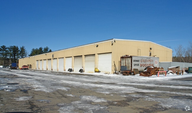
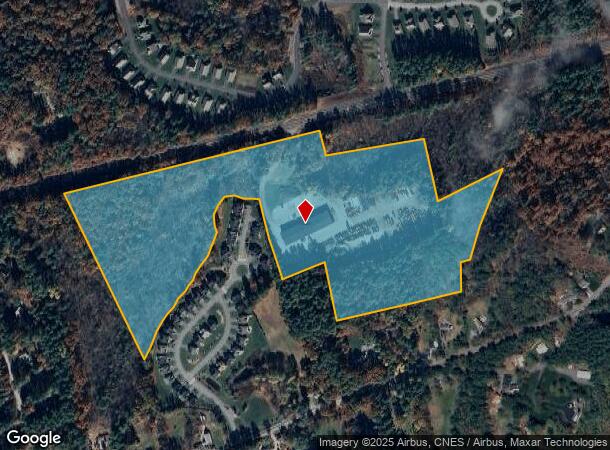
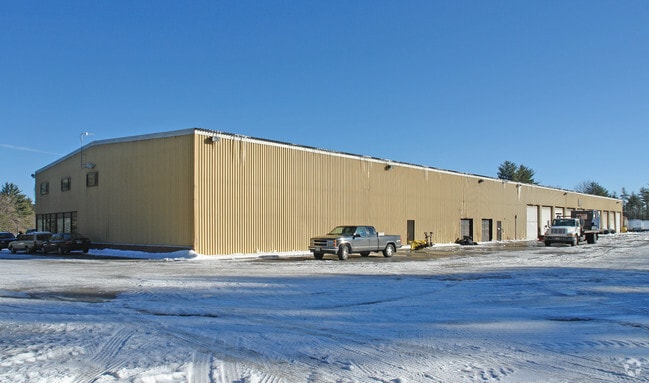
209 Nashua Rd
LOND-000003-000000-000132B
Rockingham
Truckterminal
New Hampshire
X
132b-0
33011C0509D
33 AC
2024
Rockingham
2024
Boston
003902
Boston-Cambridge-Newton, MA-NH
35,200 SF
DEMOGRAPHICS near 209 Nashua Rd
1 Mile
3 Mile
5 Mile
2024 Total Population
2,744
20,670
65,109
2029 Population
2,881
21,413
67,321
Pop Growth 2024-2029
+ 4.99%
+ 3.59%
+ 3.40%
Average Age
42
42
41
2024 Total Households
934
7,507
24,347
HH Growth 2024-2029
+ 4.93%
+ 3.54%
+ 3.35%
Median Household Inc
$146,176
$126,358
$115,193
Avg Household Size
2.90
2.70
2.60
2024 Avg HH Vehicles
2.00
2.00
2.00
Median Home Value
$445,470
$411,016
$397,744
Median Year Built
1983
1983
1983
Nearby Places
Map Layers
Map Styles
 Street
 Aerial
- Restaurants
- Banks
- Shops
- Fitness
- Groceries
PUBLIC TRANSPORTATION
AIRPORT
Manchester Boston Regional
DRIVE
WALK
Distance
Manchester Boston Regional
24 min
10.5 mi
General Edward Lawrence Logan International
DRIVE
WALK
Distance
General Edward Lawrence Logan International
61 min
46.0 mi
Freight Ports
Port of Boston
DRIVE
WALK
Distance
Port of Boston
62 min
45.7 mi
Nearby Properties
Address
Land Use
TOTAL SIZE
Lot Size
Zoning
Address
Land Use
TOTAL SIZE
Lot Size
Zoning
214,583 SF
110.37 AC
AR-I
Address
Land Use
TOTAL SIZE
Lot Size
Zoning
186,072 SF
18.64 AC
C-I
Address
Land Use
TOTAL SIZE
Lot Size
Zoning
133,188 SF
1.53 AC
AR-I
Address
Land Use
TOTAL SIZE
Lot Size
Zoning
12.73 AC
C-I
Address
Land Use
TOTAL SIZE
Lot Size
Zoning
30.26 AC
C-I
Address
Land Use
TOTAL SIZE
Lot Size
Zoning
31.14 AC
AR-I
Address
Land Use
TOTAL SIZE
Lot Size
Zoning
195,610 SF
20.49 AC
C-I
Address
Land Use
TOTAL SIZE
Lot Size
Zoning
22.09 AC
AR-I
Address
Land Use
TOTAL SIZE
Lot Size
Zoning
90,406 SF
24.78 AC
AR-I
Address
Land Use
TOTAL SIZE
Lot Size
Zoning
80,710 SF
20 AC
AR-I
Address
Land Use
TOTAL SIZE
Lot Size
Zoning
41,989 SF
C-III
Address
Land Use
TOTAL SIZE
Lot Size
Zoning
42,956 SF
2.31 AC
Address
Land Use
TOTAL SIZE
Lot Size
Zoning
60,572 SF
5.65 AC
C-I
Address
Land Use
TOTAL SIZE
Lot Size
Zoning
11.28 AC
C-I
Address
Land Use
TOTAL SIZE
Lot Size
Zoning
34,442 SF
99.29 AC
AR-I
Address
Land Use
TOTAL SIZE
Lot Size
Zoning
59,544 SF
20.23 AC
C-II
Address
Land Use
TOTAL SIZE
Lot Size
Zoning
15,000 SF
C-III
Address
Land Use
TOTAL SIZE
Lot Size
Zoning
3,720 SF
14.65 AC
C-I
Address
Land Use
TOTAL SIZE
Lot Size
Zoning
45,330 SF
1 AC
R3
Address
Land Use
TOTAL SIZE
Lot Size
Zoning
9.67 AC
C-I
Address
Land Use
TOTAL SIZE
Lot Size
Zoning
69,900 SF
18.10 AC
BD
Address
Land Use
TOTAL SIZE
Lot Size
Zoning
44,280 SF
1 AC
R3
Address
Land Use
TOTAL SIZE
Lot Size
Zoning
25,083 SF
1.42 AC
C-III
Address
Land Use
TOTAL SIZE
Lot Size
Zoning
2,400 SF
15.50 AC
G1
Address
Land Use
TOTAL SIZE
Lot Size
Zoning
31,091 SF
3.42 AC
BD
Address
Land Use
TOTAL SIZE
Lot Size
Zoning
20,986 SF
2.41 AC
C-III
Address
Land Use
TOTAL SIZE
Lot Size
Zoning
2,320 SF
13 AC
C-I
Address
Land Use
TOTAL SIZE
Lot Size
Zoning
41,225 SF
7.35 AC
C-I
Address
Land Use
TOTAL SIZE
Lot Size
Zoning
11.94 AC
I1/2
Address
Land Use
TOTAL SIZE
Lot Size
Zoning
60,654 SF
7.03 AC
IND1
The World's #1 Commercial Real Estate Marketplace
Connect with us
© 2025 CoStar Group
The information above has been obtained from sources believed reliable. While we do not doubt its accuracy we have not verified it and make no guarantee, warranty or representation about it. It is your responsibility to independently confirm its accuracy and completeness. Any projections, opinions, assumptions, or estimates used are for example only and do not represent the current or future performance of the property. The value of this transaction to you depends on tax and other factors which should be evaluated by your tax, financial, and legal advisors. You and your advisors should conduct a careful, independent investigation of the property to determine to your satisfaction the suitability of the property for your needs.