Property Record
209 Nw Highway 441, Micanopy, FL 32667

NEARBY LISTINGS FOR SALE OR LEASE
Property Detail
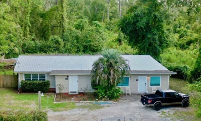
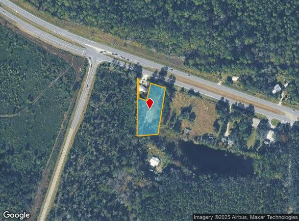
209 Nw Highway 441
16777-008-000
Capstone Quarters
Vacantlandnec
BEGIN AT INTERSECTION W LINE SEC & S R/W US 441 POB S 410 FT E 127 FT N/LY 350 FT M/L TO A PT ON S R/W US 441 A DISTANCE OF 210 FT E/LY OF POB N/LY ALONG R/W 100 FT S/LY 125 FT TO A PT 69 FT E OF W LINE SEC W 59 FT N 132 FT TO R/W W/LY 10 FT M/L TO P
A
Alachua
12001C0470D
Florida
2025
1.24 AC
2025
Gainesville
002102
Other Market Areas
1,024 SF
Gainesville, FL
DEMOGRAPHICS near 209 Nw Highway 441
1 Mile
3 Mile
5 Mile
2024 Total Population
582
1,645
2,828
2029 Population
612
1,741
3,028
Pop Growth 2024-2029
+ 5.15%
+ 5.84%
+ 7.07%
Average Age
49
48
48
2024 Total Households
279
760
1,273
HH Growth 2024-2029
+ 5.02%
+ 5.79%
+ 6.99%
Median Household Inc
$46,666
$60,542
$65,577
Avg Household Size
2.10
2.20
2.20
2024 Avg HH Vehicles
2.00
2.00
2.00
Median Home Value
$265,384
$281,439
$289,104
Median Year Built
1969
1972
1976
Nearby Places
Map Layers
Map Styles
 Street
 Aerial
- Restaurants
- Banks
- Shops
- Fitness
- Groceries
PUBLIC TRANSPORTATION
AIRPORT
Gainesville Regional
DRIVE
WALK
Distance
Gainesville Regional
27 min
15.8 mi
Freight Ports
Jacksonville Port
DRIVE
WALK
Distance
Jacksonville Port
112 min
85.6 mi
SALE & LEASE HISTORY
LISTING DATE
SALE/LEASE

Aug 23, 2022
For Sale
Nearby Properties
Address
Land Use
TOTAL SIZE
Lot Size
Zoning
Address
Land Use
TOTAL SIZE
Lot Size
Zoning
8,597 SF
918.57 AC
C-1
Address
Land Use
TOTAL SIZE
Lot Size
Zoning
24,552 SF
224.69 AC
A
Address
Land Use
TOTAL SIZE
Lot Size
Zoning
4,521 SF
17.71 AC
C-1
Address
Land Use
TOTAL SIZE
Lot Size
Zoning
19,651 SF
9 AC
BH
Address
Land Use
TOTAL SIZE
Lot Size
Zoning
18,860 SF
3.76 AC
C-1
Address
Land Use
TOTAL SIZE
Lot Size
Zoning
19,536 SF
3.55 AC
BH
Address
Land Use
TOTAL SIZE
Lot Size
Zoning
356.30 AC
P
Address
Land Use
TOTAL SIZE
Lot Size
Zoning
14,834 SF
2.61 AC
R-2
Address
Land Use
TOTAL SIZE
Lot Size
Zoning
5,444 SF
581.43 AC
C-1
Address
Land Use
TOTAL SIZE
Lot Size
Zoning
84.09 AC
A1
Address
Land Use
TOTAL SIZE
Lot Size
Zoning
5,581 SF
0.11 AC
C-1
Address
Land Use
TOTAL SIZE
Lot Size
Zoning
8,398 SF
2.06 AC
C1
Address
Land Use
TOTAL SIZE
Lot Size
Zoning
9,669 SF
3.81 AC
R2
Address
Land Use
TOTAL SIZE
Lot Size
Zoning
8,807 SF
2.04 AC
R2
Address
Land Use
TOTAL SIZE
Lot Size
Zoning
5,840 SF
0.32 AC
C1
Address
Land Use
TOTAL SIZE
Lot Size
Zoning
4,400 SF
1.44 AC
C-2
Address
Land Use
TOTAL SIZE
Lot Size
Zoning
117,007 SF
37.08 AC
I
Address
Land Use
TOTAL SIZE
Lot Size
Zoning
6,124 SF
0.12 AC
C-1
Address
Land Use
TOTAL SIZE
Lot Size
Zoning
9,000 SF
2.87 AC
R2
Address
Land Use
TOTAL SIZE
Lot Size
Zoning
4,052 SF
15.65 AC
R-1A
Address
Land Use
TOTAL SIZE
Lot Size
Zoning
4,778 SF
2.07 AC
BH
Address
Land Use
TOTAL SIZE
Lot Size
Zoning
4,223 SF
2.73 AC
C2
Address
Land Use
TOTAL SIZE
Lot Size
Zoning
4,432 SF
1.61 AC
BA
Address
Land Use
TOTAL SIZE
Lot Size
Zoning
3,947 SF
20.71 AC
A
Address
Land Use
TOTAL SIZE
Lot Size
Zoning
4,946 SF
71.95 AC
C-1
Address
Land Use
TOTAL SIZE
Lot Size
Zoning
3,456 SF
0.45 AC
C1
Address
Land Use
TOTAL SIZE
Lot Size
Zoning
6,692 SF
3.09 AC
R2
Address
Land Use
TOTAL SIZE
Lot Size
Zoning
5,750 SF
2.20 AC
A
Address
Land Use
TOTAL SIZE
Lot Size
Zoning
5,093 SF
1.76 AC
C2
Address
Land Use
TOTAL SIZE
Lot Size
Zoning
4,234 SF
8.02 AC
A
The World's #1 Commercial Real Estate Marketplace
Connect with us
© 2025 CoStar Group
The information above has been obtained from sources believed reliable. While we do not doubt its accuracy we have not verified it and make no guarantee, warranty or representation about it. It is your responsibility to independently confirm its accuracy and completeness. Any projections, opinions, assumptions, or estimates used are for example only and do not represent the current or future performance of the property. The value of this transaction to you depends on tax and other factors which should be evaluated by your tax, financial, and legal advisors. You and your advisors should conduct a careful, independent investigation of the property to determine to your satisfaction the suitability of the property for your needs.