Property Record
209 Pershing Dr, Ansonia, CT 06401
Save to a Folder
{{folder.Name}}
{{folder.ListingIds.length}} Properties
{{folder.ListingIds.length}} Property
Create a New Folder
Property Detail
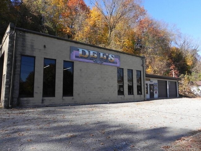
209 Pershing Dr
ANSO-000030-000009-000001
Naugatuck Vly
Parkingstructure
Connecticut
C
1
B and X Area of moderate flood hazard, usually the area between the limits of the 100-year and 500-year floods.
0.48 AC
2025
Ansonia
2025
Westchester/So Connecticut
125300
New Haven, CT
1,683 SF
NEARBY LISTINGS FOR SALE OR LEASE
DEMOGRAPHICS near 209 Pershing Dr
1 mile
3 mile
5 mile
2025 Total Population
13,515
54,391
98,273
2030 Population
13,719
55,717
100,685
Pop Growth 2025-2030
+ 1.51%
+ 2.44%
+ 2.45%
Average Age
40
42
43
2025 Total Households
5,577
22,427
39,504
HH Growth 2025-2030
+ 1.52%
+ 2.47%
+ 2.52%
Median Household Inc
$71,461
$87,883
$98,787
Avg Household Size
2.40
2.40
2.50
2025 Avg HH Vehicles
2.00
2.00
2.00
Median Home Value
$284,759
$336,960
$402,669
Median Year Built
1949
1962
1967
Nearby Places
Map Layers
Map Styles
 Street
 Aerial
Layers
 Traffic
 Biking
Places
Listings with unknown addresses are not visible on the map
- Restaurants
- Banks
- Shops
- Fitness
- Groceries
PUBLIC TRANSPORTATION
COMMUTER RAIL
Ansonia Station (New Haven Line - Metro-North Commuter Railroad Company (Metro-North))
Drive
Walk
Distance
Ansonia Station (New Haven Line - Metro-North Commuter Railroad Company (Metro-North))
1 min
9 min
0.5 mi
Derby-Shelton Station (New Haven Line - Metro-North Commuter Railroad Company (Metro-North))
Drive
Walk
Distance
Derby-Shelton Station (New Haven Line - Metro-North Commuter Railroad Company (Metro-North))
3 min
1.7 mi
AIRPORT
Tweed/New Haven
Drive
Walk
Distance
Tweed/New Haven
26 min
15.8 mi
Freight Ports
Port of New Haven
Drive
Walk
Distance
Port of New Haven
21 min
13.0 mi
SALE & LEASE HISTORY
LISTING DATE
SALE/LEASE

Nov 10, 2020
For Sale
Feb 23, 2024
For Lease
Nearby Properties
Address
Land Use
TOTAL SIZE
Lot Size
Zoning
Address
Land Use
TOTAL SIZE
Lot Size
Zoning
5.14 AC
H/C
Address
Land Use
TOTAL SIZE
Lot Size
Zoning
68,102 SF
4.44 AC
IB-2
Address
Land Use
TOTAL SIZE
Lot Size
Zoning
1,444 SF
50.40 AC
R-1
Address
Land Use
TOTAL SIZE
Lot Size
Zoning
4,320 SF
29.27 AC
R-1
Address
Land Use
TOTAL SIZE
Lot Size
Zoning
172,324 SF
46.29 AC
R-1
Address
Land Use
TOTAL SIZE
Lot Size
Zoning
166,388 SF
58 AC
A
Address
Land Use
TOTAL SIZE
Lot Size
Zoning
118,750 SF
36.27 AC
R-40
Address
Land Use
TOTAL SIZE
Lot Size
Zoning
122,278 SF
14 AC
A
Address
Land Use
TOTAL SIZE
Lot Size
Zoning
52.09 AC
P
Address
Land Use
TOTAL SIZE
Lot Size
Zoning
38,411 SF
4.49 AC
I-1
Address
Land Use
TOTAL SIZE
Lot Size
Zoning
11,028 SF
16.50 AC
Address
Land Use
TOTAL SIZE
Lot Size
Zoning
107,130 SF
0.53 AC
CB-2
Address
Land Use
TOTAL SIZE
Lot Size
Zoning
14.80 AC
C
Address
Land Use
TOTAL SIZE
Lot Size
Zoning
83,675 SF
4.65 AC
A
Address
Land Use
TOTAL SIZE
Lot Size
Zoning
110,545 SF
4.20 AC
B
Address
Land Use
TOTAL SIZE
Lot Size
Zoning
128,185 SF
9.20 AC
HI
Address
Land Use
TOTAL SIZE
Lot Size
Zoning
138,448 SF
10.05 AC
IB-1
Address
Land Use
TOTAL SIZE
Lot Size
Zoning
16.30 AC
B-1
Address
Land Use
TOTAL SIZE
Lot Size
Zoning
113,400 SF
12.78 AC
CDD
Address
Land Use
TOTAL SIZE
Lot Size
Zoning
20 AC
B-1
Address
Land Use
TOTAL SIZE
Lot Size
Zoning
61,298 SF
6.62 AC
C
Address
Land Use
TOTAL SIZE
Lot Size
Zoning
50,935 SF
0.70 AC
CB-2
Address
Land Use
TOTAL SIZE
Lot Size
Zoning
1,280 SF
7.20 AC
R-3
Address
Land Use
TOTAL SIZE
Lot Size
Zoning
2,860 SF
20 AC
R-1
Address
Land Use
TOTAL SIZE
Lot Size
Zoning
2,364 SF
B-1
Address
Land Use
TOTAL SIZE
Lot Size
Zoning
5.08 AC
LI-1
Address
Land Use
TOTAL SIZE
Lot Size
Zoning
46,826 SF
0.46 AC
IB-2
Address
Land Use
TOTAL SIZE
Lot Size
Zoning
82,278 SF
8 AC
A
Address
Land Use
TOTAL SIZE
Lot Size
Zoning
68,840 SF
1.04 AC
IB-2
Address
Land Use
TOTAL SIZE
Lot Size
Zoning
3,350 SF
3.10 AC
IB-2
The World's #1 Commercial Real Estate Marketplace
Connect with us
© 2026 CoStar Group
The information above has been obtained from sources believed reliable. While we do not doubt its accuracy we have not verified it and make no guarantee, warranty or representation about it. It is your responsibility to independently confirm its accuracy and completeness. Any projections, opinions, assumptions, or estimates used are for example only and do not represent the current or future performance of the property. The value of this transaction to you depends on tax and other factors which should be evaluated by your tax, financial, and legal advisors. You and your advisors should conduct a careful, independent investigation of the property to determine to your satisfaction the suitability of the property for your needs.