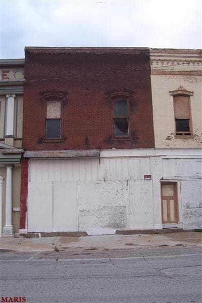
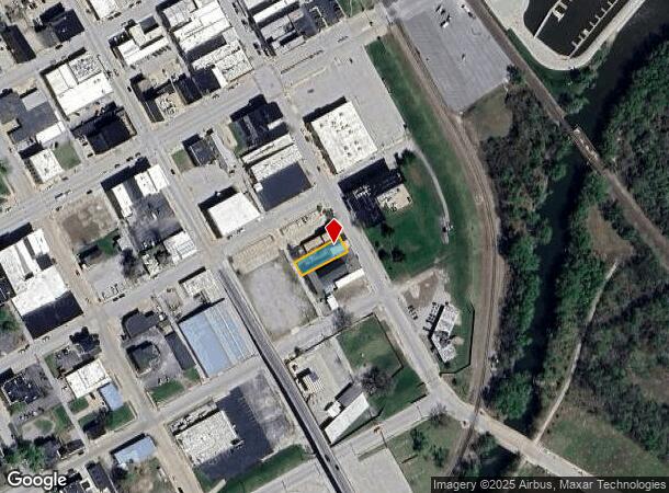
Property Record
209 S Main St, Hannibal, MO 63401
NEARBY LISTINGS FOR SALE OR LEASE
-
-
View all Hannibal listings for sale on LoopNet.com
Property Detail
209 S Main St
Hannibal, MO
O T
010.08.28.2.31.006.000
SUBD O.T., BLK 14, S23 LOT 3 DIM DEED-43.7 X 142
Commercialnec
Marion
X
Missouri
17149C0200D
3
2024
0.10 AC
2024
Other Market Areas
960800
DEMOGRAPHICS near 209 S Main St
1 mile
3 mile
5 mile
2024 Total Population
4,907
16,777
20,930
2029 Population
4,979
16,829
20,910
Pop Growth 2024-2029
+ 1.47%
+ 0.31%
(0.10%)
Average Age
38
40
40
2024 Total Households
1,987
6,764
8,439
HH Growth 2024-2029
+ 1.51%
+ 0.31%
(0.13%)
Median Household Inc
$38,844
$48,508
$53,563
Avg Household Size
2.30
2.30
2.30
2024 Avg HH Vehicles
2.00
2.00
2.00
Median Home Value
$100,485
$127,616
$141,219
Median Year Built
1948
1963
1970
Nearby Places
Map Layers
Map Styles
 Street
 Aerial
Transit
 Traffic
 Biking
Places
Listings with unknown addresses are not visible on the map
- Restaurants
- Banks
- Shops
- Fitness
- Groceries
Nearby Properties
Address
Land Use
TOTAL SIZE
Lot Size
Zoning
Address
Land Use
TOTAL SIZE
Lot Size
Zoning
Address
Land Use
TOTAL SIZE
Lot Size
Zoning
186,518 SF
20.60 AC
Address
Land Use
TOTAL SIZE
Lot Size
Zoning
81,217 SF
7.40 AC
Address
Land Use
TOTAL SIZE
Lot Size
Zoning
103,290 SF
19.80 AC
Address
Land Use
TOTAL SIZE
Lot Size
Zoning
1.60 AC
Address
Land Use
TOTAL SIZE
Lot Size
Zoning
1.13 AC
SR
Address
Land Use
TOTAL SIZE
Lot Size
Zoning
155,960 SF
16.40 AC
Address
Land Use
TOTAL SIZE
Lot Size
Zoning
3.30 AC
Address
Land Use
TOTAL SIZE
Lot Size
Zoning
40,894 SF
11.50 AC
Address
Land Use
TOTAL SIZE
Lot Size
Zoning
1.80 AC
Address
Land Use
TOTAL SIZE
Lot Size
Zoning
1,999 SF
9.90 AC
Address
Land Use
TOTAL SIZE
Lot Size
Zoning
Address
Land Use
TOTAL SIZE
Lot Size
Zoning
4.80 AC
Address
Land Use
TOTAL SIZE
Lot Size
Zoning
7.80 AC
Address
Land Use
TOTAL SIZE
Lot Size
Zoning
47,700 SF
0.90 AC
Address
Land Use
TOTAL SIZE
Lot Size
Zoning
13,751 SF
1.60 AC
Address
Land Use
TOTAL SIZE
Lot Size
Zoning
Address
Land Use
TOTAL SIZE
Lot Size
Zoning
7.07 AC
Address
Land Use
TOTAL SIZE
Lot Size
Zoning
5.20 AC
Address
Land Use
TOTAL SIZE
Lot Size
Zoning
20,260 SF
9.10 AC
Address
Land Use
TOTAL SIZE
Lot Size
Zoning
2,183 SF
2.90 AC
Address
Land Use
TOTAL SIZE
Lot Size
Zoning
1.34 AC
Address
Land Use
TOTAL SIZE
Lot Size
Zoning
Address
Land Use
TOTAL SIZE
Lot Size
Zoning
13,231 SF
1.80 AC
Address
Land Use
TOTAL SIZE
Lot Size
Zoning
8,384 SF
6.80 AC
Address
Land Use
TOTAL SIZE
Lot Size
Zoning
4.70 AC
Address
Land Use
TOTAL SIZE
Lot Size
Zoning
Address
Land Use
TOTAL SIZE
Lot Size
Zoning
4,800 SF
12.71 AC
Address
Land Use
TOTAL SIZE
Lot Size
Zoning
Address
Land Use
TOTAL SIZE
Lot Size
Zoning
3.10 AC
The World's #1 Commercial Real Estate Marketplace
Connect with us
© 2026 CoStar Group
The information above has been obtained from sources believed reliable. While we do not doubt its accuracy we have not verified it and make no guarantee, warranty or representation about it. It is your responsibility to independently confirm its accuracy and completeness. Any projections, opinions, assumptions, or estimates used are for example only and do not represent the current or future performance of the property. The value of this transaction to you depends on tax and other factors which should be evaluated by your tax, financial, and legal advisors. You and your advisors should conduct a careful, independent investigation of the property to determine to your satisfaction the suitability of the property for your needs.