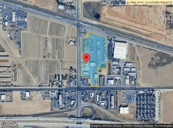
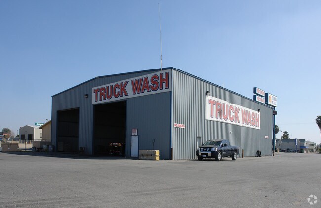
Property Record
209 Weedpatch 129 -209 Hw Hwy, Bakersfield, CA 93307

NEARBY LISTINGS FOR SALE OR LEASE
-
-
View all Bakersfield listings for sale on LoopNet.com
Property Detail
209 Weedpatch 129 -209 Hw Hwy
Bakersfield, CA
First Edison
388-450-02-00-4
CITY FSTED , BLOCK , LOT P 58
Commercialnec
Kern
A
California
06029C2306E
p
2024
12.37 AC
2025
SE Outlying Kern County
002403
Bakersfield
9,627 SF
DEMOGRAPHICS near 209 Weedpatch 129 -209 Hw Hwy
1 Mile
3 Mile
5 Mile
2024 Total Population
5,452
55,465
140,296
2029 Population
5,405
55,477
140,200
Pop Growth 2024-2029
(0.86%)
+ 0.02%
(0.07%)
Average Age
33
33
33
2024 Total Households
1,443
15,126
40,489
HH Growth 2024-2029
(1.04%)
(0.03%)
(0.10%)
Median Household Inc
$47,666
$49,834
$46,370
Avg Household Size
3.70
3.60
3.30
2024 Avg HH Vehicles
2.00
2.00
2.00
Median Home Value
$224,750
$239,400
$246,642
Median Year Built
1988
1978
1973
Nearby Places
Map Layers
Map Styles
 Street
 Aerial
- Restaurants
- Banks
- Shops
- Fitness
- Groceries
PUBLIC TRANSPORTATION
COMMUTER RAIL
DRIVE
WALK
Distance
12 min
6.2 mi
AIRPORT
Meadows Field
DRIVE
WALK
Distance
Meadows Field
24 min
14.2 mi
Nearby Properties
Address
Land Use
TOTAL SIZE
Lot Size
Zoning
Address
Land Use
TOTAL SIZE
Lot Size
Zoning
18,000 SF
35.01 AC
M-2
Address
Land Use
TOTAL SIZE
Lot Size
Zoning
1.38 AC
C-2
Address
Land Use
TOTAL SIZE
Lot Size
Zoning
66,139 SF
4.48 AC
CO
Address
Land Use
TOTAL SIZE
Lot Size
Zoning
112,052 SF
3.14 AC
R3
Address
Land Use
TOTAL SIZE
Lot Size
Zoning
66,139 SF
4.48 AC
CO
Address
Land Use
TOTAL SIZE
Lot Size
Zoning
103,536 SF
6.31 AC
R-3
Address
Land Use
TOTAL SIZE
Lot Size
Zoning
50,445 SF
2.53 AC
C2
Address
Land Use
TOTAL SIZE
Lot Size
Zoning
10.31 AC
Address
Land Use
TOTAL SIZE
Lot Size
Zoning
127,224 SF
7 AC
R-2/PUD
Address
Land Use
TOTAL SIZE
Lot Size
Zoning
17,567 SF
19.39 AC
M2
Address
Land Use
TOTAL SIZE
Lot Size
Zoning
17.85 AC
M3
Address
Land Use
TOTAL SIZE
Lot Size
Zoning
0.41 AC
R1
Address
Land Use
TOTAL SIZE
Lot Size
Zoning
33,264 SF
28.68 AC
AG
Address
Land Use
TOTAL SIZE
Lot Size
Zoning
66,582 SF
3.36 AC
R-2
Address
Land Use
TOTAL SIZE
Lot Size
Zoning
68,264 SF
6.56 AC
C2
Address
Land Use
TOTAL SIZE
Lot Size
Zoning
46,522 SF
3.35 AC
R2
Address
Land Use
TOTAL SIZE
Lot Size
Zoning
34,733 SF
7.25 AC
C2
Address
Land Use
TOTAL SIZE
Lot Size
Zoning
11.05 AC
C2/PCD
Address
Land Use
TOTAL SIZE
Lot Size
Zoning
95,258 SF
5.34 AC
PUD
Address
Land Use
TOTAL SIZE
Lot Size
Zoning
93,070 SF
7.98 AC
PUD
Address
Land Use
TOTAL SIZE
Lot Size
Zoning
97,900 SF
6.98 AC
M-2 PD
Address
Land Use
TOTAL SIZE
Lot Size
Zoning
44,779 SF
2.17 AC
M2
Address
Land Use
TOTAL SIZE
Lot Size
Zoning
41,089 SF
5.96 AC
C-2 PD
Address
Land Use
TOTAL SIZE
Lot Size
Zoning
39,175 SF
12.21 AC
M2
Address
Land Use
TOTAL SIZE
Lot Size
Zoning
47,592 SF
35.87 AC
M2
Address
Land Use
TOTAL SIZE
Lot Size
Zoning
5.63 AC
C2
Address
Land Use
TOTAL SIZE
Lot Size
Zoning
2.63 AC
M-2
Address
Land Use
TOTAL SIZE
Lot Size
Zoning
85,718 SF
4.72 AC
R-3
Address
Land Use
TOTAL SIZE
Lot Size
Zoning
5,809 SF
3.86 AC
R-3
The World's #1 Commercial Real Estate Marketplace
Connect with us
© 2025 CoStar Group
The information above has been obtained from sources believed reliable. While we do not doubt its accuracy we have not verified it and make no guarantee, warranty or representation about it. It is your responsibility to independently confirm its accuracy and completeness. Any projections, opinions, assumptions, or estimates used are for example only and do not represent the current or future performance of the property. The value of this transaction to you depends on tax and other factors which should be evaluated by your tax, financial, and legal advisors. You and your advisors should conduct a careful, independent investigation of the property to determine to your satisfaction the suitability of the property for your needs.