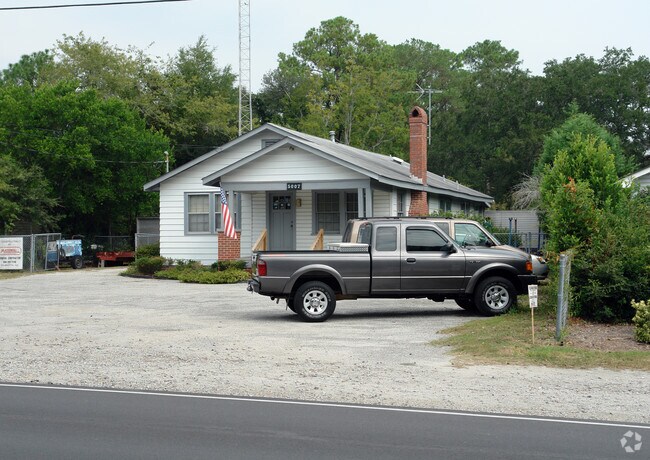
Property Record
5007 Wrightsville Ave, Wilmington, NC 28403


NEARBY LISTINGS FOR SALE OR LEASE
Property Detail
5007 Wrightsville Ave
Wilmington, NC
5580 Winter Park Extention, Dist 5
R05520-004-014-000
HARRISS NO 1
Commercialnec
New Hanover
X
North Carolina
3720314700K
14
2025
0.35 AC
2025
Midtown
011906
Wilmington
1,323 SF
DEMOGRAPHICS near 5007 Wrightsville Ave
1 Mile
3 Mile
5 Mile
2024 Total Population
5,387
65,648
149,577
2029 Population
5,834
70,936
163,075
Pop Growth 2024-2029
+ 8.30%
+ 8.06%
+ 9.02%
Average Age
37
38
40
2024 Total Households
2,517
28,407
67,115
HH Growth 2024-2029
+ 8.62%
+ 8.74%
+ 9.67%
Median Household Inc
$46,454
$57,537
$59,758
Avg Household Size
2.00
2.10
2.10
2024 Avg HH Vehicles
2.00
2.00
2.00
Median Home Value
$250,109
$317,338
$299,362
Median Year Built
1981
1988
1989
Nearby Places
Map Layers
Map Styles
 Street
 Aerial
- Restaurants
- Banks
- Shops
- Fitness
- Groceries
PUBLIC TRANSPORTATION
AIRPORT
Wilmington International
DRIVE
WALK
Distance
Wilmington International
21 min
10.0 mi
Freight Ports
Port of Wilmington
DRIVE
WALK
Distance
Port of Wilmington
12 min
6.1 mi
Nearby Properties
Address
Land Use
TOTAL SIZE
Lot Size
Zoning
Address
Land Use
TOTAL SIZE
Lot Size
Zoning
18,848 SF
649.08 AC
O&I,OFFICE
Address
Land Use
TOTAL SIZE
Lot Size
Zoning
393,150 SF
60.45 AC
O&I,OFFICE
Address
Land Use
TOTAL SIZE
Lot Size
Zoning
13,398 SF
15.67 AC
O&I,OFFICE
Address
Land Use
TOTAL SIZE
Lot Size
Zoning
35,600 SF
14.86 AC
CB,COMMUNI
Address
Land Use
TOTAL SIZE
Lot Size
Zoning
12,336 SF
67.48 AC
IND
Address
Land Use
TOTAL SIZE
Lot Size
Zoning
194,040 SF
7.74 AC
MX
Address
Land Use
TOTAL SIZE
Lot Size
Zoning
35,334 SF
38.86 AC
O&I,OFFICE
Address
Land Use
TOTAL SIZE
Lot Size
Zoning
5,563 SF
13.60 AC
MD-17
Address
Land Use
TOTAL SIZE
Lot Size
Zoning
606,792 SF
44.13 AC
RB,REGIONA
Address
Land Use
TOTAL SIZE
Lot Size
Zoning
191,720 SF
7.82 AC
RB,REGIONA
Address
Land Use
TOTAL SIZE
Lot Size
Zoning
Address
Land Use
TOTAL SIZE
Lot Size
Zoning
308,208 SF
7.80 AC
O&I,OFFICE
Address
Land Use
TOTAL SIZE
Lot Size
Zoning
142,207 SF
9.29 AC
O&I,OFFICE
Address
Land Use
TOTAL SIZE
Lot Size
Zoning
160,284 SF
59.79 AC
O&I,OFFICE
Address
Land Use
TOTAL SIZE
Lot Size
Zoning
150,588 SF
30.57 AC
RB,REGIONA
Address
Land Use
TOTAL SIZE
Lot Size
Zoning
128,015 SF
6.91 AC
RB,REGIONA
Address
Land Use
TOTAL SIZE
Lot Size
Zoning
153,764 SF
22.87 AC
RB,REGIONA
Address
Land Use
TOTAL SIZE
Lot Size
Zoning
108.30 AC
R-15,RESID
Address
Land Use
TOTAL SIZE
Lot Size
Zoning
6,780 SF
24.11 AC
RB,REGIONA
Address
Land Use
TOTAL SIZE
Lot Size
Zoning
228,521 SF
25.17 AC
RB,REGIONA
Address
Land Use
TOTAL SIZE
Lot Size
Zoning
116,691 SF
14.43 AC
RB,REGIONA
Address
Land Use
TOTAL SIZE
Lot Size
Zoning
24,966 SF
5.55 AC
O&I,OFFICE
Address
Land Use
TOTAL SIZE
Lot Size
Zoning
101,003 SF
7.89 AC
MX
Address
Land Use
TOTAL SIZE
Lot Size
Zoning
115,283 SF
4.45 AC
RB,REGIONA
Address
Land Use
TOTAL SIZE
Lot Size
Zoning
1,656 SF
74.28 AC
R-15,RESID
Address
Land Use
TOTAL SIZE
Lot Size
Zoning
4,428 SF
4.47 AC
O&I,OFFICE
Address
Land Use
TOTAL SIZE
Lot Size
Zoning
162,023 SF
17.56 AC
RB,REGIONA
Address
Land Use
TOTAL SIZE
Lot Size
Zoning
73,457 SF
6.77 AC
MX
Address
Land Use
TOTAL SIZE
Lot Size
Zoning
66,622 SF
3.28 AC
MX
Address
Land Use
TOTAL SIZE
Lot Size
Zoning
93,059 SF
2.76 AC
MX
The World's #1 Commercial Real Estate Marketplace
Connect with us
© 2026 CoStar Group
The information above has been obtained from sources believed reliable. While we do not doubt its accuracy we have not verified it and make no guarantee, warranty or representation about it. It is your responsibility to independently confirm its accuracy and completeness. Any projections, opinions, assumptions, or estimates used are for example only and do not represent the current or future performance of the property. The value of this transaction to you depends on tax and other factors which should be evaluated by your tax, financial, and legal advisors. You and your advisors should conduct a careful, independent investigation of the property to determine to your satisfaction the suitability of the property for your needs.