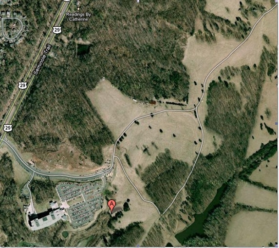
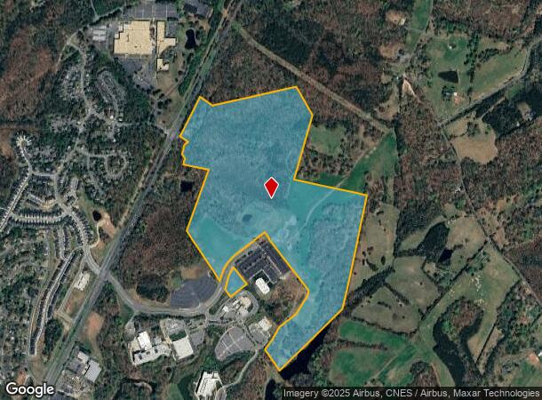
Property Record
2090 Boulders Rd, Charlottesville, VA 22911
NEARBY LISTINGS FOR SALE OR LEASE
Property Detail
2090 Boulders Rd
Charlottesville, VA
Commonwealth Land Surveying Ll
03300-00-00-001D0
ACREAGE
Vacantlandnec
Albemarle
AE
Virginia
51079C0200C
2
0
116.20 AC
2025
Charlottesville
010201
Other Market Areas
DEMOGRAPHICS near 2090 Boulders Rd
1 Mile
3 Mile
5 Mile
2024 Total Population
2,236
10,924
24,885
2029 Population
2,342
11,469
26,146
Pop Growth 2024-2029
+ 4.74%
+ 4.99%
+ 5.07%
Average Age
37
39
41
2024 Total Households
801
4,060
9,364
HH Growth 2024-2029
+ 5.12%
+ 5.34%
+ 5.34%
Median Household Inc
$91,958
$101,269
$104,330
Avg Household Size
2.70
2.60
2.60
2024 Avg HH Vehicles
3.00
2.00
2.00
Median Home Value
$250,195
$341,674
$359,501
Median Year Built
1992
1991
1992
Nearby Places
Map Layers
Map Styles
 Street
 Aerial
- Restaurants
- Banks
- Shops
- Fitness
- Groceries
PUBLIC TRANSPORTATION
AIRPORT
Charlottesville-Albemarle
DRIVE
WALK
Distance
Charlottesville-Albemarle
9 min
4.1 mi
Freight Ports
Virginia Port Authority - Richmond
DRIVE
WALK
Distance
Virginia Port Authority - Richmond
111 min
86.7 mi
SALE & LEASE HISTORY
LISTING DATE
SALE/LEASE

Sep 24, 2016
For Sale
Nearby Properties
Address
Land Use
TOTAL SIZE
Lot Size
Zoning
Address
Land Use
TOTAL SIZE
Lot Size
Zoning
188,275 SF
28.88 AC
LIGHT INDU
Address
Land Use
TOTAL SIZE
Lot Size
Zoning
20,000 SF
46.67 AC
RURAL AREA
Address
Land Use
TOTAL SIZE
Lot Size
Zoning
10.88 AC
UNASSIGNED
Address
Land Use
TOTAL SIZE
Lot Size
Zoning
36,136 SF
626.08 AC
RURAL AREA
Address
Land Use
TOTAL SIZE
Lot Size
Zoning
90,576 SF
5.72 AC
COMMERCIAL
Address
Land Use
TOTAL SIZE
Lot Size
Zoning
85,591 SF
52.56 AC
RURAL AREA
Address
Land Use
TOTAL SIZE
Lot Size
Zoning
109,373 SF
50.26 AC
LIGHT INDU
Address
Land Use
TOTAL SIZE
Lot Size
Zoning
140,377 SF
9.84 AC
PLANNED DE
Address
Land Use
TOTAL SIZE
Lot Size
Zoning
467.52 AC
PDIP
Address
Land Use
TOTAL SIZE
Lot Size
Zoning
82,068 SF
4.33 AC
PLANNED DE
Address
Land Use
TOTAL SIZE
Lot Size
Zoning
74,213 SF
2.02 AC
PDMC
Address
Land Use
TOTAL SIZE
Lot Size
Zoning
79,032 SF
4.67 AC
PLANNED DE
Address
Land Use
TOTAL SIZE
Lot Size
Zoning
44,116 SF
4.05 AC
HIGHWAY CO
Address
Land Use
TOTAL SIZE
Lot Size
Zoning
2,904 SF
5.76 AC
HIGHWAY CO
Address
Land Use
TOTAL SIZE
Lot Size
Zoning
72,670 SF
9.36 AC
LIGHT INDU
Address
Land Use
TOTAL SIZE
Lot Size
Zoning
49,580 SF
13.16 AC
LIGHT INDU
Address
Land Use
TOTAL SIZE
Lot Size
Zoning
45,601 SF
1.97 AC
PDMC
Address
Land Use
TOTAL SIZE
Lot Size
Zoning
4,536 SF
1.44 AC
HIGHWAY CO
Address
Land Use
TOTAL SIZE
Lot Size
Zoning
7,606 SF
6.41 AC
LIGHT INDU
Address
Land Use
TOTAL SIZE
Lot Size
Zoning
70,974 SF
4.77 AC
PLANNED DE
Address
Land Use
TOTAL SIZE
Lot Size
Zoning
24,228 SF
4.62 AC
RURAL AREA
Address
Land Use
TOTAL SIZE
Lot Size
Zoning
80,400 SF
16.80 AC
LIGHT INDU
Address
Land Use
TOTAL SIZE
Lot Size
Zoning
15,972 SF
2.63 AC
PLANNED DE
Address
Land Use
TOTAL SIZE
Lot Size
Zoning
41,746 SF
2.60 AC
PLANNED DE
Address
Land Use
TOTAL SIZE
Lot Size
Zoning
12,640 SF
25.98 AC
R4 RESIDEN
Address
Land Use
TOTAL SIZE
Lot Size
Zoning
14,830 SF
2.01 AC
HIGHWAY CO
Address
Land Use
TOTAL SIZE
Lot Size
Zoning
45,683 SF
6.19 AC
PLANNED DE
Address
Land Use
TOTAL SIZE
Lot Size
Zoning
2.35 AC
C1 COMMERC
The World's #1 Commercial Real Estate Marketplace
Connect with us
© 2026 CoStar Group
The information above has been obtained from sources believed reliable. While we do not doubt its accuracy we have not verified it and make no guarantee, warranty or representation about it. It is your responsibility to independently confirm its accuracy and completeness. Any projections, opinions, assumptions, or estimates used are for example only and do not represent the current or future performance of the property. The value of this transaction to you depends on tax and other factors which should be evaluated by your tax, financial, and legal advisors. You and your advisors should conduct a careful, independent investigation of the property to determine to your satisfaction the suitability of the property for your needs.