Property Record
2090 N Cable Rd, Lima, OH 45805
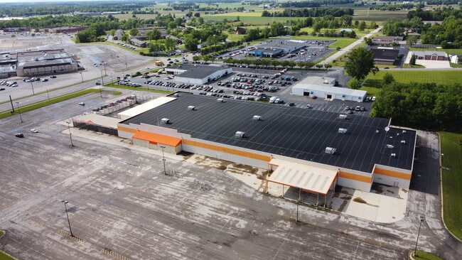

Property Detail
2090 N Cable Rd
Lima, OH
THE HOME ACRES SUBURBAN ALLOTMENT LOT 8474 & PT SW1/4 RTS 06-03-23
36-23-10-02-017.000
Allen
Storebuilding
Ohio
B and X Area of moderate flood hazard, usually the area between the limits of the 100-year and 500-year floods.
8474
2024
35.45 AC
2024
Lima/Findlay
011000
Other Market Areas
97,410 SF
NEARBY LISTINGS FOR SALE OR LEASE
DEMOGRAPHICS near 2090 N Cable Rd
1 mile
3 mile
5 mile
2025 Total Population
5,710
40,674
64,658
2030 Population
5,727
40,517
64,394
Pop Growth 2025-2030
+ 0.30%
(0.39%)
(0.41%)
Average Age
42
40
40
2025 Total Households
2,686
16,674
26,236
HH Growth 2025-2030
+ 0.30%
(0.45%)
(0.50%)
Median Household Inc
$56,889
$56,534
$60,083
Avg Household Size
2.00
2.20
2.30
2025 Avg HH Vehicles
2.00
2.00
2.00
Median Home Value
$150,424
$148,182
$161,920
Median Year Built
1973
1962
1963
Nearby Places
Map Layers
Map Styles
 Street
 Aerial
Transit
 Traffic
 Biking
Places
Listings with unknown addresses are not visible on the map
- Restaurants
- Banks
- Shops
- Fitness
- Groceries
SALE & LEASE HISTORY
LISTING DATE
SALE/LEASE

Sep 23, 2016
For Sale
May 29, 2018
For Lease
Mar 21, 2017
For Lease
Mar 10, 2017
For Sale
Jun 11, 2021
For Sale
Jul 25, 2024
For Sale
Dec 13, 2017
For Sale
Nearby Properties
Address
Land Use
TOTAL SIZE
Lot Size
Zoning
Address
Land Use
TOTAL SIZE
Lot Size
Zoning
628,932 SF
9.08 AC
Address
Land Use
TOTAL SIZE
Lot Size
Zoning
242,023 SF
3.81 AC
Address
Land Use
TOTAL SIZE
Lot Size
Zoning
209,864 SF
87.96 AC
Address
Land Use
TOTAL SIZE
Lot Size
Zoning
5,520 SF
12.99 AC
Address
Land Use
TOTAL SIZE
Lot Size
Zoning
75,197 SF
45.82 AC
Address
Land Use
TOTAL SIZE
Lot Size
Zoning
150,414 SF
40.04 AC
Address
Land Use
TOTAL SIZE
Lot Size
Zoning
523,578 SF
468.55 AC
Address
Land Use
TOTAL SIZE
Lot Size
Zoning
104,798 SF
0.94 AC
Address
Land Use
TOTAL SIZE
Lot Size
Zoning
62,626 SF
5.16 AC
Address
Land Use
TOTAL SIZE
Lot Size
Zoning
16,992 SF
21.86 AC
Address
Land Use
TOTAL SIZE
Lot Size
Zoning
652,254 SF
46.12 AC
Address
Land Use
TOTAL SIZE
Lot Size
Zoning
134,124 SF
29.04 AC
Address
Land Use
TOTAL SIZE
Lot Size
Zoning
253,944 SF
27.50 AC
Address
Land Use
TOTAL SIZE
Lot Size
Zoning
177,998 SF
22.49 AC
Address
Land Use
TOTAL SIZE
Lot Size
Zoning
50,497 SF
38.72 AC
Address
Land Use
TOTAL SIZE
Lot Size
Zoning
70,067 SF
9.50 AC
Address
Land Use
TOTAL SIZE
Lot Size
Zoning
101,362 SF
2.78 AC
Address
Land Use
TOTAL SIZE
Lot Size
Zoning
204,050 SF
43.36 AC
Address
Land Use
TOTAL SIZE
Lot Size
Zoning
62,566 SF
13 AC
Address
Land Use
TOTAL SIZE
Lot Size
Zoning
65,986 SF
6.50 AC
Address
Land Use
TOTAL SIZE
Lot Size
Zoning
87,128 SF
1.89 AC
Address
Land Use
TOTAL SIZE
Lot Size
Zoning
171,264 SF
22.05 AC
Address
Land Use
TOTAL SIZE
Lot Size
Zoning
100,154 SF
2.39 AC
Address
Land Use
TOTAL SIZE
Lot Size
Zoning
253,300 SF
1.08 AC
Address
Land Use
TOTAL SIZE
Lot Size
Zoning
90,019 SF
7.14 AC
Address
Land Use
TOTAL SIZE
Lot Size
Zoning
121,699 SF
13.49 AC
Address
Land Use
TOTAL SIZE
Lot Size
Zoning
98,606 SF
9.42 AC
Address
Land Use
TOTAL SIZE
Lot Size
Zoning
84,488 SF
8.21 AC
Address
Land Use
TOTAL SIZE
Lot Size
Zoning
115,935 SF
10.10 AC
Address
Land Use
TOTAL SIZE
Lot Size
Zoning
23,968 SF
18 AC
The World's #1 Commercial Real Estate Marketplace
Connect with us
© 2026 CoStar Group
The information above has been obtained from sources believed reliable. While we do not doubt its accuracy we have not verified it and make no guarantee, warranty or representation about it. It is your responsibility to independently confirm its accuracy and completeness. Any projections, opinions, assumptions, or estimates used are for example only and do not represent the current or future performance of the property. The value of this transaction to you depends on tax and other factors which should be evaluated by your tax, financial, and legal advisors. You and your advisors should conduct a careful, independent investigation of the property to determine to your satisfaction the suitability of the property for your needs.