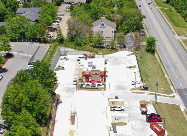
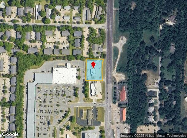
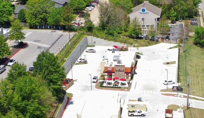
Property Record
2091 N Crossover Rd, Fayetteville, AR 72703
NEARBY LISTINGS FOR SALE OR LEASE
Property Detail
2091 N Crossover Rd
Fayetteville-Springdale-Rogers, AR
Fayetteville Outlots
765-13334-011
PT NE SE 0.85 AC FURTHER DESCRIBED PER 2017-37410: TRACT 1: A PART OF THE NE 1/4 OF THE SE 1/4 OF SECTION 2, TOWNSHIP 16 NORT
Restaurantdrivein
Washington
X
Arkansas
05143C0230G
1
2025
0.85 AC
2025
Greater Fayetteville
010107
Fayetteville/Springdale/Rogers
2,896 SF
DEMOGRAPHICS near 2091 N Crossover Rd
1 Mile
3 Mile
5 Mile
2024 Total Population
7,083
46,136
108,827
2029 Population
7,766
50,539
118,813
Pop Growth 2024-2029
+ 9.64%
+ 9.54%
+ 9.18%
Average Age
39
37
35
2024 Total Households
2,870
20,542
44,211
HH Growth 2024-2029
+ 10.00%
+ 9.80%
+ 9.83%
Median Household Inc
$86,633
$58,931
$60,876
Avg Household Size
2.40
2.10
2.20
2024 Avg HH Vehicles
2.00
2.00
2.00
Median Home Value
$314,348
$320,811
$279,419
Median Year Built
1992
1990
1994
Nearby Places
Map Layers
Map Styles
 Street
 Aerial
- Restaurants
- Banks
- Shops
- Fitness
- Groceries
PUBLIC TRANSPORTATION
AIRPORT
Northwest Arkansas Ntl
DRIVE
WALK
Distance
Northwest Arkansas Ntl
45 min
22.8 mi
Freight Ports
Tulsa Port of Inola
DRIVE
WALK
Distance
Tulsa Port of Inola
113 min
94.1 mi
SALE & LEASE HISTORY
LISTING DATE
SALE/LEASE

Mar 10, 2022
For Sale
Nearby Properties
Address
Land Use
TOTAL SIZE
Lot Size
Zoning
Address
Land Use
TOTAL SIZE
Lot Size
Zoning
153,698 SF
14.10 AC
C2
Address
Land Use
TOTAL SIZE
Lot Size
Zoning
23,707 SF
15.45 AC
R2
Address
Land Use
TOTAL SIZE
Lot Size
Zoning
238,168 SF
Address
Land Use
TOTAL SIZE
Lot Size
Zoning
50,708 SF
1.69 AC
C2
Address
Land Use
TOTAL SIZE
Lot Size
Zoning
191,928 SF
0.81 AC
C4
Address
Land Use
TOTAL SIZE
Lot Size
Zoning
62,644 SF
0.49 AC
R3
Address
Land Use
TOTAL SIZE
Lot Size
Zoning
232,212 SF
10.31 AC
Address
Land Use
TOTAL SIZE
Lot Size
Zoning
305,272 SF
9.66 AC
R2
Address
Land Use
TOTAL SIZE
Lot Size
Zoning
48,120 SF
0.53 AC
R3
Address
Land Use
TOTAL SIZE
Lot Size
Zoning
86,794 SF
0.33 AC
Address
Land Use
TOTAL SIZE
Lot Size
Zoning
6,798 SF
10.56 AC
Address
Land Use
TOTAL SIZE
Lot Size
Zoning
41,952 SF
19.26 AC
Address
Land Use
TOTAL SIZE
Lot Size
Zoning
19,805 SF
0.35 AC
R0
Address
Land Use
TOTAL SIZE
Lot Size
Zoning
78,284 SF
0.43 AC
Address
Land Use
TOTAL SIZE
Lot Size
Zoning
99,793 SF
6.98 AC
Address
Land Use
TOTAL SIZE
Lot Size
Zoning
178,014 SF
6.43 AC
Address
Land Use
TOTAL SIZE
Lot Size
Zoning
261,670 SF
16.72 AC
R2
Address
Land Use
TOTAL SIZE
Lot Size
Zoning
217,873 SF
24.10 AC
C2
Address
Land Use
TOTAL SIZE
Lot Size
Zoning
40,501 SF
1.13 AC
R0
Address
Land Use
TOTAL SIZE
Lot Size
Zoning
56,672 SF
0.53 AC
R0
Address
Land Use
TOTAL SIZE
Lot Size
Zoning
64,659 SF
4.99 AC
R0
Address
Land Use
TOTAL SIZE
Lot Size
Zoning
71,336 SF
6.24 AC
Address
Land Use
TOTAL SIZE
Lot Size
Zoning
20,646 SF
2.45 AC
C2
Address
Land Use
TOTAL SIZE
Lot Size
Zoning
206,047 SF
26.94 AC
R1
Address
Land Use
TOTAL SIZE
Lot Size
Zoning
49,883 SF
1.38 AC
R2
Address
Land Use
TOTAL SIZE
Lot Size
Zoning
66,120 SF
1.95 AC
Address
Land Use
TOTAL SIZE
Lot Size
Zoning
174,848 SF
27.32 AC
R1
Address
Land Use
TOTAL SIZE
Lot Size
Zoning
72,162 SF
3.31 AC
Address
Land Use
TOTAL SIZE
Lot Size
Zoning
55,877 SF
6.43 AC
C2
Address
Land Use
TOTAL SIZE
Lot Size
Zoning
46,181 SF
0.39 AC
R3
The World's #1 Commercial Real Estate Marketplace
Connect with us
© 2026 CoStar Group
The information above has been obtained from sources believed reliable. While we do not doubt its accuracy we have not verified it and make no guarantee, warranty or representation about it. It is your responsibility to independently confirm its accuracy and completeness. Any projections, opinions, assumptions, or estimates used are for example only and do not represent the current or future performance of the property. The value of this transaction to you depends on tax and other factors which should be evaluated by your tax, financial, and legal advisors. You and your advisors should conduct a careful, independent investigation of the property to determine to your satisfaction the suitability of the property for your needs.