Property Record
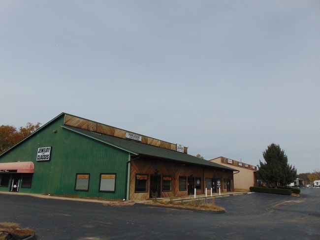
2091 Us Highway 67, Festus, MO 63028


Property Detail
2091 Us Highway 67
18-6.0-23.0-0-000-011.12
BERWIN BUSINESS CENTER LOTS 1 & 2 & BERWIN BUSINESS CENTER BDRY ADJ LOT 3A (2020P-000008)
Storebuilding
Jefferson
CC2
Missouri
AE The base floodplain where base flood elevations are provided. AE Zones are now used on new format FIRMs instead of A1-A30 Zones.
1-2,3
2024
4.66 AC
2025
Outer Jefferson Cnty
700900
St. Louis
15,800 SF
St. Louis, MO-IL
NEARBY LISTINGS FOR SALE OR LEASE
DEMOGRAPHICS near 2091 Us Highway 67
1 mile
3 mile
5 mile
2025 Total Population
627
11,746
32,575
2030 Population
646
12,052
33,378
Pop Growth 2025-2030
+ 3.03%
+ 2.61%
+ 2.47%
Average Age
44
42
41
2025 Total Households
235
4,529
12,613
HH Growth 2025-2030
+ 3.40%
+ 2.56%
+ 2.47%
Median Household Inc
$96,874
$80,762
$75,086
Avg Household Size
2.60
2.50
2.50
2025 Avg HH Vehicles
2.00
2.00
2.00
Median Home Value
$272,972
$232,996
$216,306
Median Year Built
1986
1991
1984
Nearby Places
Map Layers
Map Styles
 Street
 Aerial
Layers
 Traffic
 Biking
Places
Listings with unknown addresses are not visible on the map
- Restaurants
- Banks
- Shops
- Fitness
- Groceries
SALE & LEASE HISTORY
LISTING DATE
SALE/LEASE

Oct 21, 2019
For Sale
Jan 05, 2021
For Sale
Nearby Properties
Address
Land Use
TOTAL SIZE
Lot Size
Zoning
Address
Land Use
TOTAL SIZE
Lot Size
Zoning
142,041 SF
27.01 AC
CT1
Address
Land Use
TOTAL SIZE
Lot Size
Zoning
139,741 SF
15.23 AC
CT1
Address
Land Use
TOTAL SIZE
Lot Size
Zoning
134,303 SF
17.10 AC
Address
Land Use
TOTAL SIZE
Lot Size
Zoning
109,828 SF
9.43 AC
Address
Land Use
TOTAL SIZE
Lot Size
Zoning
52,728 SF
5.38 AC
CT1
Address
Land Use
TOTAL SIZE
Lot Size
Zoning
52,408 SF
4.94 AC
Address
Land Use
TOTAL SIZE
Lot Size
Zoning
29,714 SF
2.78 AC
Address
Land Use
TOTAL SIZE
Lot Size
Zoning
33,437 SF
3.04 AC
CT1
Address
Land Use
TOTAL SIZE
Lot Size
Zoning
95,998 SF
2.39 AC
CT1
Address
Land Use
TOTAL SIZE
Lot Size
Zoning
11,764 SF
1.08 AC
CT1
Address
Land Use
TOTAL SIZE
Lot Size
Zoning
3,840 SF
4.51 AC
CT1
Address
Land Use
TOTAL SIZE
Lot Size
Zoning
16,932 SF
1.59 AC
CT1
Address
Land Use
TOTAL SIZE
Lot Size
Zoning
35,093 SF
2.56 AC
CT1
Address
Land Use
TOTAL SIZE
Lot Size
Zoning
81,026 SF
7.01 AC
CT1
Address
Land Use
TOTAL SIZE
Lot Size
Zoning
45,205 SF
1.39 AC
CT1
Address
Land Use
TOTAL SIZE
Lot Size
Zoning
9,600 SF
1.50 AC
CT1
Address
Land Use
TOTAL SIZE
Lot Size
Zoning
19,322 SF
2.30 AC
CT1
Address
Land Use
TOTAL SIZE
Lot Size
Zoning
14,034 SF
2.08 AC
CT1
Address
Land Use
TOTAL SIZE
Lot Size
Zoning
71,345 SF
4.62 AC
CC2
Address
Land Use
TOTAL SIZE
Lot Size
Zoning
26,846 SF
4 AC
CT1
Address
Land Use
TOTAL SIZE
Lot Size
Zoning
50,421 SF
104.96 AC
LR2
Address
Land Use
TOTAL SIZE
Lot Size
Zoning
969 SF
128.78 AC
R40
Address
Land Use
TOTAL SIZE
Lot Size
Zoning
42,104 SF
11.62 AC
CT1
Address
Land Use
TOTAL SIZE
Lot Size
Zoning
16,074 SF
7.07 AC
CC2
Address
Land Use
TOTAL SIZE
Lot Size
Zoning
8,263 SF
2.49 AC
Address
Land Use
TOTAL SIZE
Lot Size
Zoning
41,920 SF
4.07 AC
CT1
Address
Land Use
TOTAL SIZE
Lot Size
Zoning
7,809 SF
1.32 AC
CT1
Address
Land Use
TOTAL SIZE
Lot Size
Zoning
7,218 SF
0.89 AC
CT1
Address
Land Use
TOTAL SIZE
Lot Size
Zoning
15,075 SF
1.34 AC
Address
Land Use
TOTAL SIZE
Lot Size
Zoning
31,795 SF
1.78 AC
The World's #1 Commercial Real Estate Marketplace
Connect with us
© 2026 CoStar Group
The information above has been obtained from sources believed reliable. While we do not doubt its accuracy we have not verified it and make no guarantee, warranty or representation about it. It is your responsibility to independently confirm its accuracy and completeness. Any projections, opinions, assumptions, or estimates used are for example only and do not represent the current or future performance of the property. The value of this transaction to you depends on tax and other factors which should be evaluated by your tax, financial, and legal advisors. You and your advisors should conduct a careful, independent investigation of the property to determine to your satisfaction the suitability of the property for your needs.