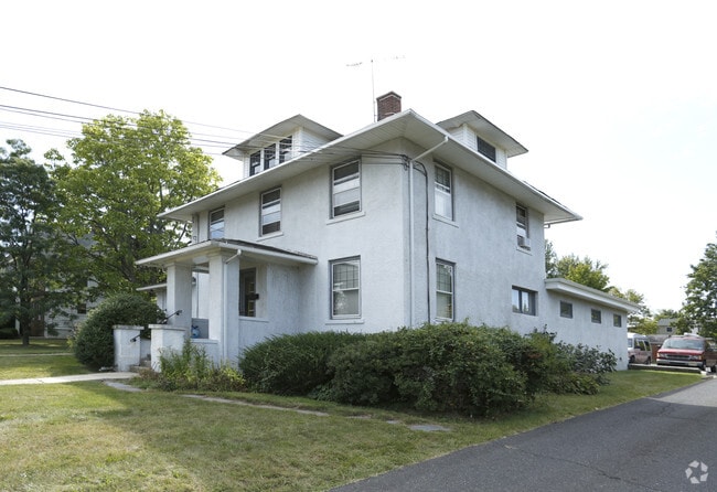
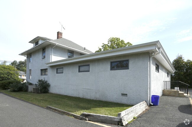
Property Record
20937 W Thomas Rd, Buckeye, AZ 85396
NEARBY LISTINGS FOR SALE OR LEASE
Property Detail
20937 W Thomas Rd
18-00048-0000-00013
J H Lords Bldg
Vacantlandnec
Somerset
X
New Jersey
34035C0153E
13
2024
0.46 AC
2025
Route 22 West
050400
Northern New Jersey
3,502 SF
Lakewood-New Brunswick, NJ
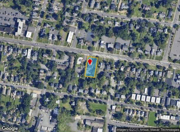
DEMOGRAPHICS near 20937 W Thomas Rd
1 mile
3 mile
5 mile
2024 Total Population
13,402
60,044
135,134
2029 Population
13,695
60,302
135,259
Pop Growth 2024-2029
+ 2.19%
+ 0.43%
+ 0.09%
Average Age
39
41
42
2024 Total Households
5,246
22,710
50,304
HH Growth 2024-2029
+ 2.31%
+ 0.52%
+ 0.12%
Median Household Inc
$98,441
$97,879
$113,776
Avg Household Size
2.40
2.60
2.60
2024 Avg HH Vehicles
2.00
2.00
2.00
Median Home Value
$353,673
$377,761
$438,103
Median Year Built
1962
1966
1975
Nearby Places
Map Layers
Map Styles
 Street
 Aerial
Transit
 Traffic
 Biking
Places
Listings with unknown addresses are not visible on the map
- Restaurants
- Banks
- Shops
- Fitness
- Groceries
PUBLIC TRANSPORTATION
COMMUTER RAIL
Somerville (Raritan Valley Line - NJ Transit Commuter Rail (NJ Transit))
Drive
Walk
Distance
Somerville (Raritan Valley Line - NJ Transit Commuter Rail (NJ Transit))
3 min
16 min
0.9 mi
Raritan (Raritan Valley Line - NJ Transit Commuter Rail (NJ Transit))
Drive
Walk
Distance
Raritan (Raritan Valley Line - NJ Transit Commuter Rail (NJ Transit))
6 min
2.1 mi
AIRPORT
Trenton Mercer
Drive
Walk
Distance
Trenton Mercer
50 min
30.4 mi
Newark Liberty International
Drive
Walk
Distance
Newark Liberty International
43 min
30.6 mi
Freight Ports
New York Container Terminal
Drive
Walk
Distance
New York Container Terminal
41 min
31.5 mi
SALE & LEASE HISTORY
LISTING DATE
SALE/LEASE

Sep 27, 2018
For Lease
Sep 24, 2016
For Sale
Oct 03, 2018
For Sale
Nov 27, 2017
For Lease
Nov 17, 2017
For Lease
Mar 12, 2024
For Lease
Jul 22, 2024
For Sale
Nearby Properties
Address
Land Use
TOTAL SIZE
Lot Size
Zoning
Address
Land Use
TOTAL SIZE
Lot Size
Zoning
26.42 AC
C2
Address
Land Use
TOTAL SIZE
Lot Size
Zoning
108.74 AC
OM-3
Address
Land Use
TOTAL SIZE
Lot Size
Zoning
13.59 AC
H
Address
Land Use
TOTAL SIZE
Lot Size
Zoning
70.22 AC
B-I
Address
Land Use
TOTAL SIZE
Lot Size
Zoning
39.10 AC
C3
Address
Land Use
TOTAL SIZE
Lot Size
Zoning
22.36 AC
PAC
Address
Land Use
TOTAL SIZE
Lot Size
Zoning
22.75 AC
LC
Address
Land Use
TOTAL SIZE
Lot Size
Zoning
153 AC
Address
Land Use
TOTAL SIZE
Lot Size
Zoning
25.70 AC
PACD
Address
Land Use
TOTAL SIZE
Lot Size
Zoning
81.89 AC
M1
Address
Land Use
TOTAL SIZE
Lot Size
Zoning
26.23 AC
B-I
Address
Land Use
TOTAL SIZE
Lot Size
Zoning
32.92 AC
B-I
Address
Land Use
TOTAL SIZE
Lot Size
Zoning
Address
Land Use
TOTAL SIZE
Lot Size
Zoning
66.08 AC
M3
Address
Land Use
TOTAL SIZE
Lot Size
Zoning
34.80 AC
OM-3
Address
Land Use
TOTAL SIZE
Lot Size
Zoning
82.79 AC
M-2
Address
Land Use
TOTAL SIZE
Lot Size
Zoning
19.36 AC
M1
Address
Land Use
TOTAL SIZE
Lot Size
Zoning
19.34 AC
M1
Address
Land Use
TOTAL SIZE
Lot Size
Zoning
10.31 AC
PDRD
Address
Land Use
TOTAL SIZE
Lot Size
Zoning
2,488 SF
16.46 AC
PAC
Address
Land Use
TOTAL SIZE
Lot Size
Zoning
5.60 AC
CG
Address
Land Use
TOTAL SIZE
Lot Size
Zoning
8.26 AC
R40
Address
Land Use
TOTAL SIZE
Lot Size
Zoning
13.38 AC
B2
Address
Land Use
TOTAL SIZE
Lot Size
Zoning
1,056 SF
0.07 AC
Address
Land Use
TOTAL SIZE
Lot Size
Zoning
10.47 AC
C2
Address
Land Use
TOTAL SIZE
Lot Size
Zoning
9.91 AC
C2
Address
Land Use
TOTAL SIZE
Lot Size
Zoning
8.60 AC
C2
Address
Land Use
TOTAL SIZE
Lot Size
Zoning
394 SF
36.05 AC
M105
Address
Land Use
TOTAL SIZE
Lot Size
Zoning
43.63 AC
M1B
Address
Land Use
TOTAL SIZE
Lot Size
Zoning
19.95 AC
M1B
The World's #1 Commercial Real Estate Marketplace
Connect with us
© 2026 CoStar Group
The information above has been obtained from sources believed reliable. While we do not doubt its accuracy we have not verified it and make no guarantee, warranty or representation about it. It is your responsibility to independently confirm its accuracy and completeness. Any projections, opinions, assumptions, or estimates used are for example only and do not represent the current or future performance of the property. The value of this transaction to you depends on tax and other factors which should be evaluated by your tax, financial, and legal advisors. You and your advisors should conduct a careful, independent investigation of the property to determine to your satisfaction the suitability of the property for your needs.