Property Record
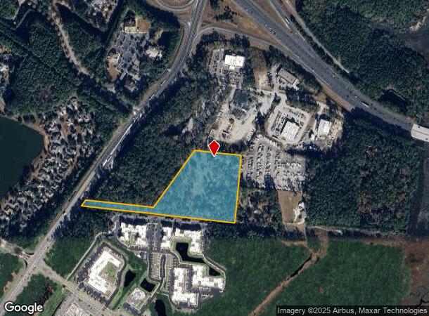
2094 Okatie Hwy, Okatie, SC 29909

NEARBY LISTINGS FOR SALE OR LEASE
Property Detail
2094 Okatie Hwy
Other Market Areas
Okatie Hwy-Fording Is Rd Comme
Hilton Head Island-Bluffton-Beaufort, SC
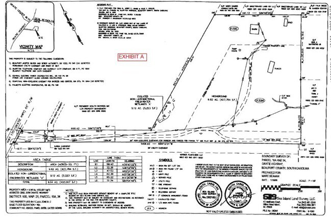
*TOT AC INCL 0.12 AC WETLAND PB31 PG98 PB54 PG96 PB107 PG186 PB117 PG95 SPLIT 4
R600-021-000-016A-0000
Beaufort
Commercialnec
South Carolina
2025
9.86 AC
2024
Hilton Head/Beaufort
002105
DEMOGRAPHICS near 2094 Okatie Hwy
1 Mile
3 Mile
5 Mile
2024 Total Population
1,654
31,225
59,764
2029 Population
1,835
35,444
67,997
Pop Growth 2024-2029
+ 10.94%
+ 13.51%
+ 13.78%
Average Age
57
51
47
2024 Total Households
786
13,459
24,659
HH Growth 2024-2029
+ 10.56%
+ 13.43%
+ 13.73%
Median Household Inc
$80,178
$78,994
$79,226
Avg Household Size
2.00
2.20
2.30
2024 Avg HH Vehicles
2.00
2.00
2.00
Median Home Value
$309,483
$362,891
$362,670
Median Year Built
1998
2006
2006
Nearby Places
Map Layers
Map Styles
 Street
 Aerial
- Restaurants
- Banks
- Shops
- Fitness
- Groceries
PUBLIC TRANSPORTATION
AIRPORT
Hilton Head
DRIVE
WALK
Distance
Hilton Head
27 min
17.5 mi
Savannah/Hilton Head International
DRIVE
WALK
Distance
Savannah/Hilton Head International
42 min
29.1 mi
Freight Ports
Georgia Ports - Savannah
DRIVE
WALK
Distance
Georgia Ports - Savannah
36 min
21.5 mi
SALE & LEASE HISTORY
LISTING DATE
SALE/LEASE

Jul 28, 2020
For Sale
Jul 22, 2019
For Sale
Dec 26, 2018
For Sale
Aug 07, 2019
For Sale
Nearby Properties
Address
Land Use
TOTAL SIZE
Lot Size
Zoning
Address
Land Use
TOTAL SIZE
Lot Size
Zoning
359,002 SF
29.31 AC
6106
Address
Land Use
TOTAL SIZE
Lot Size
Zoning
2.61 AC
RC
Address
Land Use
TOTAL SIZE
Lot Size
Zoning
1,248 SF
39.20 AC
PDD
Address
Land Use
TOTAL SIZE
Lot Size
Zoning
1,632 SF
18.20 AC
PDD
Address
Land Use
TOTAL SIZE
Lot Size
Zoning
1,632 SF
2.85 AC
PDD
Address
Land Use
TOTAL SIZE
Lot Size
Zoning
924 SF
17.76 AC
H2
Address
Land Use
TOTAL SIZE
Lot Size
Zoning
188,132 SF
10.59 AC
Address
Land Use
TOTAL SIZE
Lot Size
Zoning
90,696 SF
62.80 AC
6616
Address
Land Use
TOTAL SIZE
Lot Size
Zoning
26,844 SF
18.35 AC
6106
Address
Land Use
TOTAL SIZE
Lot Size
Zoning
696 SF
41.71 AC
6116
Address
Land Use
TOTAL SIZE
Lot Size
Zoning
67,941 SF
15.45 AC
Address
Land Use
TOTAL SIZE
Lot Size
Zoning
119,800 SF
9.37 AC
Address
Land Use
TOTAL SIZE
Lot Size
Zoning
56,327 SF
50.02 AC
6616
Address
Land Use
TOTAL SIZE
Lot Size
Zoning
Address
Land Use
TOTAL SIZE
Lot Size
Zoning
7.22 AC
Address
Land Use
TOTAL SIZE
Lot Size
Zoning
40,847 SF
3.79 AC
Address
Land Use
TOTAL SIZE
Lot Size
Zoning
81,625 SF
5.43 AC
Address
Land Use
TOTAL SIZE
Lot Size
Zoning
30,305 SF
0.93 AC
Address
Land Use
TOTAL SIZE
Lot Size
Zoning
38,694 SF
9.56 AC
Address
Land Use
TOTAL SIZE
Lot Size
Zoning
29,549 SF
17.88 AC
6106
Address
Land Use
TOTAL SIZE
Lot Size
Zoning
89,537 SF
12.29 AC
Address
Land Use
TOTAL SIZE
Lot Size
Zoning
76,410 SF
27.89 AC
6616
Address
Land Use
TOTAL SIZE
Lot Size
Zoning
65,592 SF
3.33 AC
6606
Address
Land Use
TOTAL SIZE
Lot Size
Zoning
65,544 SF
3.43 AC
Address
Land Use
TOTAL SIZE
Lot Size
Zoning
Address
Land Use
TOTAL SIZE
Lot Size
Zoning
3,296 SF
4.56 AC
PDD
Address
Land Use
TOTAL SIZE
Lot Size
Zoning
43,031 SF
5.92 AC
6606
Address
Land Use
TOTAL SIZE
Lot Size
Zoning
53,860 SF
3.49 AC
The World's #1 Commercial Real Estate Marketplace
Connect with us
© 2025 CoStar Group
The information above has been obtained from sources believed reliable. While we do not doubt its accuracy we have not verified it and make no guarantee, warranty or representation about it. It is your responsibility to independently confirm its accuracy and completeness. Any projections, opinions, assumptions, or estimates used are for example only and do not represent the current or future performance of the property. The value of this transaction to you depends on tax and other factors which should be evaluated by your tax, financial, and legal advisors. You and your advisors should conduct a careful, independent investigation of the property to determine to your satisfaction the suitability of the property for your needs.