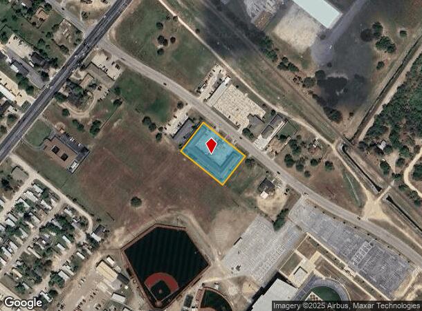
Property Record
2095 Woolam Rd, San Benito, TX 78586
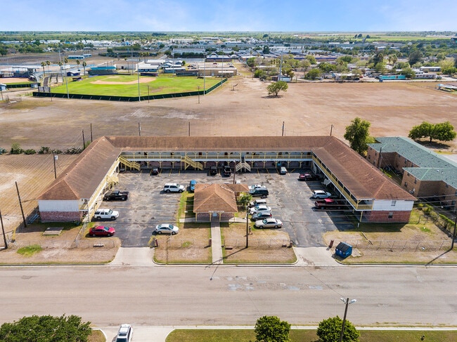
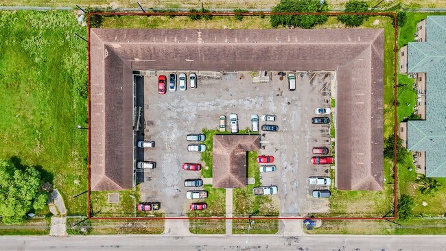
This Property Is For Sale
NEARBY LISTINGS FOR SALE OR LEASE
Property Detail
2095 Woolam Rd
Brownsville-Harlingen, TX
San Benito Land & Water Co Subd
610820-1240-009310
SAN BENITO LAND & WATER CO SUBD LOT 9 BLK 124 & 125, 1.2000 ACRES
Multifamilydwelling
Cameron
X
Texas
48061C0270F
9
2024
1.20 AC
2025
Outlying Cameron County
011701
Brownsville/Harlingen
24,886 SF
DEMOGRAPHICS near 2095 Woolam Rd
1 Mile
3 Mile
5 Mile
2024 Total Population
7,319
37,967
77,468
2029 Population
7,591
38,892
79,492
Pop Growth 2024-2029
+ 3.72%
+ 2.44%
+ 2.61%
Average Age
37
37
36
2024 Total Households
2,444
12,523
25,494
HH Growth 2024-2029
+ 3.72%
+ 2.27%
+ 2.54%
Median Household Inc
$35,838
$39,631
$41,581
Avg Household Size
2.90
2.90
2.90
2024 Avg HH Vehicles
2.00
2.00
2.00
Median Home Value
$64,611
$88,645
$85,975
Median Year Built
1982
1985
1983
Nearby Places
Map Layers
Map Styles
 Street
 Aerial
- Restaurants
- Banks
- Shops
- Fitness
- Groceries
PUBLIC TRANSPORTATION
AIRPORT
Valley International
DRIVE
WALK
Distance
Valley International
13 min
7.1 mi
Brownsville/South Padre Island International
DRIVE
WALK
Distance
Brownsville/South Padre Island International
32 min
23.8 mi
Freight Ports
Port of Brownsville
DRIVE
WALK
Distance
Port of Brownsville
25 min
21.4 mi
Nearby Properties
Address
Land Use
TOTAL SIZE
Lot Size
Zoning
Address
Land Use
TOTAL SIZE
Lot Size
Zoning
758,640 SF
11.31 AC
Address
Land Use
TOTAL SIZE
Lot Size
Zoning
427,448 SF
6.94 AC
Address
Land Use
TOTAL SIZE
Lot Size
Zoning
89,797 SF
7.90 AC
Address
Land Use
TOTAL SIZE
Lot Size
Zoning
186,716 SF
13.31 AC
C
Address
Land Use
TOTAL SIZE
Lot Size
Zoning
91,177 SF
40 AC
Address
Land Use
TOTAL SIZE
Lot Size
Zoning
159,787 SF
10.66 AC
Address
Land Use
TOTAL SIZE
Lot Size
Zoning
148,596 SF
1 AC
Address
Land Use
TOTAL SIZE
Lot Size
Zoning
118,561 SF
6.32 AC
C
Address
Land Use
TOTAL SIZE
Lot Size
Zoning
77,189 SF
3.28 AC
Address
Land Use
TOTAL SIZE
Lot Size
Zoning
70,340 SF
38.03 AC
AC
Address
Land Use
TOTAL SIZE
Lot Size
Zoning
62,764 SF
10 AC
Address
Land Use
TOTAL SIZE
Lot Size
Zoning
61,920 SF
5.60 AC
C
Address
Land Use
TOTAL SIZE
Lot Size
Zoning
155,425 SF
20.77 AC
C
Address
Land Use
TOTAL SIZE
Lot Size
Zoning
1,152 SF
44.60 AC
C
Address
Land Use
TOTAL SIZE
Lot Size
Zoning
138,862 SF
15.82 AC
Address
Land Use
TOTAL SIZE
Lot Size
Zoning
206,973 SF
12.77 AC
Address
Land Use
TOTAL SIZE
Lot Size
Zoning
230,267 SF
7.85 AC
C
Address
Land Use
TOTAL SIZE
Lot Size
Zoning
76,722 SF
8.26 AC
Address
Land Use
TOTAL SIZE
Lot Size
Zoning
180,838 SF
12.56 AC
C
Address
Land Use
TOTAL SIZE
Lot Size
Zoning
67,852 SF
34.12 AC
C
Address
Land Use
TOTAL SIZE
Lot Size
Zoning
78,223 SF
20.85 AC
Address
Land Use
TOTAL SIZE
Lot Size
Zoning
47,558 SF
7 AC
Address
Land Use
TOTAL SIZE
Lot Size
Zoning
42,557 SF
1.74 AC
C
Address
Land Use
TOTAL SIZE
Lot Size
Zoning
145,232 SF
6.38 AC
Address
Land Use
TOTAL SIZE
Lot Size
Zoning
84,936 SF
12 AC
Address
Land Use
TOTAL SIZE
Lot Size
Zoning
108,000 SF
10.44 AC
C
Address
Land Use
TOTAL SIZE
Lot Size
Zoning
151,926 SF
7.59 AC
Address
Land Use
TOTAL SIZE
Lot Size
Zoning
54,605 SF
25.70 AC
A-C
Address
Land Use
TOTAL SIZE
Lot Size
Zoning
55,573 SF
20 AC
C
Address
Land Use
TOTAL SIZE
Lot Size
Zoning
45,408 SF
12 AC
The World's #1 Commercial Real Estate Marketplace
Connect with us
© 2026 CoStar Group
The information above has been obtained from sources believed reliable. While we do not doubt its accuracy we have not verified it and make no guarantee, warranty or representation about it. It is your responsibility to independently confirm its accuracy and completeness. Any projections, opinions, assumptions, or estimates used are for example only and do not represent the current or future performance of the property. The value of this transaction to you depends on tax and other factors which should be evaluated by your tax, financial, and legal advisors. You and your advisors should conduct a careful, independent investigation of the property to determine to your satisfaction the suitability of the property for your needs.