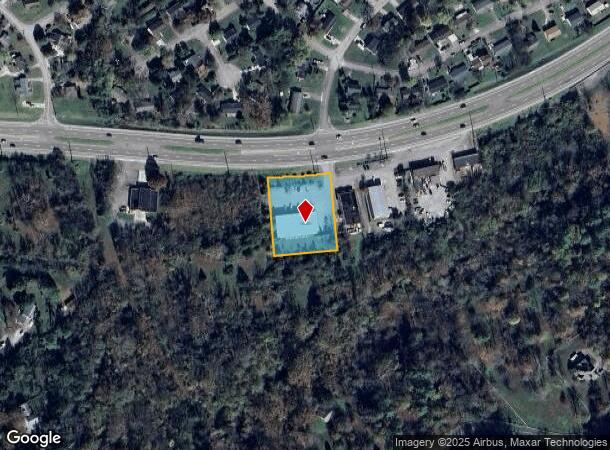
Property Record
2095 Oak Ridge Tpke, Oak Ridge, TN 37830

NEARBY LISTINGS FOR SALE OR LEASE
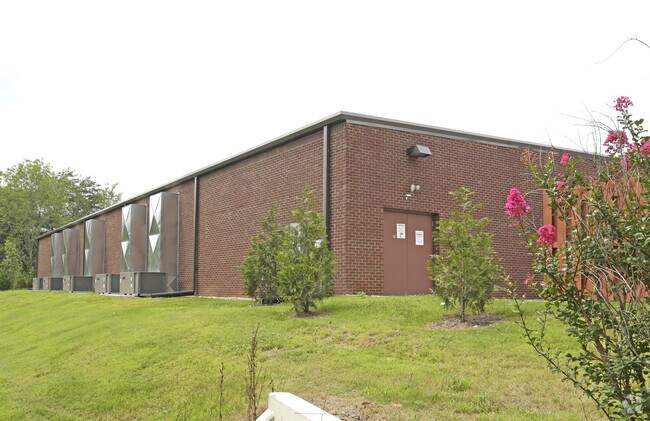
Property Detail
2095 Oak Ridge Tpke
Knoxville, TN
Dollar General Store
105H-A-001.01
DOLLAR GENERAL STORE PB: 9 PG: 15B LOT: 563.04
Commercialnec
Anderson
AE
Tennessee
47145C0135F
563.0
2024
1.12 AC
2025
Anderson County
020100
Knoxville
9,301 SF
DEMOGRAPHICS near 2095 Oak Ridge Tpke
1 Mile
3 Mile
5 Mile
2024 Total Population
2,844
19,994
34,404
2029 Population
2,997
21,268
36,638
Pop Growth 2024-2029
+ 5.38%
+ 6.37%
+ 6.49%
Average Age
41
41
42
2024 Total Households
1,164
8,584
14,682
HH Growth 2024-2029
+ 5.41%
+ 6.55%
+ 6.64%
Median Household Inc
$56,086
$55,008
$60,161
Avg Household Size
2.40
2.30
2.30
2024 Avg HH Vehicles
2.00
2.00
2.00
Median Home Value
$159,304
$176,287
$179,692
Median Year Built
1962
1963
1966
Nearby Places
Map Layers
Map Styles
 Street
 Aerial
- Restaurants
- Banks
- Shops
- Fitness
- Groceries
PUBLIC TRANSPORTATION
AIRPORT
McGhee Tyson
DRIVE
WALK
Distance
McGhee Tyson
36 min
27.1 mi
Freight Ports
Georgia Ports - Savannah
DRIVE
WALK
Distance
Georgia Ports - Savannah
506 min
439.6 mi
SALE & LEASE HISTORY
LISTING DATE
SALE/LEASE

Sep 16, 2020
For Sale
Apr 04, 2022
For Sale
Nearby Properties
Address
Land Use
TOTAL SIZE
Lot Size
Zoning
Address
Land Use
TOTAL SIZE
Lot Size
Zoning
11,464.16 AC
Address
Land Use
TOTAL SIZE
Lot Size
Zoning
233,514 SF
10.08 AC
Address
Land Use
TOTAL SIZE
Lot Size
Zoning
413,154 SF
4.10 AC
Address
Land Use
TOTAL SIZE
Lot Size
Zoning
96,668 SF
4.18 AC
Address
Land Use
TOTAL SIZE
Lot Size
Zoning
281,157 SF
31.49 AC
Address
Land Use
TOTAL SIZE
Lot Size
Zoning
112,672 SF
18.21 AC
Address
Land Use
TOTAL SIZE
Lot Size
Zoning
39,628 SF
1.06 AC
Address
Land Use
TOTAL SIZE
Lot Size
Zoning
108,723 SF
2.19 AC
Address
Land Use
TOTAL SIZE
Lot Size
Zoning
211,501 SF
15.36 AC
Address
Land Use
TOTAL SIZE
Lot Size
Zoning
49,728 SF
18.50 AC
Address
Land Use
TOTAL SIZE
Lot Size
Zoning
86,702 SF
8.20 AC
R3
Address
Land Use
TOTAL SIZE
Lot Size
Zoning
98,832 SF
4.77 AC
Address
Land Use
TOTAL SIZE
Lot Size
Zoning
53,109 SF
2.60 AC
Address
Land Use
TOTAL SIZE
Lot Size
Zoning
37,903 SF
6.09 AC
OF
Address
Land Use
TOTAL SIZE
Lot Size
Zoning
32,300 SF
4.17 AC
Address
Land Use
TOTAL SIZE
Lot Size
Zoning
36,035 SF
1 AC
Address
Land Use
TOTAL SIZE
Lot Size
Zoning
62,174 SF
2.14 AC
B2
Address
Land Use
TOTAL SIZE
Lot Size
Zoning
51,125 SF
4.20 AC
0
Address
Land Use
TOTAL SIZE
Lot Size
Zoning
177,824 SF
24.08 AC
R3
Address
Land Use
TOTAL SIZE
Lot Size
Zoning
50,976 SF
2.70 AC
Address
Land Use
TOTAL SIZE
Lot Size
Zoning
74,055 SF
8.64 AC
Address
Land Use
TOTAL SIZE
Lot Size
Zoning
55,475 SF
2.54 AC
Address
Land Use
TOTAL SIZE
Lot Size
Zoning
183,454 SF
11.07 AC
Address
Land Use
TOTAL SIZE
Lot Size
Zoning
128,195 SF
20.76 AC
R3
Address
Land Use
TOTAL SIZE
Lot Size
Zoning
14,135 SF
2.20 AC
Address
Land Use
TOTAL SIZE
Lot Size
Zoning
101,710 SF
7.77 AC
R3
Address
Land Use
TOTAL SIZE
Lot Size
Zoning
102,544 SF
9.49 AC
RG1
Address
Land Use
TOTAL SIZE
Lot Size
Zoning
102,760 SF
7.78 AC
R3
Address
Land Use
TOTAL SIZE
Lot Size
Zoning
134,479 SF
16.55 AC
R3
Address
Land Use
TOTAL SIZE
Lot Size
Zoning
14,680 SF
1.37 AC
B2
The World's #1 Commercial Real Estate Marketplace
Connect with us
© 2025 CoStar Group
The information above has been obtained from sources believed reliable. While we do not doubt its accuracy we have not verified it and make no guarantee, warranty or representation about it. It is your responsibility to independently confirm its accuracy and completeness. Any projections, opinions, assumptions, or estimates used are for example only and do not represent the current or future performance of the property. The value of this transaction to you depends on tax and other factors which should be evaluated by your tax, financial, and legal advisors. You and your advisors should conduct a careful, independent investigation of the property to determine to your satisfaction the suitability of the property for your needs.