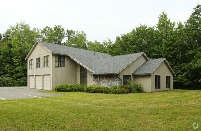
Property Record
2095 Route 9, Round Lake, NY 12151

NEARBY LISTINGS FOR SALE OR LEASE
Property Detail
2095 Route 9
Albany-Schenectady-Troy, NY
Saratoga
412400 250.-2-29
New York
Officebuilding
29.000
2024
6.39 AC
2024
Saratoga County
062501
Albany/Schenectady/Troy
5,220 SF
DEMOGRAPHICS near 2095 Route 9
1 Mile
3 Mile
5 Mile
2024 Total Population
1,670
19,456
51,250
2029 Population
1,719
19,990
52,827
Pop Growth 2024-2029
+ 2.93%
+ 2.74%
+ 3.08%
Average Age
43
42
43
2024 Total Households
651
7,874
21,400
HH Growth 2024-2029
+ 2.92%
+ 2.49%
+ 2.96%
Median Household Inc
$87,500
$101,670
$102,201
Avg Household Size
2.50
2.40
2.40
2024 Avg HH Vehicles
2.00
2.00
2.00
Median Home Value
$299,456
$336,977
$332,662
Median Year Built
1967
1981
1987
Nearby Places
Map Layers
Map Styles
 Street
 Aerial
- Restaurants
- Banks
- Shops
- Fitness
- Groceries
PUBLIC TRANSPORTATION
AIRPORT
Albany International
DRIVE
WALK
Distance
Albany International
20 min
14.5 mi
Freight Ports
Albany, NY Port
DRIVE
WALK
Distance
Albany, NY Port
35 min
24.9 mi
SALE & LEASE HISTORY
LISTING DATE
SALE/LEASE

Oct 18, 2018
For Lease
Jun 22, 2017
For Lease
Nearby Properties
Address
Land Use
TOTAL SIZE
Lot Size
Zoning
Address
Land Use
TOTAL SIZE
Lot Size
Zoning
11,884 SF
25.60 AC
RA-3
Address
Land Use
TOTAL SIZE
Lot Size
Zoning
3,030 SF
17.71 AC
PDD
Address
Land Use
TOTAL SIZE
Lot Size
Zoning
310,018 SF
58.71 AC
PDD
Address
Land Use
TOTAL SIZE
Lot Size
Zoning
952 SF
103.36 AC
Address
Land Use
TOTAL SIZE
Lot Size
Zoning
7,000 SF
16.50 AC
PDD
Address
Land Use
TOTAL SIZE
Lot Size
Zoning
5,400 SF
20.87 AC
PDD
Address
Land Use
TOTAL SIZE
Lot Size
Zoning
341,411 SF
62.74 AC
05 - COMME
Address
Land Use
TOTAL SIZE
Lot Size
Zoning
14,694 SF
24.67 AC
PDD
Address
Land Use
TOTAL SIZE
Lot Size
Zoning
14,694 SF
20.87 AC
PDD
Address
Land Use
TOTAL SIZE
Lot Size
Zoning
163,464 SF
7.06 AC
R67W
Address
Land Use
TOTAL SIZE
Lot Size
Zoning
14,694 SF
10.75 AC
PDD
Address
Land Use
TOTAL SIZE
Lot Size
Zoning
74,400 SF
10.68 AC
PDD
Address
Land Use
TOTAL SIZE
Lot Size
Zoning
4,437 SF
9.18 AC
PDD
Address
Land Use
TOTAL SIZE
Lot Size
Zoning
5,248 SF
16.35 AC
PDD
Address
Land Use
TOTAL SIZE
Lot Size
Zoning
120,000 SF
PDD
Address
Land Use
TOTAL SIZE
Lot Size
Zoning
4,437 SF
11.06 AC
PDD
Address
Land Use
TOTAL SIZE
Lot Size
Zoning
46,800 SF
9.70 AC
Address
Land Use
TOTAL SIZE
Lot Size
Zoning
7,000 SF
7.41 AC
PDD
Address
Land Use
TOTAL SIZE
Lot Size
Zoning
57,616 SF
11 AC
PDD
Address
Land Use
TOTAL SIZE
Lot Size
Zoning
7,000 SF
5.87 AC
R1
Address
Land Use
TOTAL SIZE
Lot Size
Zoning
53,240 SF
9.80 AC
07 - MIXED
Address
Land Use
TOTAL SIZE
Lot Size
Zoning
81,464 SF
39.81 AC
PDD
Address
Land Use
TOTAL SIZE
Lot Size
Zoning
105,750 SF
3.71 AC
R1-C2
Address
Land Use
TOTAL SIZE
Lot Size
Zoning
5,100 SF
9.25 AC
PDD
Address
Land Use
TOTAL SIZE
Lot Size
Zoning
28,036 SF
3.33 AC
C2 PDD
Address
Land Use
TOTAL SIZE
Lot Size
Zoning
11,676 SF
15.36 AC
R67W
Address
Land Use
TOTAL SIZE
Lot Size
Zoning
32,352 SF
10.61 AC
PDD
Address
Land Use
TOTAL SIZE
Lot Size
Zoning
4,437 SF
6.09 AC
PDD
Address
Land Use
TOTAL SIZE
Lot Size
Zoning
7,000 SF
4.25 AC
PDD
Address
Land Use
TOTAL SIZE
Lot Size
Zoning
2.75 AC
PDD
The World's #1 Commercial Real Estate Marketplace
Connect with us
© 2025 CoStar Group
The information above has been obtained from sources believed reliable. While we do not doubt its accuracy we have not verified it and make no guarantee, warranty or representation about it. It is your responsibility to independently confirm its accuracy and completeness. Any projections, opinions, assumptions, or estimates used are for example only and do not represent the current or future performance of the property. The value of this transaction to you depends on tax and other factors which should be evaluated by your tax, financial, and legal advisors. You and your advisors should conduct a careful, independent investigation of the property to determine to your satisfaction the suitability of the property for your needs.