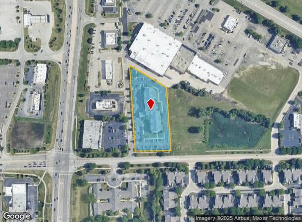
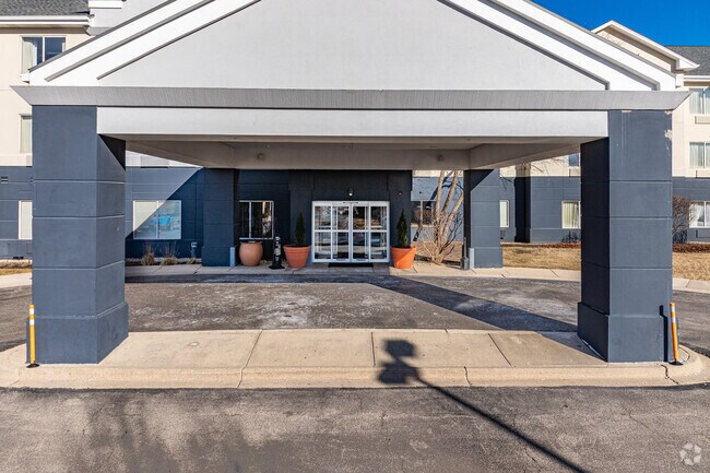
Property Record
2096 Bricher Rd, Saint Charles, IL 60174

NEARBY LISTINGS FOR SALE OR LEASE
-
-
View all Saint Charles listings for sale on LoopNet.com
Property Detail
2096 Bricher Rd
Chicago-Naperville-Elgin, IL-IN-WI
Stc Commercial Cntr
09-33-351-036
MAP AREA: 153-HOTEL/MOTEL
Commercialnec
Kane
X
Illinois
17089C0264H
1
2024
2.27 AC
2024
Chicago Southwest
852201
Chicago
15,442 SF
DEMOGRAPHICS near 2096 Bricher Rd
1 Mile
3 Mile
5 Mile
2024 Total Population
11,267
56,707
102,643
2029 Population
11,295
56,319
101,371
Pop Growth 2024-2029
+ 0.25%
(0.68%)
(1.24%)
Average Age
40
42
42
2024 Total Households
4,393
22,065
38,382
HH Growth 2024-2029
+ 0.27%
(0.71%)
(1.19%)
Median Household Inc
$111,161
$121,208
$125,218
Avg Household Size
2.50
2.50
2.60
2024 Avg HH Vehicles
2.00
2.00
2.00
Median Home Value
$352,908
$362,964
$373,674
Median Year Built
1986
1984
1987
Nearby Places
Map Layers
Map Styles
 Street
 Aerial
- Restaurants
- Banks
- Shops
- Fitness
- Groceries
PUBLIC TRANSPORTATION
COMMUTER RAIL
Geneva Station (Union Pacific West Line - Northeast Illinois Regional Commuter Railroad (Metra))
DRIVE
WALK
Distance
Geneva Station (Union Pacific West Line - Northeast Illinois Regional Commuter Railroad (Metra))
6 min
2.5 mi
La Fox Station (Union Pacific West Line - Northeast Illinois Regional Commuter Railroad (Metra))
DRIVE
WALK
Distance
La Fox Station (Union Pacific West Line - Northeast Illinois Regional Commuter Railroad (Metra))
11 min
5.4 mi
AIRPORT
Chicago O'Hare International
DRIVE
WALK
Distance
Chicago O'Hare International
55 min
39.0 mi
Freight Ports
Port Milwaukee
DRIVE
WALK
Distance
Port Milwaukee
133 min
95.3 mi
Nearby Properties
Address
Land Use
TOTAL SIZE
Lot Size
Zoning
Address
Land Use
TOTAL SIZE
Lot Size
Zoning
404,578 SF
40.29 AC
Address
Land Use
TOTAL SIZE
Lot Size
Zoning
Address
Land Use
TOTAL SIZE
Lot Size
Zoning
217,340 SF
15.58 AC
Address
Land Use
TOTAL SIZE
Lot Size
Zoning
Address
Land Use
TOTAL SIZE
Lot Size
Zoning
Address
Land Use
TOTAL SIZE
Lot Size
Zoning
11.08 AC
Address
Land Use
TOTAL SIZE
Lot Size
Zoning
14,138 SF
7.56 AC
Address
Land Use
TOTAL SIZE
Lot Size
Zoning
86,704 SF
0.53 AC
Address
Land Use
TOTAL SIZE
Lot Size
Zoning
18.42 AC
Address
Land Use
TOTAL SIZE
Lot Size
Zoning
170,986 SF
15.25 AC
Address
Land Use
TOTAL SIZE
Lot Size
Zoning
136,208 SF
12.52 AC
Address
Land Use
TOTAL SIZE
Lot Size
Zoning
74,929 SF
6.08 AC
Address
Land Use
TOTAL SIZE
Lot Size
Zoning
Address
Land Use
TOTAL SIZE
Lot Size
Zoning
Address
Land Use
TOTAL SIZE
Lot Size
Zoning
142,313 SF
15.17 AC
Address
Land Use
TOTAL SIZE
Lot Size
Zoning
4,500 SF
11 AC
Address
Land Use
TOTAL SIZE
Lot Size
Zoning
141,703 SF
15.94 AC
Address
Land Use
TOTAL SIZE
Lot Size
Zoning
36,199 SF
5.84 AC
Address
Land Use
TOTAL SIZE
Lot Size
Zoning
258,768 SF
28.43 AC
Address
Land Use
TOTAL SIZE
Lot Size
Zoning
Address
Land Use
TOTAL SIZE
Lot Size
Zoning
86,976 SF
8.15 AC
Address
Land Use
TOTAL SIZE
Lot Size
Zoning
3,614 SF
4.46 AC
Address
Land Use
TOTAL SIZE
Lot Size
Zoning
33,761 SF
2.82 AC
Address
Land Use
TOTAL SIZE
Lot Size
Zoning
Address
Land Use
TOTAL SIZE
Lot Size
Zoning
Address
Land Use
TOTAL SIZE
Lot Size
Zoning
Address
Land Use
TOTAL SIZE
Lot Size
Zoning
Address
Land Use
TOTAL SIZE
Lot Size
Zoning
Address
Land Use
TOTAL SIZE
Lot Size
Zoning
The World's #1 Commercial Real Estate Marketplace
Connect with us
© 2025 CoStar Group
The information above has been obtained from sources believed reliable. While we do not doubt its accuracy we have not verified it and make no guarantee, warranty or representation about it. It is your responsibility to independently confirm its accuracy and completeness. Any projections, opinions, assumptions, or estimates used are for example only and do not represent the current or future performance of the property. The value of this transaction to you depends on tax and other factors which should be evaluated by your tax, financial, and legal advisors. You and your advisors should conduct a careful, independent investigation of the property to determine to your satisfaction the suitability of the property for your needs.