No Photo
Property Record
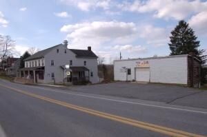
2096 New Danville Pike, Lancaster, PA 17603


NEARBY LISTINGS FOR SALE OR LEASE
Property Detail
2096 New Danville Pike
510-57719-0-0000
2096 NEW DANVILLE PIKE
Bartavern
Lancaster
X
Pennsylvania
42071C0502F
3
2024
0.30 AC
2025
Lancaster County
013901
Philadelphia
3,436 SF
Lancaster, PA
DEMOGRAPHICS near 2096 New Danville Pike
1 Mile
3 Mile
5 Mile
2024 Total Population
822
42,264
137,087
2029 Population
851
42,435
138,042
Pop Growth 2024-2029
+ 3.53%
+ 0.40%
+ 0.70%
Average Age
42
41
39
2024 Total Households
302
15,919
51,924
HH Growth 2024-2029
+ 3.31%
+ 0.17%
+ 0.61%
Median Household Inc
$76,591
$72,942
$68,893
Avg Household Size
2.70
2.40
2.40
2024 Avg HH Vehicles
2.00
2.00
2.00
Median Home Value
$266,666
$216,132
$221,453
Median Year Built
1979
1980
1961
Nearby Places
Map Layers
Map Styles
 Street
 Aerial
- Restaurants
- Banks
- Shops
- Fitness
- Groceries
PUBLIC TRANSPORTATION
COMMUTER RAIL
Lancaster (Keystone Service - Amtrak, Pennsylvanian - Amtrak)
DRIVE
WALK
Distance
Lancaster (Keystone Service - Amtrak, Pennsylvanian - Amtrak)
12 min
5.0 mi
AIRPORT
Harrisburg International
DRIVE
WALK
Distance
Harrisburg International
51 min
35.9 mi
Freight Ports
Port of Wilmington, RI
DRIVE
WALK
Distance
Port of Wilmington, RI
90 min
63.3 mi
SALE & LEASE HISTORY
LISTING DATE
SALE/LEASE

May 01, 2019
For Sale
Jun 25, 2018
For Sale
Jul 23, 2018
For Sale
Jul 12, 2018
For Sale
Dec 08, 2017
For Sale
Nearby Properties
Address
Land Use
TOTAL SIZE
Lot Size
Zoning
Address
Land Use
TOTAL SIZE
Lot Size
Zoning
1,906,102 SF
136.98 AC
R3
Address
Land Use
TOTAL SIZE
Lot Size
Zoning
2,008,418 SF
76.74 AC
Address
Land Use
TOTAL SIZE
Lot Size
Zoning
610,085 SF
57.70 AC
R1A
Address
Land Use
TOTAL SIZE
Lot Size
Zoning
307,696 SF
29 AC
R1
Address
Land Use
TOTAL SIZE
Lot Size
Zoning
288,628 SF
27.80 AC
R1A
Address
Land Use
TOTAL SIZE
Lot Size
Zoning
35,920 SF
35.68 AC
Address
Land Use
TOTAL SIZE
Lot Size
Zoning
216,206 SF
17.88 AC
Address
Land Use
TOTAL SIZE
Lot Size
Zoning
156,190 SF
26.53 AC
Address
Land Use
TOTAL SIZE
Lot Size
Zoning
98,798 SF
42.19 AC
Address
Land Use
TOTAL SIZE
Lot Size
Zoning
123,664 SF
1.60 AC
R1A
Address
Land Use
TOTAL SIZE
Lot Size
Zoning
166,685 SF
14.90 AC
R1A
Address
Land Use
TOTAL SIZE
Lot Size
Zoning
32.52 AC
R-2
Address
Land Use
TOTAL SIZE
Lot Size
Zoning
109,300 SF
18.63 AC
Address
Land Use
TOTAL SIZE
Lot Size
Zoning
172,568 SF
9.76 AC
R3
Address
Land Use
TOTAL SIZE
Lot Size
Zoning
281,887 SF
19.29 AC
R-3
Address
Land Use
TOTAL SIZE
Lot Size
Zoning
175,971 SF
20.40 AC
Address
Land Use
TOTAL SIZE
Lot Size
Zoning
146,813 SF
96.80 AC
A
Address
Land Use
TOTAL SIZE
Lot Size
Zoning
87,866 SF
5.10 AC
R-3
Address
Land Use
TOTAL SIZE
Lot Size
Zoning
101,204 SF
6 AC
R1A
Address
Land Use
TOTAL SIZE
Lot Size
Zoning
278,244 SF
29.90 AC
R-3
Address
Land Use
TOTAL SIZE
Lot Size
Zoning
95,432 SF
10.19 AC
Address
Land Use
TOTAL SIZE
Lot Size
Zoning
122,820 SF
11.80 AC
R-3
Address
Land Use
TOTAL SIZE
Lot Size
Zoning
102,768 SF
11.30 AC
Address
Land Use
TOTAL SIZE
Lot Size
Zoning
211,230 SF
14.80 AC
R-3
Address
Land Use
TOTAL SIZE
Lot Size
Zoning
59,403 SF
2.20 AC
R2
Address
Land Use
TOTAL SIZE
Lot Size
Zoning
159,022 SF
8.21 AC
R-3
Address
Land Use
TOTAL SIZE
Lot Size
Zoning
194,572 SF
18.70 AC
R3
Address
Land Use
TOTAL SIZE
Lot Size
Zoning
40,195 SF
37.15 AC
Address
Land Use
TOTAL SIZE
Lot Size
Zoning
94,000 SF
12 AC
R2
Address
Land Use
TOTAL SIZE
Lot Size
Zoning
131,604 SF
18.90 AC
R-3
The World's #1 Commercial Real Estate Marketplace
Connect with us
© 2026 CoStar Group
The information above has been obtained from sources believed reliable. While we do not doubt its accuracy we have not verified it and make no guarantee, warranty or representation about it. It is your responsibility to independently confirm its accuracy and completeness. Any projections, opinions, assumptions, or estimates used are for example only and do not represent the current or future performance of the property. The value of this transaction to you depends on tax and other factors which should be evaluated by your tax, financial, and legal advisors. You and your advisors should conduct a careful, independent investigation of the property to determine to your satisfaction the suitability of the property for your needs.