No Photo
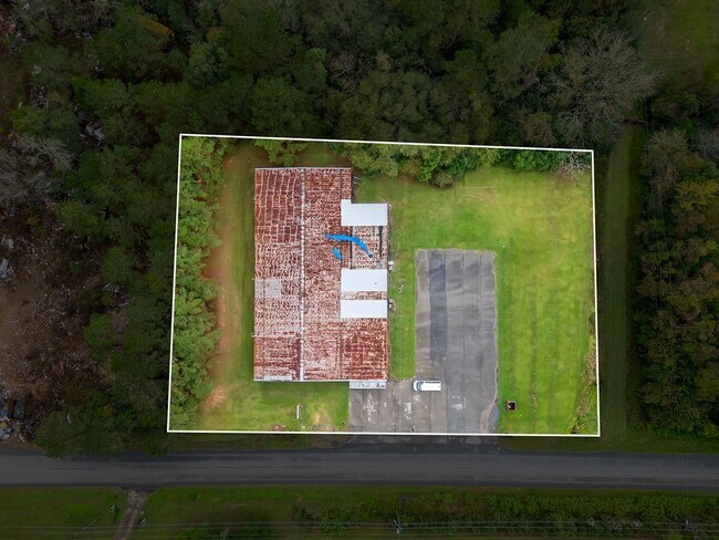
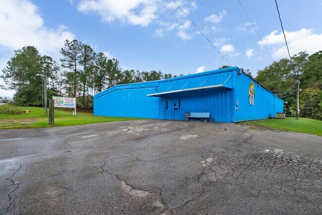
Property Record
21 20Th St Ne, Cairo, GA 39828

NEARBY LISTINGS FOR SALE OR LEASE
-
-
View all Cairo listings for sale on LoopNet.com
Property Detail
21 20Th St Ne
Commercialnec
Ff-Com: 200.00
X
Grady
13131C0170C
Georgia
2024
1.43 AC
2024
Albany/Southwest
950501
Other Market Areas
12,336 SF
C0370009
DEMOGRAPHICS near 21 20Th St Ne
1 Mile
3 Mile
5 Mile
2024 Total Population
2,660
11,810
15,683
2029 Population
2,624
11,739
15,576
Pop Growth 2024-2029
(1.35%)
(0.60%)
(0.68%)
Average Age
37
39
39
2024 Total Households
964
4,522
6,039
HH Growth 2024-2029
(1.45%)
(0.55%)
(0.65%)
Median Household Inc
$37,039
$40,726
$43,969
Avg Household Size
2.70
2.60
2.60
2024 Avg HH Vehicles
2.00
2.00
2.00
Median Home Value
$124,324
$133,738
$152,787
Median Year Built
1985
1983
1987
Nearby Places
Map Layers
Map Styles
 Street
 Aerial
- Restaurants
- Banks
- Shops
- Fitness
- Groceries
PUBLIC TRANSPORTATION
AIRPORT
Tallahassee International
DRIVE
WALK
Distance
Tallahassee International
63 min
42.2 mi
SALE & LEASE HISTORY
LISTING DATE
SALE/LEASE

Dec 30, 2024
For Sale
Nearby Properties
Address
Land Use
TOTAL SIZE
Lot Size
Zoning
Address
Land Use
TOTAL SIZE
Lot Size
Zoning
8,578 SF
752.69 AC
Address
Land Use
TOTAL SIZE
Lot Size
Zoning
158,850 SF
87.93 AC
Address
Land Use
TOTAL SIZE
Lot Size
Zoning
296,400 SF
18.48 AC
Address
Land Use
TOTAL SIZE
Lot Size
Zoning
98,632 SF
10.41 AC
Address
Land Use
TOTAL SIZE
Lot Size
Zoning
148,400 SF
12 AC
Address
Land Use
TOTAL SIZE
Lot Size
Zoning
103,016 SF
26.16 AC
Address
Land Use
TOTAL SIZE
Lot Size
Zoning
135,000 SF
13.54 AC
Address
Land Use
TOTAL SIZE
Lot Size
Zoning
6.91 AC
Address
Land Use
TOTAL SIZE
Lot Size
Zoning
114,580 SF
21.02 AC
Address
Land Use
TOTAL SIZE
Lot Size
Zoning
10,384 SF
9.99 AC
Address
Land Use
TOTAL SIZE
Lot Size
Zoning
64,053 SF
8.17 AC
Address
Land Use
TOTAL SIZE
Lot Size
Zoning
1,884 SF
5.99 AC
Address
Land Use
TOTAL SIZE
Lot Size
Zoning
59,275 SF
4.86 AC
Address
Land Use
TOTAL SIZE
Lot Size
Zoning
50,939 SF
5.62 AC
Address
Land Use
TOTAL SIZE
Lot Size
Zoning
960 SF
6.10 AC
Address
Land Use
TOTAL SIZE
Lot Size
Zoning
14,880 SF
6.23 AC
Address
Land Use
TOTAL SIZE
Lot Size
Zoning
46,272 SF
25.57 AC
Address
Land Use
TOTAL SIZE
Lot Size
Zoning
10,285 SF
165.53 AC
Address
Land Use
TOTAL SIZE
Lot Size
Zoning
2,760 SF
5.65 AC
Address
Land Use
TOTAL SIZE
Lot Size
Zoning
22,400 SF
4.57 AC
Address
Land Use
TOTAL SIZE
Lot Size
Zoning
0.47 AC
Address
Land Use
TOTAL SIZE
Lot Size
Zoning
11,000 SF
4.65 AC
Address
Land Use
TOTAL SIZE
Lot Size
Zoning
10,504 SF
1.98 AC
Address
Land Use
TOTAL SIZE
Lot Size
Zoning
35,064 SF
2.93 AC
Address
Land Use
TOTAL SIZE
Lot Size
Zoning
44,800 SF
4.66 AC
Address
Land Use
TOTAL SIZE
Lot Size
Zoning
3,200 SF
3 AC
Address
Land Use
TOTAL SIZE
Lot Size
Zoning
14,537 SF
2.29 AC
Address
Land Use
TOTAL SIZE
Lot Size
Zoning
9,919 SF
1.18 AC
Address
Land Use
TOTAL SIZE
Lot Size
Zoning
19,174 SF
2.77 AC
Address
Land Use
TOTAL SIZE
Lot Size
Zoning
600 SF
9.70 AC
The World's #1 Commercial Real Estate Marketplace
Connect with us
© 2026 CoStar Group
The information above has been obtained from sources believed reliable. While we do not doubt its accuracy we have not verified it and make no guarantee, warranty or representation about it. It is your responsibility to independently confirm its accuracy and completeness. Any projections, opinions, assumptions, or estimates used are for example only and do not represent the current or future performance of the property. The value of this transaction to you depends on tax and other factors which should be evaluated by your tax, financial, and legal advisors. You and your advisors should conduct a careful, independent investigation of the property to determine to your satisfaction the suitability of the property for your needs.