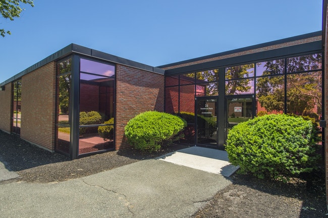
Property Record
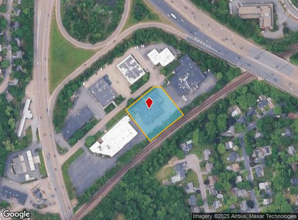
21 S West Park, Westwood, MA 02090
Current Lease Availabilities
NEARBY LISTINGS FOR SALE OR LEASE
Property Detail
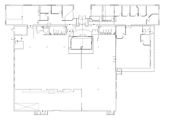
21 S West Park
WWOO-000017-000000-000066
Norfolk
Scientificpharmaceuticalmedicalresearchfacility
Massachusetts
AE
66
25021C0181F
1.34 AC
2025
Route 1 South
2025
Boston
412300
Boston-Cambridge-Newton, MA-NH
17,480 SF
DEMOGRAPHICS near 21 S West Park
1 Mile
3 Mile
5 Mile
2024 Total Population
7,296
65,121
191,249
2029 Population
7,298
64,077
186,593
Pop Growth 2024-2029
+ 0.03%
(1.60%)
(2.43%)
Average Age
42
42
42
2024 Total Households
2,691
25,544
71,837
HH Growth 2024-2029
+ 0.04%
(1.78%)
(2.79%)
Median Household Inc
$136,723
$108,553
$116,005
Avg Household Size
2.60
2.50
2.50
2024 Avg HH Vehicles
2.00
2.00
2.00
Median Home Value
$766,923
$672,523
$699,406
Median Year Built
1962
1958
1956
Nearby Places
Map Layers
Map Styles
 Street
 Aerial
- Restaurants
- Banks
- Shops
- Fitness
- Groceries
PUBLIC TRANSPORTATION
TRANSIT/SUBWAY
Islington (Franklin Line - Massachusetts Bay Transportation Authority Commuter Rail (Purple Line))
DRIVE
WALK
Distance
Islington (Franklin Line - Massachusetts Bay Transportation Authority Commuter Rail (Purple Line))
5 min
15 min
0.8 mi
Dedham Corporate Center (Franklin Line - Massachusetts Bay Transportation Authority Commuter Rail (Purple Line))
DRIVE
WALK
Distance
Dedham Corporate Center (Franklin Line - Massachusetts Bay Transportation Authority Commuter Rail (Purple Line))
3 min
20 min
1.0 mi
COMMUTER RAIL
Islington (Franklin Line - Massachusetts Bay Transportation Authority Commuter Rail (Purple Line))
DRIVE
WALK
Distance
Islington (Franklin Line - Massachusetts Bay Transportation Authority Commuter Rail (Purple Line))
5 min
20 min
1.1 mi
Dedham Corporate Center (Franklin Line - Massachusetts Bay Transportation Authority Commuter Rail (Purple Line))
DRIVE
WALK
Distance
Dedham Corporate Center (Franklin Line - Massachusetts Bay Transportation Authority Commuter Rail (Purple Line))
3 min
1.2 mi
AIRPORT
General Edward Lawrence Logan International
DRIVE
WALK
Distance
General Edward Lawrence Logan International
31 min
16.8 mi
Rhode Island Tf Green International
DRIVE
WALK
Distance
Rhode Island Tf Green International
62 min
43.7 mi
Freight Ports
Port of Boston
DRIVE
WALK
Distance
Port of Boston
29 min
15.1 mi
Nearby Properties
Address
Land Use
TOTAL SIZE
Lot Size
Zoning
Address
Land Use
TOTAL SIZE
Lot Size
Zoning
380,030 SF
24.87 AC
Address
Land Use
TOTAL SIZE
Lot Size
Zoning
355,941 SF
4.60 AC
A
Address
Land Use
TOTAL SIZE
Lot Size
Zoning
413,827 SF
9.49 AC
RDO
Address
Land Use
TOTAL SIZE
Lot Size
Zoning
11.66 AC
LM
Address
Land Use
TOTAL SIZE
Lot Size
Zoning
380,030 SF
24.87 AC
Address
Land Use
TOTAL SIZE
Lot Size
Zoning
45,836 SF
23.25 AC
Address
Land Use
TOTAL SIZE
Lot Size
Zoning
34.93 AC
LM
Address
Land Use
TOTAL SIZE
Lot Size
Zoning
221,803 SF
36.46 AC
Address
Land Use
TOTAL SIZE
Lot Size
Zoning
226,304 SF
2.89 AC
Address
Land Use
TOTAL SIZE
Lot Size
Zoning
18,451 SF
19.07 AC
Address
Land Use
TOTAL SIZE
Lot Size
Zoning
26,569 SF
45.93 AC
RC
Address
Land Use
TOTAL SIZE
Lot Size
Zoning
8.18 AC
B
Address
Land Use
TOTAL SIZE
Lot Size
Zoning
351,699 SF
27.36 AC
Address
Land Use
TOTAL SIZE
Lot Size
Zoning
5,349 SF
8.74 AC
Address
Land Use
TOTAL SIZE
Lot Size
Zoning
132,917 SF
24 AC
RE
Address
Land Use
TOTAL SIZE
Lot Size
Zoning
267,103 SF
20.23 AC
10
Address
Land Use
TOTAL SIZE
Lot Size
Zoning
180,022 SF
3.74 AC
Address
Land Use
TOTAL SIZE
Lot Size
Zoning
45.72 AC
LM
Address
Land Use
TOTAL SIZE
Lot Size
Zoning
15 AC
Address
Land Use
TOTAL SIZE
Lot Size
Zoning
141,322 SF
36.84 AC
Address
Land Use
TOTAL SIZE
Lot Size
Zoning
242,198 SF
53.28 AC
Address
Land Use
TOTAL SIZE
Lot Size
Zoning
81,796 SF
11.87 AC
Address
Land Use
TOTAL SIZE
Lot Size
Zoning
195,690 SF
14.98 AC
NV
Address
Land Use
TOTAL SIZE
Lot Size
Zoning
185,592 SF
37.21 AC
Address
Land Use
TOTAL SIZE
Lot Size
Zoning
294,771 SF
17.85 AC
Address
Land Use
TOTAL SIZE
Lot Size
Zoning
61,044 SF
5.60 AC
Address
Land Use
TOTAL SIZE
Lot Size
Zoning
62,043 SF
10.68 AC
6
Address
Land Use
TOTAL SIZE
Lot Size
Zoning
130,344 SF
8.18 AC
Address
Land Use
TOTAL SIZE
Lot Size
Zoning
18.01 AC
GB
Address
Land Use
TOTAL SIZE
Lot Size
Zoning
11.39 AC
B
The World's #1 Commercial Real Estate Marketplace
Connect with us
© 2025 CoStar Group
The information above has been obtained from sources believed reliable. While we do not doubt its accuracy we have not verified it and make no guarantee, warranty or representation about it. It is your responsibility to independently confirm its accuracy and completeness. Any projections, opinions, assumptions, or estimates used are for example only and do not represent the current or future performance of the property. The value of this transaction to you depends on tax and other factors which should be evaluated by your tax, financial, and legal advisors. You and your advisors should conduct a careful, independent investigation of the property to determine to your satisfaction the suitability of the property for your needs.