Property Record
21 3Rd Ave, Betterton, MD 21610

Property Detail
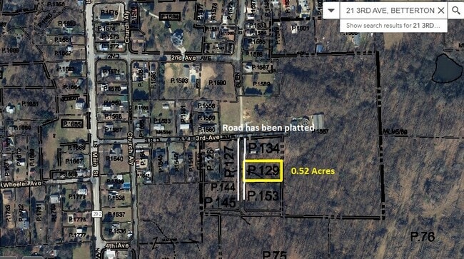
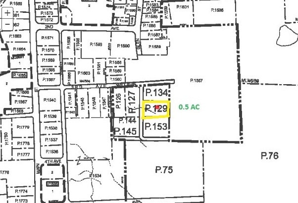
21 3Rd Ave
03-016919
LOT 90X225 21 THIRD AVE NR BETTERTON
Residentialacreage
KENT
R-2
Maryland
B and X Area of moderate flood hazard, usually the area between the limits of the 100-year and 500-year floods.
21
2025
0.53 AC
2025
Kent County
9502002116
Baltimore
NEARBY LISTINGS FOR SALE OR LEASE
-
-
View all Betterton listings for sale on LoopNet.com
DEMOGRAPHICS near 21 3Rd Ave
1 mile
3 mile
5 mile
2025 Total Population
398
1,371
2,637
2030 Population
408
1,438
2,759
Pop Growth 2025-2030
+ 2.51%
+ 4.89%
+ 4.63%
Average Age
50
48
48
2025 Total Households
184
589
1,133
HH Growth 2025-2030
+ 2.17%
+ 4.75%
+ 4.59%
Median Household Inc
$65,714
$96,874
$90,064
Avg Household Size
2.20
2.20
2.20
2025 Avg HH Vehicles
2.00
2.00
2.00
Median Home Value
$362,499
$357,070
$356,077
Median Year Built
1979
1979
1977
Nearby Places
Map Layers
Map Styles
 Street
 Aerial
Transit
 Traffic
 Biking
Places
Listings with unknown addresses are not visible on the map
- Restaurants
- Banks
- Shops
- Fitness
- Groceries
SALE & LEASE HISTORY
LISTING DATE
SALE/LEASE

May 06, 2024
For Sale
Nearby Properties
Address
Land Use
TOTAL SIZE
Lot Size
Zoning
Address
Land Use
TOTAL SIZE
Lot Size
Zoning
100 AC
SAR
Address
Land Use
TOTAL SIZE
Lot Size
Zoning
951 SF
4.79 AC
C-1
Address
Land Use
TOTAL SIZE
Lot Size
Zoning
672 SF
15.08 AC
RCDR2
Address
Land Use
TOTAL SIZE
Lot Size
Zoning
105.48 AC
OS
Address
Land Use
TOTAL SIZE
Lot Size
Zoning
19,829 SF
2.06 AC
B-1
Address
Land Use
TOTAL SIZE
Lot Size
Zoning
1,860 SF
191 AC
RCDAZ
Address
Land Use
TOTAL SIZE
Lot Size
Zoning
1,988 SF
72.33 AC
SAR
Address
Land Use
TOTAL SIZE
Lot Size
Zoning
5,800 SF
1.54 AC
Address
Land Use
TOTAL SIZE
Lot Size
Zoning
5.58 AC
RR
Address
Land Use
TOTAL SIZE
Lot Size
Zoning
5,384 SF
0.28 AC
R-3
Address
Land Use
TOTAL SIZE
Lot Size
Zoning
0.83 AC
RCD
Address
Land Use
TOTAL SIZE
Lot Size
Zoning
7,200 SF
0.34 AC
Address
Land Use
TOTAL SIZE
Lot Size
Zoning
330 SF
4 AC
Address
Land Use
TOTAL SIZE
Lot Size
Zoning
1,918 SF
0.51 AC
R-3
Address
Land Use
TOTAL SIZE
Lot Size
Zoning
6,826 SF
0.60 AC
R-3
Address
Land Use
TOTAL SIZE
Lot Size
Zoning
51.91 AC
SAR
Address
Land Use
TOTAL SIZE
Lot Size
Zoning
1.25 AC
RR
Address
Land Use
TOTAL SIZE
Lot Size
Zoning
1.22 AC
RR
Address
Land Use
TOTAL SIZE
Lot Size
Zoning
3,380 SF
0.68 AC
Address
Land Use
TOTAL SIZE
Lot Size
Zoning
1,288 SF
1.25 AC
V
Address
Land Use
TOTAL SIZE
Lot Size
Zoning
2.68 AC
RCD
Address
Land Use
TOTAL SIZE
Lot Size
Zoning
1,680 SF
0.37 AC
C-1
Address
Land Use
TOTAL SIZE
Lot Size
Zoning
0.82 AC
C-1
Address
Land Use
TOTAL SIZE
Lot Size
Zoning
1,628 SF
0.46 AC
RR
Address
Land Use
TOTAL SIZE
Lot Size
Zoning
2,580 SF
1.92 AC
Address
Land Use
TOTAL SIZE
Lot Size
Zoning
780 SF
0.30 AC
Address
Land Use
TOTAL SIZE
Lot Size
Zoning
6,560 SF
0.44 AC
V
Address
Land Use
TOTAL SIZE
Lot Size
Zoning
50 AC
RCD
Address
Land Use
TOTAL SIZE
Lot Size
Zoning
3,684 SF
0.25 AC
R-3
Address
Land Use
TOTAL SIZE
Lot Size
Zoning
2.37 AC
AZDRC
The World's #1 Commercial Real Estate Marketplace
Connect with us
© 2026 CoStar Group
The information above has been obtained from sources believed reliable. While we do not doubt its accuracy we have not verified it and make no guarantee, warranty or representation about it. It is your responsibility to independently confirm its accuracy and completeness. Any projections, opinions, assumptions, or estimates used are for example only and do not represent the current or future performance of the property. The value of this transaction to you depends on tax and other factors which should be evaluated by your tax, financial, and legal advisors. You and your advisors should conduct a careful, independent investigation of the property to determine to your satisfaction the suitability of the property for your needs.