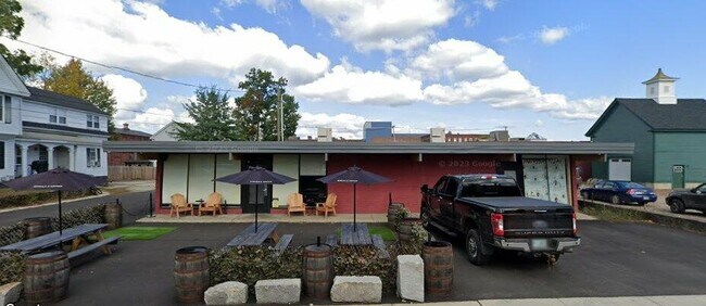
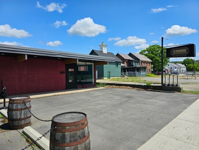
Property Record
21 Davis St, Keene, NH 03431

Property Detail
21 Davis St
584/ / 058/000 000/000
CHESHIRE
Commercialnec
New Hampshire
DT-C
58
B and X Area of moderate flood hazard, usually the area between the limits of the 100-year and 500-year floods.
0.18 AC
2024
Manchester/New Hampshire South Area
2024
Other Market Areas
971403
Keene, NH
4,003 SF
NEARBY LISTINGS FOR SALE OR LEASE
DEMOGRAPHICS near 21 Davis St
1 mile
3 mile
5 mile
2025 Total Population
11,025
23,029
29,527
2030 Population
11,185
23,391
29,953
Pop Growth 2025-2030
+ 1.45%
+ 1.57%
+ 1.44%
Average Age
38
42
43
2025 Total Households
4,633
9,797
12,514
HH Growth 2025-2030
+ 1.94%
+ 1.85%
+ 1.67%
Median Household Inc
$75,834
$83,491
$85,264
Avg Household Size
2.00
2.10
2.10
2025 Avg HH Vehicles
1.00
2.00
2.00
Median Home Value
$258,064
$278,385
$285,080
Median Year Built
1948
1960
1965
Nearby Places
Map Layers
Map Styles
 Street
 Aerial
Transit
 Traffic
 Biking
Places
Listings with unknown addresses are not visible on the map
- Restaurants
- Banks
- Shops
- Fitness
- Groceries
SALE & LEASE HISTORY
LISTING DATE
SALE/LEASE

Nov 10, 2023
For Lease
Jun 15, 2020
For Lease
Jun 08, 2020
For Lease
Jun 04, 2024
For Lease
Nearby Properties
Address
Land Use
TOTAL SIZE
Lot Size
Zoning
Address
Land Use
TOTAL SIZE
Lot Size
Zoning
Address
Land Use
TOTAL SIZE
Lot Size
Zoning
14.33 AC
HC
Address
Land Use
TOTAL SIZE
Lot Size
Zoning
52 AC
R
Address
Land Use
TOTAL SIZE
Lot Size
Zoning
25 AC
LD
Address
Land Use
TOTAL SIZE
Lot Size
Zoning
89,864 SF
14.77 AC
R
Address
Land Use
TOTAL SIZE
Lot Size
Zoning
13.20 AC
COM
Address
Land Use
TOTAL SIZE
Lot Size
Zoning
195,466 SF
18.66 AC
COM
Address
Land Use
TOTAL SIZE
Lot Size
Zoning
4.95 AC
DT-C
Address
Land Use
TOTAL SIZE
Lot Size
Zoning
122,326 SF
10 AC
COM
Address
Land Use
TOTAL SIZE
Lot Size
Zoning
13.43 AC
BGR
Address
Land Use
TOTAL SIZE
Lot Size
Zoning
14.97 AC
COM
Address
Land Use
TOTAL SIZE
Lot Size
Zoning
4.10 AC
BGR
Address
Land Use
TOTAL SIZE
Lot Size
Zoning
1,883 SF
99 AC
R
Address
Land Use
TOTAL SIZE
Lot Size
Zoning
6.49 AC
COM
Address
Land Use
TOTAL SIZE
Lot Size
Zoning
86,070 SF
HD
Address
Land Use
TOTAL SIZE
Lot Size
Zoning
13,950 SF
18.60 AC
CON
Address
Land Use
TOTAL SIZE
Lot Size
Zoning
54,874 SF
HD
Address
Land Use
TOTAL SIZE
Lot Size
Zoning
61,775 SF
HD
Address
Land Use
TOTAL SIZE
Lot Size
Zoning
84,905 SF
HD
Address
Land Use
TOTAL SIZE
Lot Size
Zoning
121,757 SF
5.20 AC
DT-G
Address
Land Use
TOTAL SIZE
Lot Size
Zoning
114,408 SF
11.86 AC
COM
Address
Land Use
TOTAL SIZE
Lot Size
Zoning
78,178 SF
HD
Address
Land Use
TOTAL SIZE
Lot Size
Zoning
10.12 AC
HD1
Address
Land Use
TOTAL SIZE
Lot Size
Zoning
85,136 SF
HD
Address
Land Use
TOTAL SIZE
Lot Size
Zoning
65,462 SF
1.01 AC
HD
Address
Land Use
TOTAL SIZE
Lot Size
Zoning
142,790 SF
50 AC
IP
Address
Land Use
TOTAL SIZE
Lot Size
Zoning
78,042 SF
9.18 AC
HC
Address
Land Use
TOTAL SIZE
Lot Size
Zoning
97,804 SF
2.51 AC
BUSINE
Address
Land Use
TOTAL SIZE
Lot Size
Zoning
91,428 SF
16.43 AC
COMM/I
Address
Land Use
TOTAL SIZE
Lot Size
Zoning
The World's #1 Commercial Real Estate Marketplace
Connect with us
© 2026 CoStar Group
The information above has been obtained from sources believed reliable. While we do not doubt its accuracy we have not verified it and make no guarantee, warranty or representation about it. It is your responsibility to independently confirm its accuracy and completeness. Any projections, opinions, assumptions, or estimates used are for example only and do not represent the current or future performance of the property. The value of this transaction to you depends on tax and other factors which should be evaluated by your tax, financial, and legal advisors. You and your advisors should conduct a careful, independent investigation of the property to determine to your satisfaction the suitability of the property for your needs.