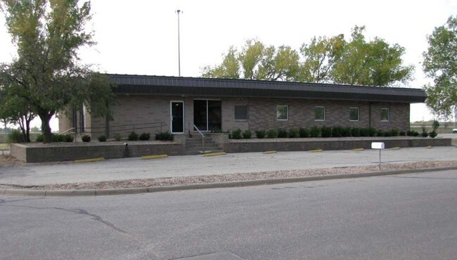
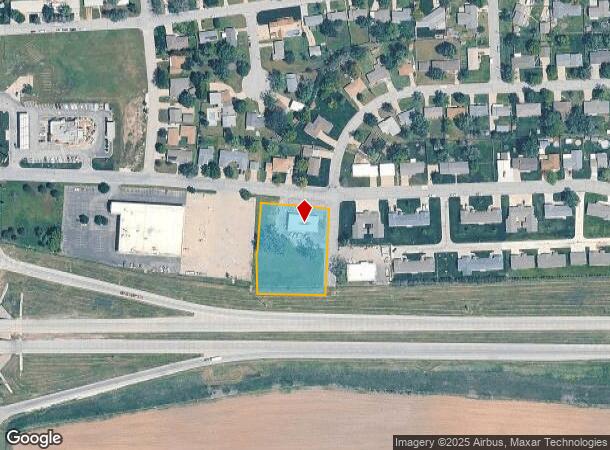
Property Record
21 Des Moines Ave, South Hutchinson, KS 67505
NEARBY LISTINGS FOR SALE OR LEASE
Property Detail
21 Des Moines Ave
Hutchinson, KS
William's
127-25-0-30-20-001.00
WILLIAM'S, S25, T23, R06W, LOTS 5-10 BLK J EXC HWY R/W
Officebuilding
Reno
X
Kansas
20155C0293G
5,10
2024
1.33 AC
2024
Kansas Area
001300
Other Market Areas
3,600 SF
DEMOGRAPHICS near 21 Des Moines Ave
1 Mile
3 Mile
5 Mile
2024 Total Population
1,229
8,392
33,103
2029 Population
1,217
8,432
33,095
Pop Growth 2024-2029
(0.98%)
+ 0.48%
(0.02%)
Average Age
44
41
41
2024 Total Households
567
3,712
14,284
HH Growth 2024-2029
(0.88%)
+ 0.43%
(0.06%)
Median Household Inc
$39,721
$38,322
$47,829
Avg Household Size
2.10
2.10
2.20
2024 Avg HH Vehicles
2.00
2.00
2.00
Median Home Value
$112,952
$77,426
$87,104
Median Year Built
1972
1953
1955
Nearby Places
Map Layers
Map Styles
 Street
 Aerial
- Restaurants
- Banks
- Shops
- Fitness
- Groceries
PUBLIC TRANSPORTATION
COMMUTER RAIL
Hutchinson Amtrak Station (Southwest Chief - Amtrak)
DRIVE
WALK
Distance
Hutchinson Amtrak Station (Southwest Chief - Amtrak)
6 min
3.3 mi
Freight Ports
Tulsa Port Of Catoosa
DRIVE
WALK
Distance
Tulsa Port Of Catoosa
257 min
239.1 mi
Nearby Properties
Address
Land Use
TOTAL SIZE
Lot Size
Zoning
Address
Land Use
TOTAL SIZE
Lot Size
Zoning
94,825 SF
10 AC
Address
Land Use
TOTAL SIZE
Lot Size
Zoning
89,458 SF
1.88 AC
P
Address
Land Use
TOTAL SIZE
Lot Size
Zoning
59.65 AC
P
Address
Land Use
TOTAL SIZE
Lot Size
Zoning
1,960 SF
15.96 AC
Address
Land Use
TOTAL SIZE
Lot Size
Zoning
29,431 SF
1.50 AC
C5
Address
Land Use
TOTAL SIZE
Lot Size
Zoning
36,000 SF
19.49 AC
Address
Land Use
TOTAL SIZE
Lot Size
Zoning
1,136 SF
4.68 AC
Address
Land Use
TOTAL SIZE
Lot Size
Zoning
101,932 SF
1.50 AC
P
Address
Land Use
TOTAL SIZE
Lot Size
Zoning
1,848 SF
12.35 AC
Address
Land Use
TOTAL SIZE
Lot Size
Zoning
151.45 AC
Address
Land Use
TOTAL SIZE
Lot Size
Zoning
16,288 SF
0.38 AC
C5
Address
Land Use
TOTAL SIZE
Lot Size
Zoning
11,216 SF
1.88 AC
P
Address
Land Use
TOTAL SIZE
Lot Size
Zoning
1,752 SF
103.49 AC
Address
Land Use
TOTAL SIZE
Lot Size
Zoning
468 SF
34.12 AC
Address
Land Use
TOTAL SIZE
Lot Size
Zoning
4,000 SF
15.02 AC
I2
Address
Land Use
TOTAL SIZE
Lot Size
Zoning
154.95 AC
Address
Land Use
TOTAL SIZE
Lot Size
Zoning
58,907 SF
6.63 AC
Address
Land Use
TOTAL SIZE
Lot Size
Zoning
9,600 SF
17.98 AC
Address
Land Use
TOTAL SIZE
Lot Size
Zoning
2,035 SF
43.77 AC
Address
Land Use
TOTAL SIZE
Lot Size
Zoning
39,856 SF
12.80 AC
PI
Address
Land Use
TOTAL SIZE
Lot Size
Zoning
23,424 SF
0.80 AC
C5
Address
Land Use
TOTAL SIZE
Lot Size
Zoning
44,204 SF
1.46 AC
C5
Address
Land Use
TOTAL SIZE
Lot Size
Zoning
35,372 SF
0.83 AC
PI
Address
Land Use
TOTAL SIZE
Lot Size
Zoning
7,326 SF
0.80 AC
Address
Land Use
TOTAL SIZE
Lot Size
Zoning
7,326 SF
0.74 AC
Address
Land Use
TOTAL SIZE
Lot Size
Zoning
33,622 SF
2.83 AC
P
Address
Land Use
TOTAL SIZE
Lot Size
Zoning
180 SF
73.59 AC
PI
Address
Land Use
TOTAL SIZE
Lot Size
Zoning
15,214 SF
2.83 AC
P
Address
Land Use
TOTAL SIZE
Lot Size
Zoning
35,153 SF
3.22 AC
Address
Land Use
TOTAL SIZE
Lot Size
Zoning
2,615 SF
9.07 AC
The World's #1 Commercial Real Estate Marketplace
Connect with us
© 2025 CoStar Group
The information above has been obtained from sources believed reliable. While we do not doubt its accuracy we have not verified it and make no guarantee, warranty or representation about it. It is your responsibility to independently confirm its accuracy and completeness. Any projections, opinions, assumptions, or estimates used are for example only and do not represent the current or future performance of the property. The value of this transaction to you depends on tax and other factors which should be evaluated by your tax, financial, and legal advisors. You and your advisors should conduct a careful, independent investigation of the property to determine to your satisfaction the suitability of the property for your needs.