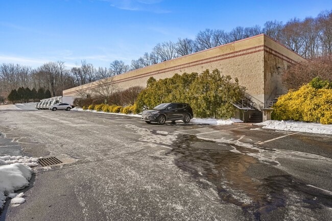
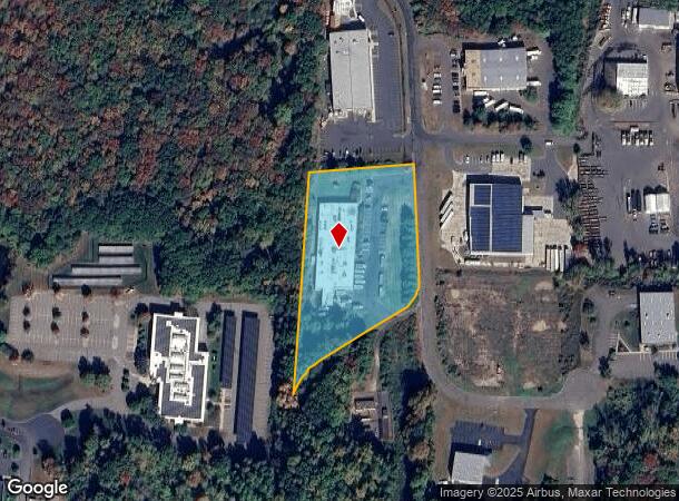
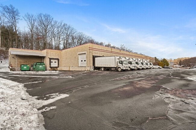
Property Record
21 Diana Ct, Cheshire, CT 06410
Current Lease Availabilities
NEARBY LISTINGS FOR SALE OR LEASE
Property Detail
21 Diana Ct
Manufacturinglight
New Haven
X
Connecticut
09003C0592G
3.30 AC
2025
Cheshire
2025
Westchester/So Connecticut
343101
New Haven-Milford, CT
20,211 SF
CHES-000011-000030
DEMOGRAPHICS near 21 Diana Ct
1 Mile
3 Mile
5 Mile
2024 Total Population
1,779
30,135
109,623
2029 Population
1,786
29,964
109,120
Pop Growth 2024-2029
+ 0.39%
(0.57%)
(0.46%)
Average Age
41
43
41
2024 Total Households
289
10,827
42,159
HH Growth 2024-2029
(0.69%)
(0.73%)
(0.51%)
Median Household Inc
$154,375
$116,609
$85,198
Avg Household Size
2.60
2.60
2.50
2024 Avg HH Vehicles
2.00
2.00
2.00
Median Home Value
$438,513
$333,494
$297,273
Median Year Built
1981
1969
1966
Nearby Places
Map Layers
Map Styles
 Street
 Aerial
- Restaurants
- Banks
- Shops
- Fitness
- Groceries
PUBLIC TRANSPORTATION
COMMUTER RAIL
DRIVE
WALK
Distance
9 min
6.2 mi
DRIVE
WALK
Distance
10 min
6.3 mi
AIRPORT
Tweed/New Haven
DRIVE
WALK
Distance
Tweed/New Haven
36 min
23.2 mi
Bradley International
DRIVE
WALK
Distance
Bradley International
62 min
36.7 mi
Nearby Properties
Address
Land Use
TOTAL SIZE
Lot Size
Zoning
Address
Land Use
TOTAL SIZE
Lot Size
Zoning
1,664 SF
166.95 AC
I-2
Address
Land Use
TOTAL SIZE
Lot Size
Zoning
2,400 SF
38.29 AC
M-3
Address
Land Use
TOTAL SIZE
Lot Size
Zoning
313,293 SF
53.21 AC
I-1
Address
Land Use
TOTAL SIZE
Lot Size
Zoning
30.10 AC
ICSDD
Address
Land Use
TOTAL SIZE
Lot Size
Zoning
5,600 SF
59 AC
R-40
Address
Land Use
TOTAL SIZE
Lot Size
Zoning
34.10 AC
C-3
Address
Land Use
TOTAL SIZE
Lot Size
Zoning
531,397 SF
82.40 AC
I-2
Address
Land Use
TOTAL SIZE
Lot Size
Zoning
245,122 SF
32.60 AC
R-1
Address
Land Use
TOTAL SIZE
Lot Size
Zoning
24.80 AC
R-20A
Address
Land Use
TOTAL SIZE
Lot Size
Zoning
243,820 SF
39.42 AC
I-2
Address
Land Use
TOTAL SIZE
Lot Size
Zoning
116,196 SF
9.45 AC
R-20
Address
Land Use
TOTAL SIZE
Lot Size
Zoning
73,961 SF
27.36 AC
I-2
Address
Land Use
TOTAL SIZE
Lot Size
Zoning
86,019 SF
7.51 AC
B
Address
Land Use
TOTAL SIZE
Lot Size
Zoning
130,912 SF
11 AC
R-12
Address
Land Use
TOTAL SIZE
Lot Size
Zoning
14,307 SF
13.39 AC
R-20/2
Address
Land Use
TOTAL SIZE
Lot Size
Zoning
281,623 SF
39.24 AC
I-2
Address
Land Use
TOTAL SIZE
Lot Size
Zoning
172,891 SF
75 AC
I-2
Address
Land Use
TOTAL SIZE
Lot Size
Zoning
241,500 SF
16.93 AC
I-1
Address
Land Use
TOTAL SIZE
Lot Size
Zoning
154,702 SF
33.86 AC
I-2
Address
Land Use
TOTAL SIZE
Lot Size
Zoning
14,200 SF
19.20 AC
I-2
Address
Land Use
TOTAL SIZE
Lot Size
Zoning
48,960 SF
5.94 AC
R-20
Address
Land Use
TOTAL SIZE
Lot Size
Zoning
57,572 SF
9.87 AC
I-1
Address
Land Use
TOTAL SIZE
Lot Size
Zoning
143,115 SF
13.14 AC
I-2
Address
Land Use
TOTAL SIZE
Lot Size
Zoning
72,224 SF
9.09 AC
I-2
Address
Land Use
TOTAL SIZE
Lot Size
Zoning
118,206 SF
13.20 AC
I-2
Address
Land Use
TOTAL SIZE
Lot Size
Zoning
25,200 SF
5.80 AC
I-2
Address
Land Use
TOTAL SIZE
Lot Size
Zoning
23,590 SF
12.30 AC
R-20
Address
Land Use
TOTAL SIZE
Lot Size
Zoning
26.22 AC
R-20/2
Address
Land Use
TOTAL SIZE
Lot Size
Zoning
87,980 SF
14.43 AC
R-20/2
Address
Land Use
TOTAL SIZE
Lot Size
Zoning
45,526 SF
28.90 AC
R-20/2
The World's #1 Commercial Real Estate Marketplace
Connect with us
© 2025 CoStar Group
The information above has been obtained from sources believed reliable. While we do not doubt its accuracy we have not verified it and make no guarantee, warranty or representation about it. It is your responsibility to independently confirm its accuracy and completeness. Any projections, opinions, assumptions, or estimates used are for example only and do not represent the current or future performance of the property. The value of this transaction to you depends on tax and other factors which should be evaluated by your tax, financial, and legal advisors. You and your advisors should conduct a careful, independent investigation of the property to determine to your satisfaction the suitability of the property for your needs.