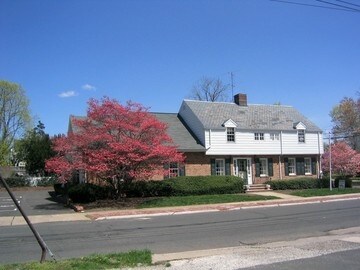
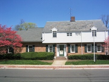
Property Record
21 E 2Nd St, Bound Brook, NJ 08805

Property Detail
21 E 2Nd St
04-00032-0000-00008
ADDITIONAL LOTS: 9/FACILITY NAME: CHURCH OFFICES
Vacantlandnec
Somerset
R4
New Jersey
B and X Area of moderate flood hazard, usually the area between the limits of the 100-year and 500-year floods.
8
0
0.23 AC
2025
Route 287 West
051100
Northern New Jersey
5,054 SF
Lakewood-New Brunswick, NJ
NEARBY LISTINGS FOR SALE OR LEASE
DEMOGRAPHICS near 21 E 2Nd St
1 mile
3 mile
5 mile
2024 Total Population
16,550
65,682
185,118
2029 Population
16,998
68,100
192,548
Pop Growth 2024-2029
+ 2.71%
+ 3.68%
+ 4.01%
Average Age
39
41
41
2024 Total Households
5,936
23,872
66,759
HH Growth 2024-2029
+ 3.00%
+ 3.89%
+ 4.26%
Median Household Inc
$90,899
$122,646
$122,030
Avg Household Size
2.70
2.70
2.70
2024 Avg HH Vehicles
2.00
2.00
2.00
Median Home Value
$407,887
$462,527
$472,927
Median Year Built
1958
1970
1970
Nearby Places
Map Layers
Map Styles
 Street
 Aerial
Transit
 Traffic
 Biking
Places
Listings with unknown addresses are not visible on the map
- Restaurants
- Banks
- Shops
- Fitness
- Groceries
PUBLIC TRANSPORTATION
TRANSIT/SUBWAY
Bound Brook (Raritan Valley Line - NJ Transit Commuter Rail (NJ Transit))
Drive
Walk
Distance
Bound Brook (Raritan Valley Line - NJ Transit Commuter Rail (NJ Transit))
1 min
5 min
0.3 mi
COMMUTER RAIL
Bound Brook (Raritan Valley Line - NJ Transit Commuter Rail (NJ Transit))
Drive
Walk
Distance
Bound Brook (Raritan Valley Line - NJ Transit Commuter Rail (NJ Transit))
1 min
5 min
0.3 mi
Bridgewater (Raritan Valley Line - NJ Transit Commuter Rail (NJ Transit))
Drive
Walk
Distance
Bridgewater (Raritan Valley Line - NJ Transit Commuter Rail (NJ Transit))
4 min
1.2 mi
AIRPORT
Newark Liberty International
Drive
Walk
Distance
Newark Liberty International
39 min
27.3 mi
Trenton Mercer
Drive
Walk
Distance
Trenton Mercer
54 min
34.4 mi
Freight Ports
New York Container Terminal
Drive
Walk
Distance
New York Container Terminal
37 min
28.0 mi
Nearby Properties
Address
Land Use
TOTAL SIZE
Lot Size
Zoning
Address
Land Use
TOTAL SIZE
Lot Size
Zoning
31.49 AC
LI5
Address
Land Use
TOTAL SIZE
Lot Size
Zoning
6,625 SF
22.51 AC
B-I
Address
Land Use
TOTAL SIZE
Lot Size
Zoning
70.22 AC
B-I
Address
Land Use
TOTAL SIZE
Lot Size
Zoning
17.01 AC
B-I
Address
Land Use
TOTAL SIZE
Lot Size
Zoning
19.46 AC
B-I
Address
Land Use
TOTAL SIZE
Lot Size
Zoning
39.10 AC
C3
Address
Land Use
TOTAL SIZE
Lot Size
Zoning
31.50 AC
B-I
Address
Land Use
TOTAL SIZE
Lot Size
Zoning
22.36 AC
PAC
Address
Land Use
TOTAL SIZE
Lot Size
Zoning
2,450 SF
26.84 AC
B-I
Address
Land Use
TOTAL SIZE
Lot Size
Zoning
22.75 AC
LC
Address
Land Use
TOTAL SIZE
Lot Size
Zoning
153 AC
Address
Land Use
TOTAL SIZE
Lot Size
Zoning
310,200 SF
26.23 AC
B-I
Address
Land Use
TOTAL SIZE
Lot Size
Zoning
32.92 AC
B-I
Address
Land Use
TOTAL SIZE
Lot Size
Zoning
Address
Land Use
TOTAL SIZE
Lot Size
Zoning
Address
Land Use
TOTAL SIZE
Lot Size
Zoning
163,776 SF
44.53 AC
LI5
Address
Land Use
TOTAL SIZE
Lot Size
Zoning
24.34 AC
IND
Address
Land Use
TOTAL SIZE
Lot Size
Zoning
82.79 AC
M2
Address
Land Use
TOTAL SIZE
Lot Size
Zoning
2,488 SF
16.46 AC
PAC
Address
Land Use
TOTAL SIZE
Lot Size
Zoning
26.53 AC
B-I
Address
Land Use
TOTAL SIZE
Lot Size
Zoning
230,022 SF
15.48 AC
LI5
Address
Land Use
TOTAL SIZE
Lot Size
Zoning
4.05 AC
Address
Land Use
TOTAL SIZE
Lot Size
Zoning
13.38 AC
B2
Address
Land Use
TOTAL SIZE
Lot Size
Zoning
277,731 SF
17.91 AC
LI5
Address
Land Use
TOTAL SIZE
Lot Size
Zoning
309,212 SF
20.98 AC
B-I
Address
Land Use
TOTAL SIZE
Lot Size
Zoning
224,360 SF
17.65 AC
B-I
Address
Land Use
TOTAL SIZE
Lot Size
Zoning
237,360 SF
14.48 AC
B-I
Address
Land Use
TOTAL SIZE
Lot Size
Zoning
19.90 AC
IND
Address
Land Use
TOTAL SIZE
Lot Size
Zoning
19.63 AC
B-I
Address
Land Use
TOTAL SIZE
Lot Size
Zoning
237,580 SF
22 AC
B-I
The World's #1 Commercial Real Estate Marketplace
Connect with us
© 2026 CoStar Group
The information above has been obtained from sources believed reliable. While we do not doubt its accuracy we have not verified it and make no guarantee, warranty or representation about it. It is your responsibility to independently confirm its accuracy and completeness. Any projections, opinions, assumptions, or estimates used are for example only and do not represent the current or future performance of the property. The value of this transaction to you depends on tax and other factors which should be evaluated by your tax, financial, and legal advisors. You and your advisors should conduct a careful, independent investigation of the property to determine to your satisfaction the suitability of the property for your needs.