Property Record
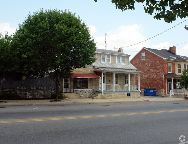
21 E Potomac St, Williamsport, MD 21795


NEARBY LISTINGS FOR SALE OR LEASE
-
-
View all Williamsport listings for sale on LoopNet.com
Property Detail
21 E Potomac St
Hagerstown-Martinsburg, MD-WV
General Plan Williamsport
02-006081
LOT 198 66X196 21 E POTOMAC ST
Storebuilding
Washington
X
Maryland
24043C0277D
198
2024
0.30 AC
2025
Washington County
010802
Washington, DC
3,207 SF
DEMOGRAPHICS near 21 E Potomac St
1 mile
3 mile
5 mile
2024 Total Population
2,954
15,591
38,015
2029 Population
2,980
16,311
39,790
Pop Growth 2024-2029
+ 0.88%
+ 4.62%
+ 4.67%
Average Age
45
43
41
2024 Total Households
1,283
6,239
14,739
HH Growth 2024-2029
+ 0.94%
+ 4.87%
+ 4.85%
Median Household Inc
$55,975
$70,155
$70,977
Avg Household Size
2.20
2.40
2.50
2024 Avg HH Vehicles
2.00
2.00
2.00
Median Home Value
$179,047
$228,809
$225,816
Median Year Built
1959
1982
1980
Nearby Places
Map Layers
Map Styles
 Street
 Aerial
Transit
 Traffic
 Biking
Places
Listings with unknown addresses are not visible on the map
- Restaurants
- Banks
- Shops
- Fitness
- Groceries
PUBLIC TRANSPORTATION
AIRPORT
Hagerstown Regional/Richard A Henson Field
Drive
Walk
Distance
Hagerstown Regional/Richard A Henson Field
15 min
10.3 mi
Freight Ports
Port of Baltimore
Drive
Walk
Distance
Port of Baltimore
94 min
79.6 mi
Nearby Properties
Address
Land Use
TOTAL SIZE
Lot Size
Zoning
Address
Land Use
TOTAL SIZE
Lot Size
Zoning
825,620 SF
53.74 AC
IG
Address
Land Use
TOTAL SIZE
Lot Size
Zoning
157,680 SF
69.83 AC
HI
Address
Land Use
TOTAL SIZE
Lot Size
Zoning
153,846 SF
110.85 AC
U
Address
Land Use
TOTAL SIZE
Lot Size
Zoning
1,021,162 SF
117.63 AC
HI
Address
Land Use
TOTAL SIZE
Lot Size
Zoning
824,298 SF
70.25 AC
HI
Address
Land Use
TOTAL SIZE
Lot Size
Zoning
294,240 SF
43.79 AC
HI
Address
Land Use
TOTAL SIZE
Lot Size
Zoning
161,172 SF
19.70 AC
HI
Address
Land Use
TOTAL SIZE
Lot Size
Zoning
506,003 SF
40 AC
HI
Address
Land Use
TOTAL SIZE
Lot Size
Zoning
486,861 SF
35.40 AC
HI
Address
Land Use
TOTAL SIZE
Lot Size
Zoning
231,293 SF
16.93 AC
PI
Address
Land Use
TOTAL SIZE
Lot Size
Zoning
88,042 SF
9.98 AC
RT
Address
Land Use
TOTAL SIZE
Lot Size
Zoning
36,000 SF
23.49 AC
HI
Address
Land Use
TOTAL SIZE
Lot Size
Zoning
9,918 SF
17 AC
IG
Address
Land Use
TOTAL SIZE
Lot Size
Zoning
2,324 SF
6 AC
TR
Address
Land Use
TOTAL SIZE
Lot Size
Zoning
924 SF
67.86 AC
RU
Address
Land Use
TOTAL SIZE
Lot Size
Zoning
58,065 SF
15.42 AC
BG
Address
Land Use
TOTAL SIZE
Lot Size
Zoning
7,943 SF
26.33 AC
HI
Address
Land Use
TOTAL SIZE
Lot Size
Zoning
2,723 SF
89.57 AC
RB-E
Address
Land Use
TOTAL SIZE
Lot Size
Zoning
32,788 SF
22.20 AC
PI
Address
Land Use
TOTAL SIZE
Lot Size
Zoning
120 SF
8.97 AC
RM
Address
Land Use
TOTAL SIZE
Lot Size
Zoning
247,962 SF
14.66 AC
PI
Address
Land Use
TOTAL SIZE
Lot Size
Zoning
327,100 SF
41.81 AC
PI
Address
Land Use
TOTAL SIZE
Lot Size
Zoning
12,144 SF
8.30 AC
U
Address
Land Use
TOTAL SIZE
Lot Size
Zoning
47,237 SF
9.58 AC
PB
Address
Land Use
TOTAL SIZE
Lot Size
Zoning
104,710 SF
8.81 AC
BG
Address
Land Use
TOTAL SIZE
Lot Size
Zoning
220,800 SF
20.54 AC
IG
Address
Land Use
TOTAL SIZE
Lot Size
Zoning
61,205 SF
9.13 AC
HI
Address
Land Use
TOTAL SIZE
Lot Size
Zoning
1,512 SF
44.61 AC
RU
Address
Land Use
TOTAL SIZE
Lot Size
Zoning
85,429 SF
15.37 AC
PI
Address
Land Use
TOTAL SIZE
Lot Size
Zoning
88,407 SF
9.82 AC
BG
The World's #1 Commercial Real Estate Marketplace
Connect with us
© 2026 CoStar Group
The information above has been obtained from sources believed reliable. While we do not doubt its accuracy we have not verified it and make no guarantee, warranty or representation about it. It is your responsibility to independently confirm its accuracy and completeness. Any projections, opinions, assumptions, or estimates used are for example only and do not represent the current or future performance of the property. The value of this transaction to you depends on tax and other factors which should be evaluated by your tax, financial, and legal advisors. You and your advisors should conduct a careful, independent investigation of the property to determine to your satisfaction the suitability of the property for your needs.