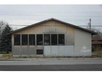
Property Record
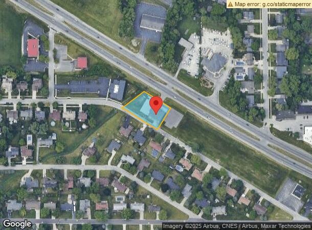
21 E Us Highway 30, Schererville, IN 46375
Current Lease Availabilities
NEARBY LISTINGS FOR SALE OR LEASE
Property Detail
21 E Us Highway 30
Chicago-Naperville-Elgin, IL-IN
Ja Addition
45-11-15-303-012.000-036
JA ADDITION LOT 1
Officebuilding
Lake
X
Indiana
18089C0227E
1
2024
0.66 AC
2025
Indiana
042704
Chicago
6,504 SF
DEMOGRAPHICS near 21 E Us Highway 30
1 Mile
3 Mile
5 Mile
2024 Total Population
7,311
44,251
135,306
2029 Population
7,244
43,884
134,845
Pop Growth 2024-2029
(0.92%)
(0.83%)
(0.34%)
Average Age
45
43
42
2024 Total Households
3,153
17,595
53,364
HH Growth 2024-2029
(0.92%)
(0.88%)
(0.41%)
Median Household Inc
$80,912
$90,854
$85,800
Avg Household Size
2.30
2.50
2.50
2024 Avg HH Vehicles
2.00
2.00
2.00
Median Home Value
$251,707
$275,542
$254,158
Median Year Built
1977
1989
1981
Nearby Places
Map Layers
Map Styles
 Street
 Aerial
- Restaurants
- Banks
- Shops
- Fitness
- Groceries
PUBLIC TRANSPORTATION
COMMUTER RAIL
DRIVE
WALK
Distance
11 min
5.3 mi
AIRPORT
Chicago Midway International
DRIVE
WALK
Distance
Chicago Midway International
53 min
33.5 mi
Nearby Properties
Address
Land Use
TOTAL SIZE
Lot Size
Zoning
Address
Land Use
TOTAL SIZE
Lot Size
Zoning
206,854 SF
8.38 AC
Address
Land Use
TOTAL SIZE
Lot Size
Zoning
168,766 SF
19.16 AC
Address
Land Use
TOTAL SIZE
Lot Size
Zoning
143,274 SF
17.90 AC
1116
Address
Land Use
TOTAL SIZE
Lot Size
Zoning
130,558 SF
9.89 AC
R33
Address
Land Use
TOTAL SIZE
Lot Size
Zoning
190,457 SF
10.63 AC
Address
Land Use
TOTAL SIZE
Lot Size
Zoning
100,659 SF
3.89 AC
Address
Land Use
TOTAL SIZE
Lot Size
Zoning
132,147 SF
44.38 AC
R33
Address
Land Use
TOTAL SIZE
Lot Size
Zoning
246,302 SF
13.08 AC
Address
Land Use
TOTAL SIZE
Lot Size
Zoning
300,509 SF
84.07 AC
Address
Land Use
TOTAL SIZE
Lot Size
Zoning
62,026 SF
9.70 AC
Address
Land Use
TOTAL SIZE
Lot Size
Zoning
64,971 SF
6.98 AC
Address
Land Use
TOTAL SIZE
Lot Size
Zoning
176,859 SF
12.01 AC
R33
Address
Land Use
TOTAL SIZE
Lot Size
Zoning
45,397 SF
14.48 AC
Address
Land Use
TOTAL SIZE
Lot Size
Zoning
60,992 SF
11.38 AC
R33
Address
Land Use
TOTAL SIZE
Lot Size
Zoning
34,116 SF
73.40 AC
Address
Land Use
TOTAL SIZE
Lot Size
Zoning
39,705 SF
23.63 AC
R33
Address
Land Use
TOTAL SIZE
Lot Size
Zoning
158,292 SF
8.20 AC
Address
Land Use
TOTAL SIZE
Lot Size
Zoning
129,320 SF
3.96 AC
Address
Land Use
TOTAL SIZE
Lot Size
Zoning
134,080 SF
10 AC
Address
Land Use
TOTAL SIZE
Lot Size
Zoning
53,024 SF
43.30 AC
Address
Land Use
TOTAL SIZE
Lot Size
Zoning
87,264 SF
7.74 AC
Address
Land Use
TOTAL SIZE
Lot Size
Zoning
78,221 SF
6.37 AC
Address
Land Use
TOTAL SIZE
Lot Size
Zoning
119,758 SF
3.80 AC
Address
Land Use
TOTAL SIZE
Lot Size
Zoning
68.50 AC
Address
Land Use
TOTAL SIZE
Lot Size
Zoning
156,258 SF
4.80 AC
Address
Land Use
TOTAL SIZE
Lot Size
Zoning
39,814 SF
2.49 AC
Address
Land Use
TOTAL SIZE
Lot Size
Zoning
52,896 SF
4.06 AC
R33
Address
Land Use
TOTAL SIZE
Lot Size
Zoning
123,693 SF
12.45 AC
Address
Land Use
TOTAL SIZE
Lot Size
Zoning
148,851 SF
20.81 AC
Address
Land Use
TOTAL SIZE
Lot Size
Zoning
35,471 SF
6.90 AC
R33
The World's #1 Commercial Real Estate Marketplace
Connect with us
© 2026 CoStar Group
The information above has been obtained from sources believed reliable. While we do not doubt its accuracy we have not verified it and make no guarantee, warranty or representation about it. It is your responsibility to independently confirm its accuracy and completeness. Any projections, opinions, assumptions, or estimates used are for example only and do not represent the current or future performance of the property. The value of this transaction to you depends on tax and other factors which should be evaluated by your tax, financial, and legal advisors. You and your advisors should conduct a careful, independent investigation of the property to determine to your satisfaction the suitability of the property for your needs.