Property Record
21 Grist Mill & Hwy, Uhland, TX 78640


Save to a Folder
{{folder.Name}}
{{folder.ListingIds.length}} Properties
{{folder.ListingIds.length}} Property
Create a New Folder
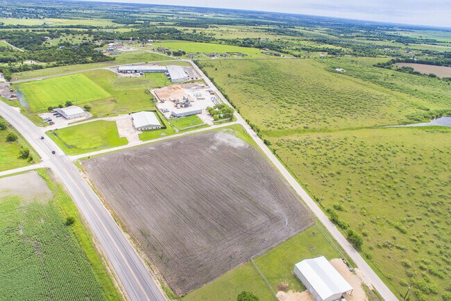
Property Detail
21 Grist Mill & Hwy
Austin-Round Rock-San Marcos, TX
A0398 A REUSS SURVEY, ACRES 6.122
R17633
HAYS
Vacantlandnec
Texas
B and X Area of moderate flood hazard, usually the area between the limits of the 100-year and 500-year floods.
6.12 AC
2024
Hays County
2025
Austin
010916
NEARBY LISTINGS FOR SALE OR LEASE
DEMOGRAPHICS near 21 Grist Mill & Hwy
1 mile
3 mile
5 mile
2025 Total Population
669
8,382
41,120
2030 Population
799
10,008
48,512
Pop Growth 2025-2030
+ 19.43%
+ 19.40%
+ 17.98%
Average Age
35
35
35
2025 Total Households
194
2,478
12,604
HH Growth 2025-2030
+ 19.59%
+ 20.38%
+ 19.09%
Median Household Inc
$85,243
$90,624
$92,771
Avg Household Size
3.50
3.40
3.20
2025 Avg HH Vehicles
2.00
2.00
2.00
Median Home Value
$278,571
$302,328
$325,284
Median Year Built
2010
2010
2010
Nearby Places
Map Layers
Map Styles
 Street
 Aerial
Layers
 Traffic
 Biking
Places
Listings with unknown addresses are not visible on the map
- Restaurants
- Banks
- Shops
- Fitness
- Groceries
PUBLIC TRANSPORTATION
AIRPORT
Austin-Bergstrom International
Drive
Walk
Distance
Austin-Bergstrom International
33 min
22.8 mi
Freight Ports
Calhoun Port
Drive
Walk
Distance
Calhoun Port
170 min
135.9 mi
SALE & LEASE HISTORY
LISTING DATE
SALE/LEASE

Sep 28, 2023
For Sale
Oct 03, 2022
For Lease
Oct 03, 2022
For Sale
Jun 02, 2021
For Sale
Nearby Properties
Address
Land Use
TOTAL SIZE
Lot Size
Zoning
Address
Land Use
TOTAL SIZE
Lot Size
Zoning
212,026 SF
13.82 AC
Address
Land Use
TOTAL SIZE
Lot Size
Zoning
2,663 SF
176.58 AC
Address
Land Use
TOTAL SIZE
Lot Size
Zoning
672 SF
1.55 AC
Address
Land Use
TOTAL SIZE
Lot Size
Zoning
96,000 SF
10 AC
Address
Land Use
TOTAL SIZE
Lot Size
Zoning
3,510 SF
136.76 AC
Address
Land Use
TOTAL SIZE
Lot Size
Zoning
47.48 AC
Address
Land Use
TOTAL SIZE
Lot Size
Zoning
41.87 AC
Address
Land Use
TOTAL SIZE
Lot Size
Zoning
71,895 SF
10.01 AC
Address
Land Use
TOTAL SIZE
Lot Size
Zoning
876 SF
105.47 AC
Address
Land Use
TOTAL SIZE
Lot Size
Zoning
42.54 AC
Address
Land Use
TOTAL SIZE
Lot Size
Zoning
Address
Land Use
TOTAL SIZE
Lot Size
Zoning
6,095 SF
15 AC
Address
Land Use
TOTAL SIZE
Lot Size
Zoning
34.37 AC
Address
Land Use
TOTAL SIZE
Lot Size
Zoning
76.97 AC
Address
Land Use
TOTAL SIZE
Lot Size
Zoning
106,335 SF
44.81 AC
Address
Land Use
TOTAL SIZE
Lot Size
Zoning
11,991 SF
6.47 AC
Address
Land Use
TOTAL SIZE
Lot Size
Zoning
52.85 AC
Address
Land Use
TOTAL SIZE
Lot Size
Zoning
98.70 AC
Address
Land Use
TOTAL SIZE
Lot Size
Zoning
4.47 AC
Address
Land Use
TOTAL SIZE
Lot Size
Zoning
37.97 AC
Address
Land Use
TOTAL SIZE
Lot Size
Zoning
6.50 AC
Address
Land Use
TOTAL SIZE
Lot Size
Zoning
6,000 SF
2.32 AC
Address
Land Use
TOTAL SIZE
Lot Size
Zoning
20,000 SF
50 AC
Address
Land Use
TOTAL SIZE
Lot Size
Zoning
7,182 SF
7.44 AC
Address
Land Use
TOTAL SIZE
Lot Size
Zoning
4,500 SF
2.30 AC
Address
Land Use
TOTAL SIZE
Lot Size
Zoning
32.38 AC
Address
Land Use
TOTAL SIZE
Lot Size
Zoning
62.50 AC
Address
Land Use
TOTAL SIZE
Lot Size
Zoning
12,284 SF
2 AC
Address
Land Use
TOTAL SIZE
Lot Size
Zoning
18.36 AC
The World's #1 Commercial Real Estate Marketplace
Connect with us
© 2026 CoStar Group
The information above has been obtained from sources believed reliable. While we do not doubt its accuracy we have not verified it and make no guarantee, warranty or representation about it. It is your responsibility to independently confirm its accuracy and completeness. Any projections, opinions, assumptions, or estimates used are for example only and do not represent the current or future performance of the property. The value of this transaction to you depends on tax and other factors which should be evaluated by your tax, financial, and legal advisors. You and your advisors should conduct a careful, independent investigation of the property to determine to your satisfaction the suitability of the property for your needs.