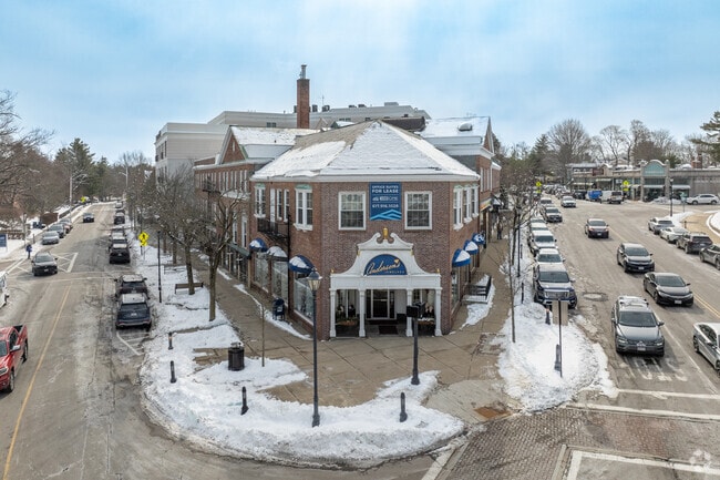
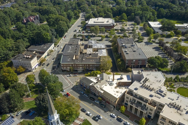
Property Record
570 Washington St, Wellesley, MA 02482
NEARBY LISTINGS FOR SALE OR LEASE
Property Detail
570 Washington St
WELL-000124-000015
Norfolk
Storebuilding
Massachusetts
X
0.31 AC
25021C0016F
Wellesley/Needham
2025
Boston
2025
Boston-Cambridge-Newton, MA-NH
404400
DEMOGRAPHICS near 570 Washington St
1 mile
3 mile
5 mile
2024 Total Population
10,767
57,685
145,947
2029 Population
10,789
57,602
145,127
Pop Growth 2024-2029
+ 0.20%
(0.14%)
(0.56%)
Average Age
39
41
41
2024 Total Households
3,271
19,398
52,034
HH Growth 2024-2029
+ 0.15%
(0.22%)
(0.64%)
Median Household Inc
$206,568
$210,112
$183,655
Avg Household Size
2.60
2.80
2.70
2024 Avg HH Vehicles
2.00
2.00
2.00
Median Home Value
$1,087,866
$1,044,149
$997,428
Median Year Built
1959
1959
1958
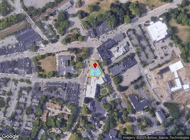
Nearby Places
Map Layers
Map Styles
 Street
 Aerial
Transit
 Traffic
 Biking
Places
Listings with unknown addresses are not visible on the map
- Restaurants
- Banks
- Shops
- Fitness
- Groceries
PUBLIC TRANSPORTATION
TRANSIT/SUBWAY
Wellesley Square (Framingham/Worcester Line - Massachusetts Bay Transportation Authority Commuter Rail (Purple Line))
Drive
Walk
Distance
Wellesley Square (Framingham/Worcester Line - Massachusetts Bay Transportation Authority Commuter Rail (Purple Line))
2 min
7 min
0.4 mi
COMMUTER RAIL
Wellesley Square (Framingham/Worcester Line - Massachusetts Bay Transportation Authority Commuter Rail (Purple Line))
Drive
Walk
Distance
Wellesley Square (Framingham/Worcester Line - Massachusetts Bay Transportation Authority Commuter Rail (Purple Line))
2 min
7 min
0.3 mi
Wellesley Hills (Framingham/Worcester Line - Massachusetts Bay Transportation Authority Commuter Rail (Purple Line))
Drive
Walk
Distance
Wellesley Hills (Framingham/Worcester Line - Massachusetts Bay Transportation Authority Commuter Rail (Purple Line))
2 min
1.4 mi
AIRPORT
General Edward Lawrence Logan International
Drive
Walk
Distance
General Edward Lawrence Logan International
28 min
17.8 mi
Worcester Regional
Drive
Walk
Distance
Worcester Regional
55 min
32.2 mi
Freight Ports
Port of Boston
Drive
Walk
Distance
Port of Boston
27 min
16.2 mi
SALE & LEASE HISTORY
LISTING DATE
SALE/LEASE

Sep 12, 2025
For Sale
Sep 12, 2019
For Lease
Oct 01, 2021
For Lease
Nov 02, 2020
For Lease
Dec 20, 2017
For Lease
Nearby Properties
Address
Land Use
TOTAL SIZE
Lot Size
Zoning
Address
Land Use
TOTAL SIZE
Lot Size
Zoning
522,600 SF
59.54 AC
A2
Address
Land Use
TOTAL SIZE
Lot Size
Zoning
10.87 AC
SRD 10
Address
Land Use
TOTAL SIZE
Lot Size
Zoning
15,974 SF
2.45 AC
ED
Address
Land Use
TOTAL SIZE
Lot Size
Zoning
6.33 AC
SR10
Address
Land Use
TOTAL SIZE
Lot Size
Zoning
15.08 AC
SR10
Address
Land Use
TOTAL SIZE
Lot Size
Zoning
1,683 SF
46.10 AC
SR15
Address
Land Use
TOTAL SIZE
Lot Size
Zoning
122,748 SF
16.90 AC
HPU
Address
Land Use
TOTAL SIZE
Lot Size
Zoning
49.88 AC
T
Address
Land Use
TOTAL SIZE
Lot Size
Zoning
3.80 AC
Address
Land Use
TOTAL SIZE
Lot Size
Zoning
25.70 AC
SR10
Address
Land Use
TOTAL SIZE
Lot Size
Zoning
80.85 AC
SR40
Address
Land Use
TOTAL SIZE
Lot Size
Zoning
13,244 SF
12.72 AC
SR10
Address
Land Use
TOTAL SIZE
Lot Size
Zoning
75,625 SF
23.23 AC
B
Address
Land Use
TOTAL SIZE
Lot Size
Zoning
7.15 AC
Address
Land Use
TOTAL SIZE
Lot Size
Zoning
1,592 SF
10.65 AC
ED
Address
Land Use
TOTAL SIZE
Lot Size
Zoning
139,710 SF
60.70 AC
SRA
Address
Land Use
TOTAL SIZE
Lot Size
Zoning
7.85 AC
SR10
Address
Land Use
TOTAL SIZE
Lot Size
Zoning
1.43 AC
Address
Land Use
TOTAL SIZE
Lot Size
Zoning
105 AC
SRD 30
Address
Land Use
TOTAL SIZE
Lot Size
Zoning
45.04 AC
ED
Address
Land Use
TOTAL SIZE
Lot Size
Zoning
455 SF
18.97 AC
SR10
Address
Land Use
TOTAL SIZE
Lot Size
Zoning
182.10 AC
O
Address
Land Use
TOTAL SIZE
Lot Size
Zoning
28.45 AC
Address
Land Use
TOTAL SIZE
Lot Size
Zoning
90,646 SF
10.63 AC
SRB
Address
Land Use
TOTAL SIZE
Lot Size
Zoning
2.19 AC
SRD 15
Address
Land Use
TOTAL SIZE
Lot Size
Zoning
14.06 AC
ED
Address
Land Use
TOTAL SIZE
Lot Size
Zoning
39 AC
ED
Address
Land Use
TOTAL SIZE
Lot Size
Zoning
8.50 AC
SR15
Address
Land Use
TOTAL SIZE
Lot Size
Zoning
41.94 AC
CON
Address
Land Use
TOTAL SIZE
Lot Size
Zoning
The World's #1 Commercial Real Estate Marketplace
Connect with us
© 2026 CoStar Group
The information above has been obtained from sources believed reliable. While we do not doubt its accuracy we have not verified it and make no guarantee, warranty or representation about it. It is your responsibility to independently confirm its accuracy and completeness. Any projections, opinions, assumptions, or estimates used are for example only and do not represent the current or future performance of the property. The value of this transaction to you depends on tax and other factors which should be evaluated by your tax, financial, and legal advisors. You and your advisors should conduct a careful, independent investigation of the property to determine to your satisfaction the suitability of the property for your needs.