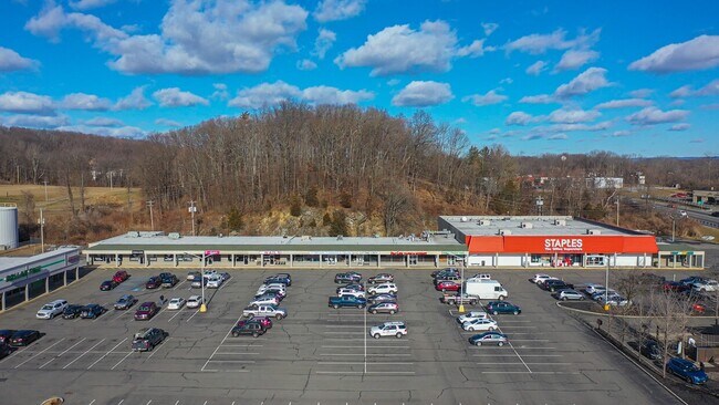
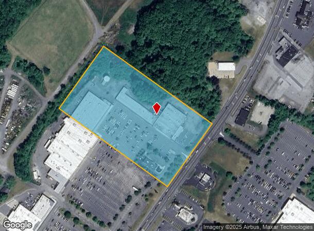
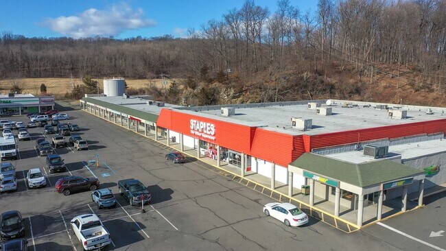
Property Record
21 Hampton House Rd, Newton, NJ 07860
NEARBY LISTINGS FOR SALE OR LEASE
Property Detail
21 Hampton House Rd
10-03501-0000-00030-04
Sussex
Regionalshoppingcenterormallwithanchorstore
New Jersey
X
30.4
34037C0303E
8.90 AC
2024
Sussex County
2025
Northern New Jersey
010400
Newark, NJ-PA
DEMOGRAPHICS near 21 Hampton House Rd
1 Mile
3 Mile
5 Mile
2024 Total Population
1,846
13,691
26,674
2029 Population
1,849
13,796
26,875
Pop Growth 2024-2029
+ 0.16%
+ 0.77%
+ 0.75%
Average Age
44
44
44
2024 Total Households
826
5,502
10,138
HH Growth 2024-2029
+ 0.36%
+ 0.87%
+ 0.80%
Median Household Inc
$68,092
$81,397
$102,305
Avg Household Size
2.20
2.40
2.50
2024 Avg HH Vehicles
2.00
2.00
2.00
Median Home Value
$237,165
$285,899
$338,675
Median Year Built
1974
1970
1972
Nearby Places
Map Layers
Map Styles
 Street
 Aerial
- Restaurants
- Banks
- Shops
- Fitness
- Groceries
Nearby Properties
Address
Land Use
TOTAL SIZE
Lot Size
Zoning
Address
Land Use
TOTAL SIZE
Lot Size
Zoning
20 AC
SD-1
Address
Land Use
TOTAL SIZE
Lot Size
Zoning
49.29 AC
SD-7
Address
Land Use
TOTAL SIZE
Lot Size
Zoning
6.10 AC
T-5+
Address
Land Use
TOTAL SIZE
Lot Size
Zoning
4.56 AC
T-4
Address
Land Use
TOTAL SIZE
Lot Size
Zoning
88.63 AC
SD-2
Address
Land Use
TOTAL SIZE
Lot Size
Zoning
96.14 AC
R-2
Address
Land Use
TOTAL SIZE
Lot Size
Zoning
20.50 AC
SD-6
Address
Land Use
TOTAL SIZE
Lot Size
Zoning
47,400 SF
71 AC
SD-4
Address
Land Use
TOTAL SIZE
Lot Size
Zoning
800 SF
13.50 AC
T-3
Address
Land Use
TOTAL SIZE
Lot Size
Zoning
11.96 AC
SD-3
Address
Land Use
TOTAL SIZE
Lot Size
Zoning
7.21 AC
T-5
Address
Land Use
TOTAL SIZE
Lot Size
Zoning
12,504 SF
3.14 AC
SD-3
Address
Land Use
TOTAL SIZE
Lot Size
Zoning
Address
Land Use
TOTAL SIZE
Lot Size
Zoning
17.79 AC
SD-3
Address
Land Use
TOTAL SIZE
Lot Size
Zoning
2.09 AC
T-5
Address
Land Use
TOTAL SIZE
Lot Size
Zoning
20.62 AC
HCMF
Address
Land Use
TOTAL SIZE
Lot Size
Zoning
52.16 AC
HCMF
Address
Land Use
TOTAL SIZE
Lot Size
Zoning
72,992 SF
4.75 AC
SD-3
Address
Land Use
TOTAL SIZE
Lot Size
Zoning
5.20 AC
T-3
Address
Land Use
TOTAL SIZE
Lot Size
Zoning
50,814 SF
8.62 AC
SD-3
Address
Land Use
TOTAL SIZE
Lot Size
Zoning
26,611 SF
1.21 AC
T-5+
Address
Land Use
TOTAL SIZE
Lot Size
Zoning
45,532 SF
10.31 AC
R1
Address
Land Use
TOTAL SIZE
Lot Size
Zoning
68,221 SF
7.89 AC
SD-1
Address
Land Use
TOTAL SIZE
Lot Size
Zoning
1,140 SF
1.45 AC
SD-6
Address
Land Use
TOTAL SIZE
Lot Size
Zoning
11 AC
SD-6
Address
Land Use
TOTAL SIZE
Lot Size
Zoning
0.56 AC
T-5
Address
Land Use
TOTAL SIZE
Lot Size
Zoning
2,982 SF
5.41 AC
SD-3
Address
Land Use
TOTAL SIZE
Lot Size
Zoning
2.24 AC
T-5
Address
Land Use
TOTAL SIZE
Lot Size
Zoning
2.49 AC
SD-3
The World's #1 Commercial Real Estate Marketplace
Connect with us
© 2026 CoStar Group
The information above has been obtained from sources believed reliable. While we do not doubt its accuracy we have not verified it and make no guarantee, warranty or representation about it. It is your responsibility to independently confirm its accuracy and completeness. Any projections, opinions, assumptions, or estimates used are for example only and do not represent the current or future performance of the property. The value of this transaction to you depends on tax and other factors which should be evaluated by your tax, financial, and legal advisors. You and your advisors should conduct a careful, independent investigation of the property to determine to your satisfaction the suitability of the property for your needs.