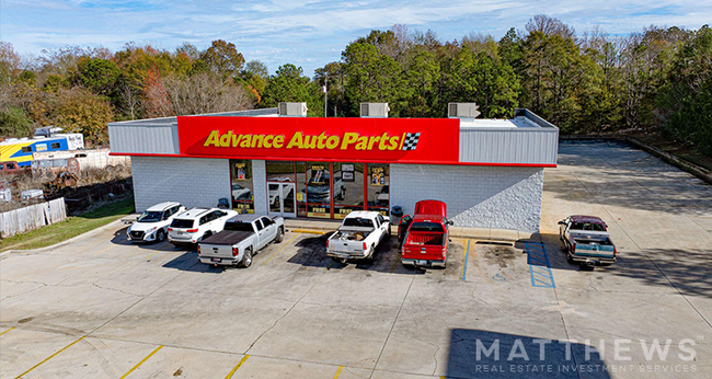
Property Record
21 Highway 21 S, Monroeville, AL 36460

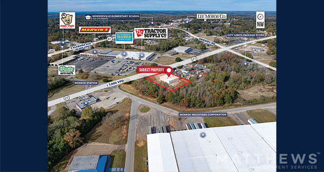
NEARBY LISTINGS FOR SALE OR LEASE
Property Detail
21 Highway 21 S
Storebuilding
0.83AC BEG @ E RW HWY 21 BYPASS 965(S) SLY OF N LN OF SE14 ELY 240 SLY 150 WLY 240 NLY 150 ALG RW TO POB.
X
Monroe
01099C0365C
Alabama
2025
0.85 AC
2024
Alabama South Area
076102
Other Market Areas
6,889 SF
26010140000370010
DEMOGRAPHICS near 21 Highway 21 S
1 Mile
3 Mile
5 Mile
2024 Total Population
2,632
6,080
8,691
2029 Population
2,576
5,904
8,450
Pop Growth 2024-2029
(2.13%)
(2.89%)
(2.77%)
Average Age
41
41
42
2024 Total Households
1,142
2,580
3,678
HH Growth 2024-2029
(1.84%)
(2.60%)
(2.45%)
Median Household Inc
$33,504
$31,506
$32,203
Avg Household Size
2.20
2.30
2.30
2024 Avg HH Vehicles
2.00
2.00
2.00
Median Home Value
$131,122
$125,311
$126,240
Median Year Built
1979
1980
1980
Nearby Places
Map Layers
Map Styles
 Street
 Aerial
- Restaurants
- Banks
- Shops
- Fitness
- Groceries
SALE & LEASE HISTORY
LISTING DATE
SALE/LEASE

Jul 31, 2025
For Sale
Jan 10, 2025
For Sale
Nearby Properties
Address
Land Use
TOTAL SIZE
Lot Size
Zoning
Address
Land Use
TOTAL SIZE
Lot Size
Zoning
52,740 SF
17 AC
Address
Land Use
TOTAL SIZE
Lot Size
Zoning
318,178 SF
3 AC
Address
Land Use
TOTAL SIZE
Lot Size
Zoning
225,156 SF
18 AC
Address
Land Use
TOTAL SIZE
Lot Size
Zoning
91,498 SF
34 AC
Address
Land Use
TOTAL SIZE
Lot Size
Zoning
24,022 SF
2.62 AC
Address
Land Use
TOTAL SIZE
Lot Size
Zoning
55,362 SF
0.78 AC
Address
Land Use
TOTAL SIZE
Lot Size
Zoning
11,123 SF
6 AC
Address
Land Use
TOTAL SIZE
Lot Size
Zoning
14,131 SF
10 AC
Address
Land Use
TOTAL SIZE
Lot Size
Zoning
4,645 SF
79 AC
Address
Land Use
TOTAL SIZE
Lot Size
Zoning
5,076 SF
9 AC
Address
Land Use
TOTAL SIZE
Lot Size
Zoning
38,564 SF
7 AC
Address
Land Use
TOTAL SIZE
Lot Size
Zoning
1,965 SF
9.90 AC
Address
Land Use
TOTAL SIZE
Lot Size
Zoning
19,840 SF
1.16 AC
Address
Land Use
TOTAL SIZE
Lot Size
Zoning
53,365 SF
8 AC
Address
Land Use
TOTAL SIZE
Lot Size
Zoning
51,779 SF
6 AC
Address
Land Use
TOTAL SIZE
Lot Size
Zoning
23,689 SF
7 AC
Address
Land Use
TOTAL SIZE
Lot Size
Zoning
9,220 SF
18 AC
Address
Land Use
TOTAL SIZE
Lot Size
Zoning
8,053 SF
3 AC
Address
Land Use
TOTAL SIZE
Lot Size
Zoning
6,692 SF
7 AC
Address
Land Use
TOTAL SIZE
Lot Size
Zoning
3,952 SF
3 AC
Address
Land Use
TOTAL SIZE
Lot Size
Zoning
13,614 SF
2 AC
Address
Land Use
TOTAL SIZE
Lot Size
Zoning
17,647 SF
5 AC
Address
Land Use
TOTAL SIZE
Lot Size
Zoning
25,450 SF
2.52 AC
Address
Land Use
TOTAL SIZE
Lot Size
Zoning
39,750 SF
6 AC
Address
Land Use
TOTAL SIZE
Lot Size
Zoning
24,778 SF
1.27 AC
Address
Land Use
TOTAL SIZE
Lot Size
Zoning
20,455 SF
6 AC
The World's #1 Commercial Real Estate Marketplace
Connect with us
© 2025 CoStar Group
The information above has been obtained from sources believed reliable. While we do not doubt its accuracy we have not verified it and make no guarantee, warranty or representation about it. It is your responsibility to independently confirm its accuracy and completeness. Any projections, opinions, assumptions, or estimates used are for example only and do not represent the current or future performance of the property. The value of this transaction to you depends on tax and other factors which should be evaluated by your tax, financial, and legal advisors. You and your advisors should conduct a careful, independent investigation of the property to determine to your satisfaction the suitability of the property for your needs.